Property Record
219 Fox Sauk Rd, Ottumwa, IA 52501


NEARBY LISTINGS FOR SALE OR LEASE
-
-
View all Ottumwa listings for sale on LoopNet.com
Property Detail
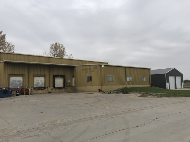
219 Fox Sauk Rd
Ottumwa, IA
O.A.D.C. INDUSTRIAL PARK SE PT L12 CM SW COR 6-72-13/N W LN ETC
007411220008000
Wapello
Warehouse
Iowa
2025
5.03 AC
2025
Iowa Southeast Area
960300
Other Market Areas
11,595 SF
DEMOGRAPHICS near 219 Fox Sauk Rd
1 Mile
3 Mile
5 Mile
2024 Total Population
1,707
10,271
24,602
2029 Population
1,669
10,132
24,170
Pop Growth 2024-2029
(2.23%)
(1.35%)
(1.76%)
Average Age
40
39
39
2024 Total Households
636
3,969
9,701
HH Growth 2024-2029
(2.36%)
(1.44%)
(1.83%)
Median Household Inc
$74,303
$64,576
$51,363
Avg Household Size
2.40
2.40
2.40
2024 Avg HH Vehicles
2.00
2.00
2.00
Median Home Value
$160,987
$134,907
$91,978
Median Year Built
1969
1958
1953
Nearby Places
Map Layers
Map Styles
 Street
 Aerial
- Restaurants
- Banks
- Shops
- Fitness
- Groceries
PUBLIC TRANSPORTATION
COMMUTER RAIL
Ottumwa Amtrak Station (California Zephyr - Amtrak)
DRIVE
WALK
Distance
Ottumwa Amtrak Station (California Zephyr - Amtrak)
6 min
3.8 mi
Freight Ports
Port Milwaukee
DRIVE
WALK
Distance
Port Milwaukee
407 min
348.4 mi
SALE & LEASE HISTORY
LISTING DATE
SALE/LEASE

Oct 30, 2019
For Sale
Nearby Properties
Address
Land Use
TOTAL SIZE
Lot Size
Zoning
Address
Land Use
TOTAL SIZE
Lot Size
Zoning
1,680 SF
17.26 AC
Address
Land Use
TOTAL SIZE
Lot Size
Zoning
34,134 SF
9.89 AC
Address
Land Use
TOTAL SIZE
Lot Size
Zoning
87,967 SF
4.28 AC
Address
Land Use
TOTAL SIZE
Lot Size
Zoning
217,810 SF
7.80 AC
Address
Land Use
TOTAL SIZE
Lot Size
Zoning
12,620 SF
4.87 AC
Address
Land Use
TOTAL SIZE
Lot Size
Zoning
7,995 SF
0.14 AC
Address
Land Use
TOTAL SIZE
Lot Size
Zoning
49,084 SF
3.87 AC
Address
Land Use
TOTAL SIZE
Lot Size
Zoning
23,742 SF
16.62 AC
Address
Land Use
TOTAL SIZE
Lot Size
Zoning
40,939 SF
5.72 AC
Address
Land Use
TOTAL SIZE
Lot Size
Zoning
29,226 SF
0.14 AC
Address
Land Use
TOTAL SIZE
Lot Size
Zoning
7,044 SF
2.39 AC
Address
Land Use
TOTAL SIZE
Lot Size
Zoning
178,592 SF
5.35 AC
Address
Land Use
TOTAL SIZE
Lot Size
Zoning
4.62 AC
Address
Land Use
TOTAL SIZE
Lot Size
Zoning
22,672 SF
2.16 AC
Address
Land Use
TOTAL SIZE
Lot Size
Zoning
10,021 SF
2.01 AC
Address
Land Use
TOTAL SIZE
Lot Size
Zoning
27,684 SF
9.26 AC
Address
Land Use
TOTAL SIZE
Lot Size
Zoning
30,000 SF
1.08 AC
Address
Land Use
TOTAL SIZE
Lot Size
Zoning
21,582 SF
3.69 AC
Address
Land Use
TOTAL SIZE
Lot Size
Zoning
24,572 SF
3.91 AC
Address
Land Use
TOTAL SIZE
Lot Size
Zoning
5,244 SF
0.22 AC
Address
Land Use
TOTAL SIZE
Lot Size
Zoning
10,640 SF
1.48 AC
Address
Land Use
TOTAL SIZE
Lot Size
Zoning
24,432 SF
1.50 AC
Address
Land Use
TOTAL SIZE
Lot Size
Zoning
18,186 SF
1.62 AC
Address
Land Use
TOTAL SIZE
Lot Size
Zoning
10,272 SF
4.35 AC
Address
Land Use
TOTAL SIZE
Lot Size
Zoning
8,713 SF
1.67 AC
Address
Land Use
TOTAL SIZE
Lot Size
Zoning
29,607 SF
13 AC
Address
Land Use
TOTAL SIZE
Lot Size
Zoning
59,256 SF
6.17 AC
Address
Land Use
TOTAL SIZE
Lot Size
Zoning
5.52 AC
Address
Land Use
TOTAL SIZE
Lot Size
Zoning
11,415 SF
2.32 AC
Address
Land Use
TOTAL SIZE
Lot Size
Zoning
9,524 SF
1.23 AC
The World's #1 Commercial Real Estate Marketplace
Connect with us
© 2026 CoStar Group
The information above has been obtained from sources believed reliable. While we do not doubt its accuracy we have not verified it and make no guarantee, warranty or representation about it. It is your responsibility to independently confirm its accuracy and completeness. Any projections, opinions, assumptions, or estimates used are for example only and do not represent the current or future performance of the property. The value of this transaction to you depends on tax and other factors which should be evaluated by your tax, financial, and legal advisors. You and your advisors should conduct a careful, independent investigation of the property to determine to your satisfaction the suitability of the property for your needs.