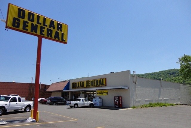
Property Record
219 Gault Ave S, Fort Payne, AL 35967


NEARBY LISTINGS FOR SALE OR LEASE
Property Detail
219 Gault Ave S
23-03-07-4-004-001.001
City Add
Storebuilding
S7 T7 R9 FORT PAYNE CONT 1.1 ACCITY ADDPT OF BLK 79 DESC AS: BEG SW COR OFBLK TH: NE 257' SE 315.6' SW 113.95' NW244' SW
X
De Kalb
01049C0303E
Alabama
2025
1.10 AC
2025
Alabama North Area
961000
Other Market Areas
17,280 SF
Fort Payne, AL
DEMOGRAPHICS near 219 Gault Ave S
1 Mile
3 Mile
5 Mile
2024 Total Population
3,261
9,444
16,012
2029 Population
3,310
9,586
16,261
Pop Growth 2024-2029
+ 1.50%
+ 1.50%
+ 1.56%
Average Age
37
38
38
2024 Total Households
1,225
3,502
5,940
HH Growth 2024-2029
+ 1.39%
+ 1.40%
+ 1.45%
Median Household Inc
$35,754
$36,189
$39,006
Avg Household Size
2.50
2.60
2.60
2024 Avg HH Vehicles
2.00
2.00
2.00
Median Home Value
$90,759
$96,822
$114,427
Median Year Built
1958
1975
1979
Nearby Places
Map Layers
Map Styles
 Street
 Aerial
- Restaurants
- Banks
- Shops
- Fitness
- Groceries
Nearby Properties
Address
Land Use
TOTAL SIZE
Lot Size
Zoning
Address
Land Use
TOTAL SIZE
Lot Size
Zoning
61,425 SF
7 AC
Address
Land Use
TOTAL SIZE
Lot Size
Zoning
13,477 SF
2 AC
Address
Land Use
TOTAL SIZE
Lot Size
Zoning
4,210 SF
10 AC
Address
Land Use
TOTAL SIZE
Lot Size
Zoning
75,020 SF
39.56 AC
Address
Land Use
TOTAL SIZE
Lot Size
Zoning
10,541 SF
Address
Land Use
TOTAL SIZE
Lot Size
Zoning
12,278 SF
2.30 AC
Address
Land Use
TOTAL SIZE
Lot Size
Zoning
10,975 SF
2.10 AC
Address
Land Use
TOTAL SIZE
Lot Size
Zoning
13,492 SF
2.70 AC
Address
Land Use
TOTAL SIZE
Lot Size
Zoning
18,108 SF
12.20 AC
Address
Land Use
TOTAL SIZE
Lot Size
Zoning
10,290 SF
2 AC
Address
Land Use
TOTAL SIZE
Lot Size
Zoning
The World's #1 Commercial Real Estate Marketplace
Connect with us
© 2026 CoStar Group
The information above has been obtained from sources believed reliable. While we do not doubt its accuracy we have not verified it and make no guarantee, warranty or representation about it. It is your responsibility to independently confirm its accuracy and completeness. Any projections, opinions, assumptions, or estimates used are for example only and do not represent the current or future performance of the property. The value of this transaction to you depends on tax and other factors which should be evaluated by your tax, financial, and legal advisors. You and your advisors should conduct a careful, independent investigation of the property to determine to your satisfaction the suitability of the property for your needs.