Property Record
219 Louisa St, Warrior, AL 35180
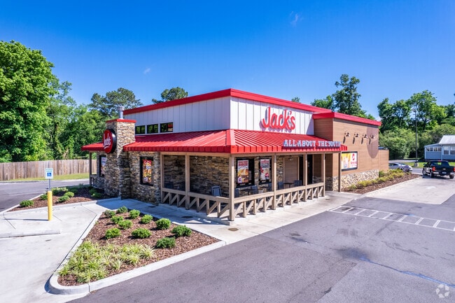

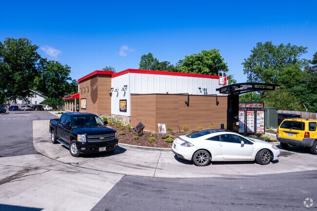
Property Detail
219 Louisa St
03-00-24-2-004-002.000
LOT A JACKS FAMILY RESTAURANTS LP ADDITION TO WARRIOR PB 252 PG 63
Restaurantbuilding
Jefferson
B
Alabama
B and X Area of moderate flood hazard, usually the area between the limits of the 100-year and 500-year floods.
a
2024
3.31 AC
2025
Fultondale
011401
Birmingham
3,212 SF
Birmingham, AL
NEARBY LISTINGS FOR SALE OR LEASE
-
-
View all Warrior listings for sale on LoopNet.com
DEMOGRAPHICS near 219 Louisa St
1 mile
3 mile
5 mile
2025 Total Population
1,504
6,452
18,064
2030 Population
1,500
6,469
18,149
Pop Growth 2025-2030
(0.27%)
+ 0.26%
+ 0.47%
Average Age
42
40
40
2025 Total Households
655
2,533
6,816
HH Growth 2025-2030
(0.31%)
+ 0.32%
+ 0.50%
Median Household Inc
$57,105
$69,148
$79,642
Avg Household Size
2.30
2.60
2.60
2025 Avg HH Vehicles
2.00
2.00
2.00
Median Home Value
$132,371
$226,149
$253,822
Median Year Built
1970
1989
1993
Nearby Places
Map Layers
Map Styles
 Street
 Aerial
Layers
 Traffic
 Biking
Places
Listings with unknown addresses are not visible on the map
- Restaurants
- Banks
- Shops
- Fitness
- Groceries
PUBLIC TRANSPORTATION
AIRPORT
Birmingham-Shuttlesworth International
Drive
Walk
Distance
Birmingham-Shuttlesworth International
35 min
28.0 mi
Freight Ports
Port of Mobile
Drive
Walk
Distance
Port of Mobile
304 min
277.8 mi
Nearby Properties
Address
Land Use
TOTAL SIZE
Lot Size
Zoning
Address
Land Use
TOTAL SIZE
Lot Size
Zoning
27,903 SF
13 AC
Address
Land Use
TOTAL SIZE
Lot Size
Zoning
55,467 SF
7 AC
GB
Address
Land Use
TOTAL SIZE
Lot Size
Zoning
13,988 SF
2 AC
B
Address
Land Use
TOTAL SIZE
Lot Size
Zoning
6,296 SF
2.10 AC
Address
Land Use
TOTAL SIZE
Lot Size
Zoning
6,460 SF
5.20 AC
Address
Land Use
TOTAL SIZE
Lot Size
Zoning
6,370 SF
4.14 AC
B3
Address
Land Use
TOTAL SIZE
Lot Size
Zoning
3,000 SF
3 AC
Address
Land Use
TOTAL SIZE
Lot Size
Zoning
6,863 SF
1 AC
C1-A
Address
Land Use
TOTAL SIZE
Lot Size
Zoning
7,105 SF
1.70 AC
Address
Land Use
TOTAL SIZE
Lot Size
Zoning
34,552 SF
3 AC
I1
Address
Land Use
TOTAL SIZE
Lot Size
Zoning
5,100 SF
1 AC
B
Address
Land Use
TOTAL SIZE
Lot Size
Zoning
6,509 SF
4 AC
B
Address
Land Use
TOTAL SIZE
Lot Size
Zoning
10,000 SF
1 AC
C1
Address
Land Use
TOTAL SIZE
Lot Size
Zoning
6,061 SF
3.35 AC
Address
Land Use
TOTAL SIZE
Lot Size
Zoning
41,296 SF
2 AC
B
Address
Land Use
TOTAL SIZE
Lot Size
Zoning
23,306 SF
2 AC
B2
Address
Land Use
TOTAL SIZE
Lot Size
Zoning
1,401 SF
1 AC
C1 A
Address
Land Use
TOTAL SIZE
Lot Size
Zoning
10,125 SF
2 AC
GB
Address
Land Use
TOTAL SIZE
Lot Size
Zoning
10,672 SF
1.27 AC
C1
Address
Land Use
TOTAL SIZE
Lot Size
Zoning
10,000 SF
8.20 AC
Address
Land Use
TOTAL SIZE
Lot Size
Zoning
3,437 SF
1 AC
R1&B
Address
Land Use
TOTAL SIZE
Lot Size
Zoning
7,225 SF
0.93 AC
B1
Address
Land Use
TOTAL SIZE
Lot Size
Zoning
9,106 SF
1 AC
B1
Address
Land Use
TOTAL SIZE
Lot Size
Zoning
2,400 SF
1.03 AC
Address
Land Use
TOTAL SIZE
Lot Size
Zoning
8,200 SF
1.50 AC
Address
Land Use
TOTAL SIZE
Lot Size
Zoning
5,822 SF
0.71 AC
R3
Address
Land Use
TOTAL SIZE
Lot Size
Zoning
4.30 AC
B
Address
Land Use
TOTAL SIZE
Lot Size
Zoning
10,400 SF
8.60 AC
Address
Land Use
TOTAL SIZE
Lot Size
Zoning
11,111 SF
1 AC
R2
Address
Land Use
TOTAL SIZE
Lot Size
Zoning
2,397 SF
1.46 AC
C1-A
The World's #1 Commercial Real Estate Marketplace
Connect with us
© 2026 CoStar Group
The information above has been obtained from sources believed reliable. While we do not doubt its accuracy we have not verified it and make no guarantee, warranty or representation about it. It is your responsibility to independently confirm its accuracy and completeness. Any projections, opinions, assumptions, or estimates used are for example only and do not represent the current or future performance of the property. The value of this transaction to you depends on tax and other factors which should be evaluated by your tax, financial, and legal advisors. You and your advisors should conduct a careful, independent investigation of the property to determine to your satisfaction the suitability of the property for your needs.