Property Record
219 Myrtle Ave, Carolina Beach, NC 28428

Property Detail
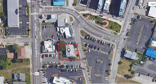
219 Myrtle Ave
R09006-003-009-000
D 8/9/10 CAR BCH
Restaurantbuilding
New Hanover
CBD,CENTRA
North Carolina
AE The base floodplain where base flood elevations are provided. AE Zones are now used on new format FIRMs instead of A1-A30 Zones.
9
2025
0.18 AC
2025
Carolina Beach
012201
Wilmington
2,440 SF
Wilmington, NC
NEARBY LISTINGS FOR SALE OR LEASE
-
-
View all Carolina Beach listings for sale on LoopNet.com
DEMOGRAPHICS near 219 Myrtle Ave
1 mile
3 mile
5 mile
2025 Total Population
6,701
18,175
27,188
2030 Population
7,520
20,322
29,817
Pop Growth 2025-2030
+ 12.22%
+ 11.81%
+ 9.67%
Average Age
47
49
47
2025 Total Households
3,048
8,434
12,043
HH Growth 2025-2030
+ 12.37%
+ 12.17%
+ 10.21%
Median Household Inc
$82,004
$91,606
$93,088
Avg Household Size
2.20
2.10
2.20
2025 Avg HH Vehicles
2.00
2.00
2.00
Median Home Value
$543,253
$535,193
$498,168
Median Year Built
1991
1996
1997
Nearby Places
Map Layers
Map Styles
 Street
 Aerial
Transit
 Traffic
 Biking
Places
Listings with unknown addresses are not visible on the map
- Restaurants
- Banks
- Shops
- Fitness
- Groceries
PUBLIC TRANSPORTATION
AIRPORT
Wilmington International
Drive
Walk
Distance
Wilmington International
40 min
21.8 mi
Freight Ports
Port of Wilmington
Drive
Walk
Distance
Port of Wilmington
24 min
13.4 mi
SALE & LEASE HISTORY
LISTING DATE
SALE/LEASE

Oct 23, 2020
For Sale
Nearby Properties
Address
Land Use
TOTAL SIZE
Lot Size
Zoning
Address
Land Use
TOTAL SIZE
Lot Size
Zoning
82,199 SF
12.06 AC
HB
Address
Land Use
TOTAL SIZE
Lot Size
Zoning
4,500 SF
1,948.40 AC
C
Address
Land Use
TOTAL SIZE
Lot Size
Zoning
103,040 SF
2.29 AC
CBD,CENTRA
Address
Land Use
TOTAL SIZE
Lot Size
Zoning
13,828 SF
18.07 AC
R-15,RESID
Address
Land Use
TOTAL SIZE
Lot Size
Zoning
MB-1,MARIN
Address
Land Use
TOTAL SIZE
Lot Size
Zoning
125 AC
C
Address
Land Use
TOTAL SIZE
Lot Size
Zoning
66,825 SF
1 AC
CBD,CENTRA
Address
Land Use
TOTAL SIZE
Lot Size
Zoning
1,665 SF
295.96 AC
C
Address
Land Use
TOTAL SIZE
Lot Size
Zoning
23,156 SF
1.84 AC
MF
Address
Land Use
TOTAL SIZE
Lot Size
Zoning
54,431 SF
10.71 AC
HB
Address
Land Use
TOTAL SIZE
Lot Size
Zoning
65,228 SF
7.53 AC
HB
Address
Land Use
TOTAL SIZE
Lot Size
Zoning
18.99 AC
R-1,WB RES
Address
Land Use
TOTAL SIZE
Lot Size
Zoning
59.50 AC
I-1,INDUST
Address
Land Use
TOTAL SIZE
Lot Size
Zoning
0.60 AC
R-1B
Address
Land Use
TOTAL SIZE
Lot Size
Zoning
26,172 SF
6.95 AC
HB
Address
Land Use
TOTAL SIZE
Lot Size
Zoning
MB-1,MARIN
Address
Land Use
TOTAL SIZE
Lot Size
Zoning
32,845 SF
3.02 AC
R-3,RESIDE
Address
Land Use
TOTAL SIZE
Lot Size
Zoning
36.76 AC
C
Address
Land Use
TOTAL SIZE
Lot Size
Zoning
0.02 AC
MB-1,MARIN
Address
Land Use
TOTAL SIZE
Lot Size
Zoning
32.58 AC
C
Address
Land Use
TOTAL SIZE
Lot Size
Zoning
2,880 SF
210.78 AC
R-15,RESID
Address
Land Use
TOTAL SIZE
Lot Size
Zoning
7,200 SF
7.01 AC
B-1,BUSINE
Address
Land Use
TOTAL SIZE
Lot Size
Zoning
26.08 AC
C
Address
Land Use
TOTAL SIZE
Lot Size
Zoning
25.32 AC
RA-2A
Address
Land Use
TOTAL SIZE
Lot Size
Zoning
1.47 AC
R-2,WB TWO
Address
Land Use
TOTAL SIZE
Lot Size
Zoning
24,984 SF
2.52 AC
HB
Address
Land Use
TOTAL SIZE
Lot Size
Zoning
1,890 SF
1.26 AC
MF
Address
Land Use
TOTAL SIZE
Lot Size
Zoning
1,493 SF
2.52 AC
R-3,RESIDE
Address
Land Use
TOTAL SIZE
Lot Size
Zoning
600 SF
12.46 AC
R-3,RESIDE
Address
Land Use
TOTAL SIZE
Lot Size
Zoning
23,378 SF
2.74 AC
HB
The World's #1 Commercial Real Estate Marketplace
Connect with us
© 2026 CoStar Group
The information above has been obtained from sources believed reliable. While we do not doubt its accuracy we have not verified it and make no guarantee, warranty or representation about it. It is your responsibility to independently confirm its accuracy and completeness. Any projections, opinions, assumptions, or estimates used are for example only and do not represent the current or future performance of the property. The value of this transaction to you depends on tax and other factors which should be evaluated by your tax, financial, and legal advisors. You and your advisors should conduct a careful, independent investigation of the property to determine to your satisfaction the suitability of the property for your needs.