Property Record
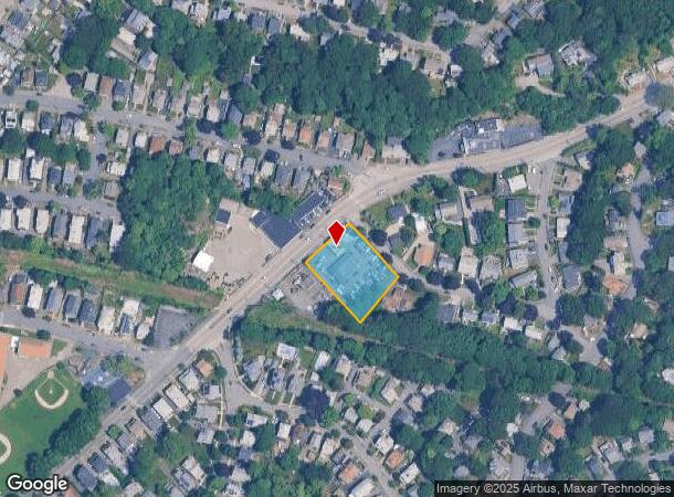
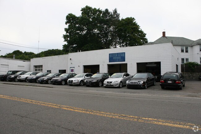
219 Paradise Rd, Swampscott, MA 01907

NEARBY LISTINGS FOR SALE OR LEASE
Property Detail
219 Paradise Rd
Servicestation
Essex
X
Massachusetts
25009C0531H
0.69 AC
2025
Saugus/Lynn
2025
Boston
202101
Boston-Cambridge-Newton, MA-NH
2,040 SF
SWAM-000015-000002
DEMOGRAPHICS near 219 Paradise Rd
1 Mile
3 Mile
5 Mile
2024 Total Population
21,133
128,979
231,536
2029 Population
20,971
127,383
228,869
Pop Growth 2024-2029
(0.77%)
(1.24%)
(1.15%)
Average Age
42
39
40
2024 Total Households
8,342
47,291
89,255
HH Growth 2024-2029
(0.79%)
(1.24%)
(1.24%)
Median Household Inc
$89,378
$72,826
$77,756
Avg Household Size
2.40
2.60
2.50
2024 Avg HH Vehicles
2.00
2.00
2.00
Median Home Value
$551,035
$496,369
$499,397
Median Year Built
1949
1949
1949
Nearby Places
Map Layers
Map Styles
 Street
 Aerial
- Restaurants
- Banks
- Shops
- Fitness
- Groceries
PUBLIC TRANSPORTATION
COMMUTER RAIL
Swampscott (Newburyport/Rockport Line - Massachusetts Bay Transportation Authority Commuter Rail (Purple Line))
DRIVE
WALK
Distance
Swampscott (Newburyport/Rockport Line - Massachusetts Bay Transportation Authority Commuter Rail (Purple Line))
2 min
19 min
0.8 mi
DRIVE
WALK
Distance
5 min
2.1 mi
AIRPORT
General Edward Lawrence Logan International
DRIVE
WALK
Distance
General Edward Lawrence Logan International
19 min
11.2 mi
Freight Ports
Port of Boston
DRIVE
WALK
Distance
Port of Boston
25 min
13.9 mi
Nearby Properties
Address
Land Use
TOTAL SIZE
Lot Size
Zoning
Address
Land Use
TOTAL SIZE
Lot Size
Zoning
9.73 AC
R5
Address
Land Use
TOTAL SIZE
Lot Size
Zoning
9,860 SF
17.80 AC
R1
Address
Land Use
TOTAL SIZE
Lot Size
Zoning
11,840 SF
0.67 AC
CBD
Address
Land Use
TOTAL SIZE
Lot Size
Zoning
4.51 AC
R5
Address
Land Use
TOTAL SIZE
Lot Size
Zoning
154,524 SF
5.90 AC
B3
Address
Land Use
TOTAL SIZE
Lot Size
Zoning
190,000 SF
24.42 AC
N/A
Address
Land Use
TOTAL SIZE
Lot Size
Zoning
303,568 SF
1.11 AC
LI
Address
Land Use
TOTAL SIZE
Lot Size
Zoning
153,855 SF
6.08 AC
A-2
Address
Land Use
TOTAL SIZE
Lot Size
Zoning
8.74 AC
WF1A
Address
Land Use
TOTAL SIZE
Lot Size
Zoning
151.89 AC
PC
Address
Land Use
TOTAL SIZE
Lot Size
Zoning
38,440 SF
8.95 AC
I
Address
Land Use
TOTAL SIZE
Lot Size
Zoning
123,903 SF
0.88 AC
CBD
Address
Land Use
TOTAL SIZE
Lot Size
Zoning
3.22 AC
R5
Address
Land Use
TOTAL SIZE
Lot Size
Zoning
15,240 SF
11.49 AC
WF3
Address
Land Use
TOTAL SIZE
Lot Size
Zoning
5.40 AC
R5
Address
Land Use
TOTAL SIZE
Lot Size
Zoning
223,689 SF
11.60 AC
R1
Address
Land Use
TOTAL SIZE
Lot Size
Zoning
205,353 SF
18.74 AC
Address
Land Use
TOTAL SIZE
Lot Size
Zoning
98,516 SF
5.01 AC
R1
Address
Land Use
TOTAL SIZE
Lot Size
Zoning
25.02 AC
WF1A
Address
Land Use
TOTAL SIZE
Lot Size
Zoning
68,296 SF
6.01 AC
R2
Address
Land Use
TOTAL SIZE
Lot Size
Zoning
9.58 AC
R3
Address
Land Use
TOTAL SIZE
Lot Size
Zoning
84,681 SF
3.53 AC
R5
Address
Land Use
TOTAL SIZE
Lot Size
Zoning
125,862 SF
5.30 AC
R1
Address
Land Use
TOTAL SIZE
Lot Size
Zoning
77,392 SF
6.82 AC
B3
Address
Land Use
TOTAL SIZE
Lot Size
Zoning
5 AC
B2
Address
Land Use
TOTAL SIZE
Lot Size
Zoning
80,069 SF
3.13 AC
A-2
Address
Land Use
TOTAL SIZE
Lot Size
Zoning
229,416 SF
14.81 AC
N/A
Address
Land Use
TOTAL SIZE
Lot Size
Zoning
76,589 SF
4.57 AC
R4
Address
Land Use
TOTAL SIZE
Lot Size
Zoning
7.28 AC
R3
Address
Land Use
TOTAL SIZE
Lot Size
Zoning
2.88 AC
R5
The World's #1 Commercial Real Estate Marketplace
Connect with us
© 2025 CoStar Group
The information above has been obtained from sources believed reliable. While we do not doubt its accuracy we have not verified it and make no guarantee, warranty or representation about it. It is your responsibility to independently confirm its accuracy and completeness. Any projections, opinions, assumptions, or estimates used are for example only and do not represent the current or future performance of the property. The value of this transaction to you depends on tax and other factors which should be evaluated by your tax, financial, and legal advisors. You and your advisors should conduct a careful, independent investigation of the property to determine to your satisfaction the suitability of the property for your needs.