Property Record
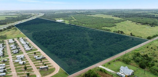
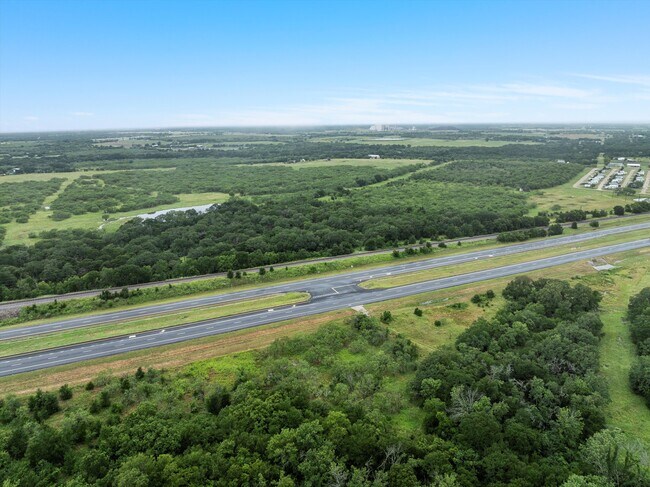
219 Rice Rd, Riesel, TX 76682

This Property Is For Sale
NEARBY LISTINGS FOR SALE OR LEASE
-
-
View all Riesel listings for sale on LoopNet.com
Property Detail
219 Rice Rd
42-120600-000701-6
Fantharp F
Commercialacreage
FANTHARP F ACRES 20.021, (38.528 AC S&E 18.507 AC IN FALLS CO LEAVING 20.021 AC)
X
Mclennan
48309C0600D
Texas
2024
20.02 AC
2025
Waco
003602
Other Market Areas
1,292 SF
Waco, TX
DEMOGRAPHICS near 219 Rice Rd
1 mile
3 mile
5 mile
2024 Total Population
171
1,669
2,632
2029 Population
179
1,745
2,747
Pop Growth 2024-2029
+ 4.68%
+ 4.55%
+ 4.37%
Average Age
41
41
42
2024 Total Households
64
646
1,028
HH Growth 2024-2029
+ 4.69%
+ 4.49%
+ 4.28%
Median Household Inc
$63,214
$76,235
$76,504
Avg Household Size
2.70
2.60
2.60
2024 Avg HH Vehicles
2.00
2.00
2.00
Median Home Value
$259,999
$231,645
$244,491
Median Year Built
1989
1985
1984
Nearby Places
Map Layers
Map Styles
 Street
 Aerial
Transit
 Traffic
 Biking
Places
Listings with unknown addresses are not visible on the map
- Restaurants
- Banks
- Shops
- Fitness
- Groceries
PUBLIC TRANSPORTATION
AIRPORT
Waco Regional
Drive
Walk
Distance
Waco Regional
39 min
26.3 mi
Freight Ports
Port of Houston
Drive
Walk
Distance
Port of Houston
194 min
169.6 mi
Nearby Properties
Address
Land Use
TOTAL SIZE
Lot Size
Zoning
Address
Land Use
TOTAL SIZE
Lot Size
Zoning
3,790 SF
17.99 AC
Address
Land Use
TOTAL SIZE
Lot Size
Zoning
1,456 SF
689.43 AC
R
Address
Land Use
TOTAL SIZE
Lot Size
Zoning
4,850 SF
441.53 AC
Address
Land Use
TOTAL SIZE
Lot Size
Zoning
14,536 SF
2.38 AC
Address
Land Use
TOTAL SIZE
Lot Size
Zoning
4,596 SF
1.01 AC
C
Address
Land Use
TOTAL SIZE
Lot Size
Zoning
20,012 SF
3.20 AC
R
Address
Land Use
TOTAL SIZE
Lot Size
Zoning
9,288 SF
1.52 AC
Address
Land Use
TOTAL SIZE
Lot Size
Zoning
6,066 SF
0.52 AC
C
Address
Land Use
TOTAL SIZE
Lot Size
Zoning
6,958 SF
71.26 AC
R
Address
Land Use
TOTAL SIZE
Lot Size
Zoning
6,213 SF
3.36 AC
R
Address
Land Use
TOTAL SIZE
Lot Size
Zoning
231.01 AC
Address
Land Use
TOTAL SIZE
Lot Size
Zoning
228.56 AC
Address
Land Use
TOTAL SIZE
Lot Size
Zoning
2,649 SF
80.71 AC
R
Address
Land Use
TOTAL SIZE
Lot Size
Zoning
10,036 SF
1.64 AC
R
Address
Land Use
TOTAL SIZE
Lot Size
Zoning
4,255 SF
81.92 AC
R
Address
Land Use
TOTAL SIZE
Lot Size
Zoning
616 SF
10.50 AC
Address
Land Use
TOTAL SIZE
Lot Size
Zoning
209.05 AC
Address
Land Use
TOTAL SIZE
Lot Size
Zoning
15,300 SF
1 AC
Address
Land Use
TOTAL SIZE
Lot Size
Zoning
207 AC
Address
Land Use
TOTAL SIZE
Lot Size
Zoning
7,145 SF
137.17 AC
Address
Land Use
TOTAL SIZE
Lot Size
Zoning
13,800 SF
0.57 AC
C
Address
Land Use
TOTAL SIZE
Lot Size
Zoning
2,900 SF
141.57 AC
Address
Land Use
TOTAL SIZE
Lot Size
Zoning
4,353 SF
20.11 AC
R
Address
Land Use
TOTAL SIZE
Lot Size
Zoning
4,588 SF
20 AC
R
Address
Land Use
TOTAL SIZE
Lot Size
Zoning
0.23 AC
Address
Land Use
TOTAL SIZE
Lot Size
Zoning
5,850 SF
1.14 AC
R
Address
Land Use
TOTAL SIZE
Lot Size
Zoning
27,603 SF
11.01 AC
Address
Land Use
TOTAL SIZE
Lot Size
Zoning
576 SF
163.99 AC
Address
Land Use
TOTAL SIZE
Lot Size
Zoning
3,692 SF
10.12 AC
Address
Land Use
TOTAL SIZE
Lot Size
Zoning
4,374 SF
2.15 AC
R
The World's #1 Commercial Real Estate Marketplace
Connect with us
© 2026 CoStar Group
The information above has been obtained from sources believed reliable. While we do not doubt its accuracy we have not verified it and make no guarantee, warranty or representation about it. It is your responsibility to independently confirm its accuracy and completeness. Any projections, opinions, assumptions, or estimates used are for example only and do not represent the current or future performance of the property. The value of this transaction to you depends on tax and other factors which should be evaluated by your tax, financial, and legal advisors. You and your advisors should conduct a careful, independent investigation of the property to determine to your satisfaction the suitability of the property for your needs.