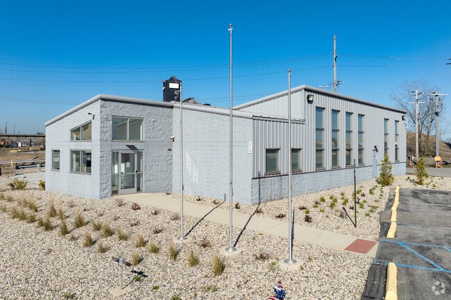
Property Record
219 Riley Rd, East Chicago, IN 46312


Current Lease Availabilities
NEARBY LISTINGS FOR SALE OR LEASE
Property Detail
219 Riley Rd
45-03-21-100-011.000-024
PART OF SEC 16, 17, 20, 21 T.37 R.9 (CLINE AVE BRIDGE) 37.5 AC
Taxexempt
Lake
AE
Indiana
18089C0039F
37.50 AC
2023
Indiana
2024
Chicago
030400
Chicago-Naperville-Elgin, IL-IN-WI
27,934 SF
DEMOGRAPHICS near 219 Riley Rd
1 Mile
3 Mile
5 Mile
2024 Total Population
895
45,192
129,827
2029 Population
914
44,394
127,505
Pop Growth 2024-2029
+ 2.12%
(1.77%)
(1.79%)
Average Age
37
37
38
2024 Total Households
314
16,958
47,347
HH Growth 2024-2029
+ 1.91%
(1.80%)
(1.92%)
Median Household Inc
$38,947
$44,816
$48,090
Avg Household Size
2.80
2.50
2.60
2024 Avg HH Vehicles
2.00
2.00
2.00
Median Home Value
$94,936
$119,989
$132,262
Median Year Built
1946
1947
1949
Nearby Places
Map Layers
Map Styles
 Street
 Aerial
- Restaurants
- Banks
- Shops
- Fitness
- Groceries
PUBLIC TRANSPORTATION
COMMUTER RAIL
DRIVE
WALK
Distance
8 min
4.2 mi
Hammond Station (South Shore Line - Northern Indiana Commuter Transportation District (South Shore Line))
DRIVE
WALK
Distance
Hammond Station (South Shore Line - Northern Indiana Commuter Transportation District (South Shore Line))
8 min
4.4 mi
AIRPORT
Chicago Midway International
DRIVE
WALK
Distance
Chicago Midway International
35 min
20.8 mi
Chicago O'Hare International
DRIVE
WALK
Distance
Chicago O'Hare International
57 min
37.8 mi
Nearby Properties
Address
Land Use
TOTAL SIZE
Lot Size
Zoning
Address
Land Use
TOTAL SIZE
Lot Size
Zoning
443,032 SF
R33
Address
Land Use
TOTAL SIZE
Lot Size
Zoning
791,664 SF
13.02 AC
Address
Land Use
TOTAL SIZE
Lot Size
Zoning
4,527,578 SF
716.50 AC
Address
Land Use
TOTAL SIZE
Lot Size
Zoning
215,444 SF
12.99 AC
Address
Land Use
TOTAL SIZE
Lot Size
Zoning
255,500 SF
14.30 AC
Address
Land Use
TOTAL SIZE
Lot Size
Zoning
2,157,270 SF
502.33 AC
Address
Land Use
TOTAL SIZE
Lot Size
Zoning
443,065 SF
36.69 AC
Address
Land Use
TOTAL SIZE
Lot Size
Zoning
5,180 SF
176.48 AC
Address
Land Use
TOTAL SIZE
Lot Size
Zoning
99,042 SF
255 AC
Address
Land Use
TOTAL SIZE
Lot Size
Zoning
303,132 SF
21.23 AC
Address
Land Use
TOTAL SIZE
Lot Size
Zoning
221,190 SF
109.74 AC
Address
Land Use
TOTAL SIZE
Lot Size
Zoning
2,618,087 SF
221.28 AC
Address
Land Use
TOTAL SIZE
Lot Size
Zoning
6,139 SF
78.90 AC
Address
Land Use
TOTAL SIZE
Lot Size
Zoning
244,773 SF
65.01 AC
Address
Land Use
TOTAL SIZE
Lot Size
Zoning
1,863,448 SF
393.05 AC
Address
Land Use
TOTAL SIZE
Lot Size
Zoning
16,644 SF
52.10 AC
Address
Land Use
TOTAL SIZE
Lot Size
Zoning
55,800 SF
7.25 AC
Address
Land Use
TOTAL SIZE
Lot Size
Zoning
126,900 SF
75.99 AC
Address
Land Use
TOTAL SIZE
Lot Size
Zoning
292,953 SF
8.93 AC
Address
Land Use
TOTAL SIZE
Lot Size
Zoning
68,885 SF
5.93 AC
Address
Land Use
TOTAL SIZE
Lot Size
Zoning
91,644 SF
29.28 AC
Address
Land Use
TOTAL SIZE
Lot Size
Zoning
484,604 SF
70.49 AC
Address
Land Use
TOTAL SIZE
Lot Size
Zoning
130,106 SF
12.16 AC
Address
Land Use
TOTAL SIZE
Lot Size
Zoning
261,928 SF
12.74 AC
Address
Land Use
TOTAL SIZE
Lot Size
Zoning
602,390 SF
217.85 AC
Address
Land Use
TOTAL SIZE
Lot Size
Zoning
119,200 SF
9.87 AC
Address
Land Use
TOTAL SIZE
Lot Size
Zoning
219,409 SF
89.21 AC
Address
Land Use
TOTAL SIZE
Lot Size
Zoning
600,448 SF
36.42 AC
Address
Land Use
TOTAL SIZE
Lot Size
Zoning
497,713 SF
31.43 AC
The World's #1 Commercial Real Estate Marketplace
Connect with us
© 2025 CoStar Group
The information above has been obtained from sources believed reliable. While we do not doubt its accuracy we have not verified it and make no guarantee, warranty or representation about it. It is your responsibility to independently confirm its accuracy and completeness. Any projections, opinions, assumptions, or estimates used are for example only and do not represent the current or future performance of the property. The value of this transaction to you depends on tax and other factors which should be evaluated by your tax, financial, and legal advisors. You and your advisors should conduct a careful, independent investigation of the property to determine to your satisfaction the suitability of the property for your needs.