Property Record
219 S 9Th St, Perkasie, PA 18944

Save to a Folder
{{folder.Name}}
{{folder.ListingIds.length}} Properties
{{folder.ListingIds.length}} Property
Create a New Folder
Property Detail
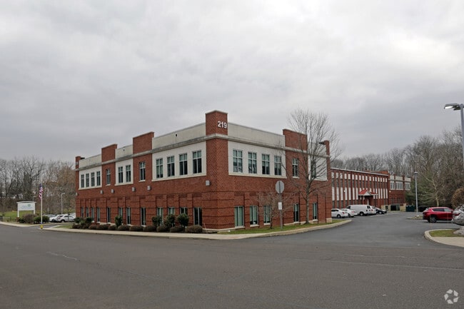
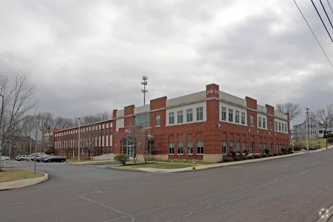
219 S 9Th St
33-005-024
S S 9TH ST 399 FT W OF CHESTNUT ST
Commercialnec
Bucks
I2
Pennsylvania
B and X Area of moderate flood hazard, usually the area between the limits of the 100-year and 500-year floods.
2.78 AC
2025
Upper Bucks County
2026
Philadelphia
102401
Philadelphia-Camden-Wilmington, PA-NJ-DE-MD
39,966 SF
NEARBY LISTINGS FOR SALE OR LEASE
DEMOGRAPHICS near 219 S 9Th St
1 mile
3 mile
5 mile
2025 Total Population
9,268
29,860
73,035
2030 Population
9,400
30,034
73,659
Pop Growth 2025-2030
+ 1.42%
+ 0.58%
+ 0.85%
Average Age
42
43
42
2025 Total Households
3,651
11,384
27,985
HH Growth 2025-2030
+ 1.37%
+ 0.54%
+ 0.82%
Median Household Inc
$99,192
$110,692
$103,770
Avg Household Size
2.50
2.60
2.60
2025 Avg HH Vehicles
2.00
2.00
2.00
Median Home Value
$374,354
$409,580
$403,533
Median Year Built
1969
1979
1976
Nearby Places
Map Layers
Map Styles
 Street
 Aerial
Layers
 Traffic
 Biking
Places
Listings with unknown addresses are not visible on the map
- Restaurants
- Banks
- Shops
- Fitness
- Groceries
PUBLIC TRANSPORTATION
COMMUTER RAIL
Link Belt (R5 - Southeastern Pennsylvania Transportation Authority Regional Rail (SEPTA Regional Rail))
Drive
Walk
Distance
Link Belt (R5 - Southeastern Pennsylvania Transportation Authority Regional Rail (SEPTA Regional Rail))
17 min
9.0 mi
Chalfont (R5 - Southeastern Pennsylvania Transportation Authority Regional Rail (SEPTA Regional Rail))
Drive
Walk
Distance
Chalfont (R5 - Southeastern Pennsylvania Transportation Authority Regional Rail (SEPTA Regional Rail))
18 min
9.0 mi
AIRPORT
Lehigh Valley International
Drive
Walk
Distance
Lehigh Valley International
44 min
25.3 mi
Trenton Mercer
Drive
Walk
Distance
Trenton Mercer
58 min
34.2 mi
Freight Ports
Port of Philadelphia
Drive
Walk
Distance
Port of Philadelphia
56 min
33.2 mi
Nearby Properties
Address
Land Use
TOTAL SIZE
Lot Size
Zoning
Address
Land Use
TOTAL SIZE
Lot Size
Zoning
98,397 SF
8.23 AC
LI
Address
Land Use
TOTAL SIZE
Lot Size
Zoning
256,512 SF
21.31 AC
CR
Address
Land Use
TOTAL SIZE
Lot Size
Zoning
205,462 SF
34.20 AC
PI
Address
Land Use
TOTAL SIZE
Lot Size
Zoning
1,261,187 SF
13.86 AC
CR
Address
Land Use
TOTAL SIZE
Lot Size
Zoning
92,018 SF
22.18 AC
I2
Address
Land Use
TOTAL SIZE
Lot Size
Zoning
29,166 SF
2.18 AC
LI
Address
Land Use
TOTAL SIZE
Lot Size
Zoning
27,500 SF
2.37 AC
LI
Address
Land Use
TOTAL SIZE
Lot Size
Zoning
213,419 SF
33.19 AC
PI
Address
Land Use
TOTAL SIZE
Lot Size
Zoning
131,218 SF
14.23 AC
PRD
Address
Land Use
TOTAL SIZE
Lot Size
Zoning
63,433 SF
8.20 AC
CO
Address
Land Use
TOTAL SIZE
Lot Size
Zoning
18,780 SF
2.45 AC
LI
Address
Land Use
TOTAL SIZE
Lot Size
Zoning
68,463 SF
10.86 AC
IS
Address
Land Use
TOTAL SIZE
Lot Size
Zoning
7.61 AC
CR
Address
Land Use
TOTAL SIZE
Lot Size
Zoning
37,444 SF
96.24 AC
PI
Address
Land Use
TOTAL SIZE
Lot Size
Zoning
105,840 SF
2.42 AC
R1B
Address
Land Use
TOTAL SIZE
Lot Size
Zoning
101,920 SF
21.05 AC
R1B
Address
Land Use
TOTAL SIZE
Lot Size
Zoning
98,213 SF
8.24 AC
LI
Address
Land Use
TOTAL SIZE
Lot Size
Zoning
40,000 SF
8.55 AC
I
Address
Land Use
TOTAL SIZE
Lot Size
Zoning
23,108 SF
7.91 AC
PI
Address
Land Use
TOTAL SIZE
Lot Size
Zoning
52,819 SF
15.35 AC
CR
Address
Land Use
TOTAL SIZE
Lot Size
Zoning
2,538 SF
4.96 AC
CR
Address
Land Use
TOTAL SIZE
Lot Size
Zoning
12,000 SF
128.21 AC
I1
Address
Land Use
TOTAL SIZE
Lot Size
Zoning
18,686 SF
15 AC
LI
Address
Land Use
TOTAL SIZE
Lot Size
Zoning
20,106 SF
6.49 AC
A
Address
Land Use
TOTAL SIZE
Lot Size
Zoning
80,383 SF
6.01 AC
PI
Address
Land Use
TOTAL SIZE
Lot Size
Zoning
37,500 SF
10.21 AC
LI
Address
Land Use
TOTAL SIZE
Lot Size
Zoning
45,118 SF
5.82 AC
PI
Address
Land Use
TOTAL SIZE
Lot Size
Zoning
37,263 SF
2 AC
PI
Address
Land Use
TOTAL SIZE
Lot Size
Zoning
31,012 SF
8.01 AC
PI
The World's #1 Commercial Real Estate Marketplace
Connect with us
© 2026 CoStar Group
The information above has been obtained from sources believed reliable. While we do not doubt its accuracy we have not verified it and make no guarantee, warranty or representation about it. It is your responsibility to independently confirm its accuracy and completeness. Any projections, opinions, assumptions, or estimates used are for example only and do not represent the current or future performance of the property. The value of this transaction to you depends on tax and other factors which should be evaluated by your tax, financial, and legal advisors. You and your advisors should conduct a careful, independent investigation of the property to determine to your satisfaction the suitability of the property for your needs.