Property Record
219 S Ohio Ave, Sedalia, MO 65301


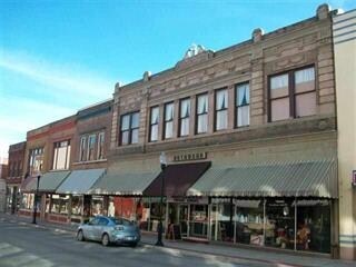
Property Detail
219 S Ohio Ave
Sedalia, MO
59' ACROSS MID PT LOTS 10, 11 & 12 BLK 46 ORIGINAL PLAT ADD
152004132008000
Pettis
Storebuilding
Missouri
2025
10-12
2025
0.19 AC
480900
Missouri North Area
13,940 SF
Other Market Areas
NEARBY LISTINGS FOR SALE OR LEASE
-
-
-
No Photo
-
-
-
-
View all Sedalia listings for sale on LoopNet.com
DEMOGRAPHICS near 219 S Ohio Ave
1 mile
3 mile
5 mile
2025 Total Population
10,158
26,407
31,599
2030 Population
10,414
26,895
32,132
Pop Growth 2025-2030
+ 2.52%
+ 1.85%
+ 1.69%
Average Age
37
39
39
2025 Total Households
3,978
10,666
12,526
HH Growth 2025-2030
+ 2.49%
+ 1.89%
+ 1.74%
Median Household Inc
$50,560
$54,942
$58,066
Avg Household Size
2.40
2.40
2.40
2025 Avg HH Vehicles
2.00
2.00
2.00
Median Home Value
$123,406
$157,690
$170,297
Median Year Built
1951
1966
1970
Nearby Places
Map Layers
Map Styles
 Street
 Aerial
Layers
 Traffic
 Biking
Places
Listings with unknown addresses are not visible on the map
- Restaurants
- Banks
- Shops
- Fitness
- Groceries
PUBLIC TRANSPORTATION
COMMUTER RAIL
Drive
Walk
Distance
1 min
5 min
0.3 mi
Nearby Properties
Address
Land Use
TOTAL SIZE
Lot Size
Zoning
Address
Land Use
TOTAL SIZE
Lot Size
Zoning
52,605 SF
26.56 AC
Address
Land Use
TOTAL SIZE
Lot Size
Zoning
201,452 SF
15 AC
Address
Land Use
TOTAL SIZE
Lot Size
Zoning
494,190 SF
45.23 AC
Address
Land Use
TOTAL SIZE
Lot Size
Zoning
121,591 SF
15.30 AC
Address
Land Use
TOTAL SIZE
Lot Size
Zoning
69,763 SF
9.96 AC
Address
Land Use
TOTAL SIZE
Lot Size
Zoning
440,184 SF
26 AC
Address
Land Use
TOTAL SIZE
Lot Size
Zoning
49,341 SF
3.37 AC
Address
Land Use
TOTAL SIZE
Lot Size
Zoning
3,060 SF
40.75 AC
Address
Land Use
TOTAL SIZE
Lot Size
Zoning
223,284 SF
38.25 AC
Address
Land Use
TOTAL SIZE
Lot Size
Zoning
13,158 SF
9.20 AC
Address
Land Use
TOTAL SIZE
Lot Size
Zoning
60,173 SF
3.85 AC
Address
Land Use
TOTAL SIZE
Lot Size
Zoning
11,149 SF
3.81 AC
Address
Land Use
TOTAL SIZE
Lot Size
Zoning
41,130 SF
2 AC
Address
Land Use
TOTAL SIZE
Lot Size
Zoning
8,699 SF
0.70 AC
Address
Land Use
TOTAL SIZE
Lot Size
Zoning
8,460 SF
1.90 AC
Address
Land Use
TOTAL SIZE
Lot Size
Zoning
18,000 SF
342.42 AC
Address
Land Use
TOTAL SIZE
Lot Size
Zoning
108,294 SF
12.31 AC
Address
Land Use
TOTAL SIZE
Lot Size
Zoning
8,700 SF
6.62 AC
Address
Land Use
TOTAL SIZE
Lot Size
Zoning
22,950 SF
3.34 AC
Address
Land Use
TOTAL SIZE
Lot Size
Zoning
91,564 SF
4.58 AC
Address
Land Use
TOTAL SIZE
Lot Size
Zoning
48,410 SF
1.84 AC
Address
Land Use
TOTAL SIZE
Lot Size
Zoning
52,400 SF
4.74 AC
Address
Land Use
TOTAL SIZE
Lot Size
Zoning
53,209 SF
3.29 AC
Address
Land Use
TOTAL SIZE
Lot Size
Zoning
3,816 SF
0.84 AC
Address
Land Use
TOTAL SIZE
Lot Size
Zoning
14,190 SF
1.58 AC
Address
Land Use
TOTAL SIZE
Lot Size
Zoning
41,054 SF
6.66 AC
Address
Land Use
TOTAL SIZE
Lot Size
Zoning
63,240 SF
6.12 AC
Address
Land Use
TOTAL SIZE
Lot Size
Zoning
32,640 SF
2.17 AC
Address
Land Use
TOTAL SIZE
Lot Size
Zoning
24,905 SF
4.13 AC
Address
Land Use
TOTAL SIZE
Lot Size
Zoning
30,000 SF
5.54 AC
The World's #1 Commercial Real Estate Marketplace
Connect with us
© 2026 CoStar Group
The information above has been obtained from sources believed reliable. While we do not doubt its accuracy we have not verified it and make no guarantee, warranty or representation about it. It is your responsibility to independently confirm its accuracy and completeness. Any projections, opinions, assumptions, or estimates used are for example only and do not represent the current or future performance of the property. The value of this transaction to you depends on tax and other factors which should be evaluated by your tax, financial, and legal advisors. You and your advisors should conduct a careful, independent investigation of the property to determine to your satisfaction the suitability of the property for your needs.