Property Record
219 Sugartown Rd, Wayne, PA 19087
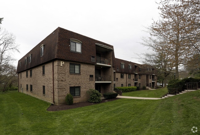


Property Detail
219 Sugartown Rd
36-06-03914-00
APT/COMPLEX/230-UNITS 17.16 ACRES +-
Apartment
Delaware
B and X Area of moderate flood hazard, usually the area between the limits of the 100-year and 500-year floods.
Pennsylvania
2026
17.16 AC
2026
Main Line-Delaware
409803
Philadelphia
6,210 SF
Philadelphia-Camden-Wilmington, PA-NJ-DE-MD
NEARBY LISTINGS FOR SALE OR LEASE
-
-
View all Wayne listings for sale on LoopNet.com
DEMOGRAPHICS near 219 Sugartown Rd
1 mile
3 mile
5 mile
2025 Total Population
12,586
56,328
150,306
2030 Population
13,316
58,441
154,620
Pop Growth 2025-2030
+ 5.80%
+ 3.75%
+ 2.87%
Average Age
39
40
41
2025 Total Households
4,837
20,742
57,112
HH Growth 2025-2030
+ 6.04%
+ 4.05%
+ 3.05%
Median Household Inc
$145,128
$171,617
$135,119
Avg Household Size
2.60
2.50
2.40
2025 Avg HH Vehicles
2.00
2.00
2.00
Median Home Value
$761,659
$802,616
$686,332
Median Year Built
1970
1969
1969
Nearby Places
Map Layers
Map Styles
 Street
 Aerial
Layers
 Traffic
 Biking
Places
Listings with unknown addresses are not visible on the map
- Restaurants
- Banks
- Shops
- Fitness
- Groceries
PUBLIC TRANSPORTATION
COMMUTER RAIL
Strafford (R5 - Southeastern Pennsylvania Transportation Authority Regional Rail (SEPTA Regional Rail))
Drive
Walk
Distance
Strafford (R5 - Southeastern Pennsylvania Transportation Authority Regional Rail (SEPTA Regional Rail))
2 min
10 min
0.5 mi
Devon (R5 - Southeastern Pennsylvania Transportation Authority Regional Rail (SEPTA Regional Rail))
Drive
Walk
Distance
Devon (R5 - Southeastern Pennsylvania Transportation Authority Regional Rail (SEPTA Regional Rail))
4 min
1.5 mi
AIRPORT
Philadelphia International
Drive
Walk
Distance
Philadelphia International
36 min
21.8 mi
Freight Ports
South Jersey Port
Drive
Walk
Distance
South Jersey Port
39 min
25.3 mi
Nearby Properties
Address
Land Use
TOTAL SIZE
Lot Size
Zoning
Address
Land Use
TOTAL SIZE
Lot Size
Zoning
10.50 AC
Address
Land Use
TOTAL SIZE
Lot Size
Zoning
192,800 SF
129.66 AC
Address
Land Use
TOTAL SIZE
Lot Size
Zoning
222,980 SF
57.68 AC
Address
Land Use
TOTAL SIZE
Lot Size
Zoning
398,844 SF
21.89 AC
Address
Land Use
TOTAL SIZE
Lot Size
Zoning
45,871 SF
112 AC
Address
Land Use
TOTAL SIZE
Lot Size
Zoning
628,694 SF
6.89 AC
AG
Address
Land Use
TOTAL SIZE
Lot Size
Zoning
649,339 SF
3.69 AC
AG
Address
Land Use
TOTAL SIZE
Lot Size
Zoning
254,781 SF
14.62 AC
Address
Land Use
TOTAL SIZE
Lot Size
Zoning
325,016 SF
1.62 AC
P
Address
Land Use
TOTAL SIZE
Lot Size
Zoning
137,282 SF
14.33 AC
Address
Land Use
TOTAL SIZE
Lot Size
Zoning
546,664 SF
2.83 AC
AG
Address
Land Use
TOTAL SIZE
Lot Size
Zoning
547,377 SF
3.28 AC
AG
Address
Land Use
TOTAL SIZE
Lot Size
Zoning
92,337 SF
7.30 AC
Address
Land Use
TOTAL SIZE
Lot Size
Zoning
583,559 SF
AG
Address
Land Use
TOTAL SIZE
Lot Size
Zoning
451,865 SF
19.90 AC
R2
Address
Land Use
TOTAL SIZE
Lot Size
Zoning
260,938 SF
9.81 AC
SM1
Address
Land Use
TOTAL SIZE
Lot Size
Zoning
311,353 SF
7.41 AC
SM1
Address
Land Use
TOTAL SIZE
Lot Size
Zoning
414,642 SF
3.70 AC
AG
Address
Land Use
TOTAL SIZE
Lot Size
Zoning
63,648 SF
8.60 AC
C2
Address
Land Use
TOTAL SIZE
Lot Size
Zoning
322,236 SF
50.80 AC
Address
Land Use
TOTAL SIZE
Lot Size
Zoning
322,736 SF
22 AC
LI
Address
Land Use
TOTAL SIZE
Lot Size
Zoning
30,787 SF
30.50 AC
Address
Land Use
TOTAL SIZE
Lot Size
Zoning
114,121 SF
16.80 AC
LI
Address
Land Use
TOTAL SIZE
Lot Size
Zoning
29,364 SF
21.90 AC
Address
Land Use
TOTAL SIZE
Lot Size
Zoning
193,290 SF
8.34 AC
Address
Land Use
TOTAL SIZE
Lot Size
Zoning
33,000 SF
1 AC
Address
Land Use
TOTAL SIZE
Lot Size
Zoning
799,754 SF
27.10 AC
R4
Address
Land Use
TOTAL SIZE
Lot Size
Zoning
159,248 SF
23.13 AC
Address
Land Use
TOTAL SIZE
Lot Size
Zoning
123,862 SF
12.97 AC
AG
The World's #1 Commercial Real Estate Marketplace
Connect with us
© 2026 CoStar Group
The information above has been obtained from sources believed reliable. While we do not doubt its accuracy we have not verified it and make no guarantee, warranty or representation about it. It is your responsibility to independently confirm its accuracy and completeness. Any projections, opinions, assumptions, or estimates used are for example only and do not represent the current or future performance of the property. The value of this transaction to you depends on tax and other factors which should be evaluated by your tax, financial, and legal advisors. You and your advisors should conduct a careful, independent investigation of the property to determine to your satisfaction the suitability of the property for your needs.