Property Record
219 Superior Dr, Evanston, WY 82930
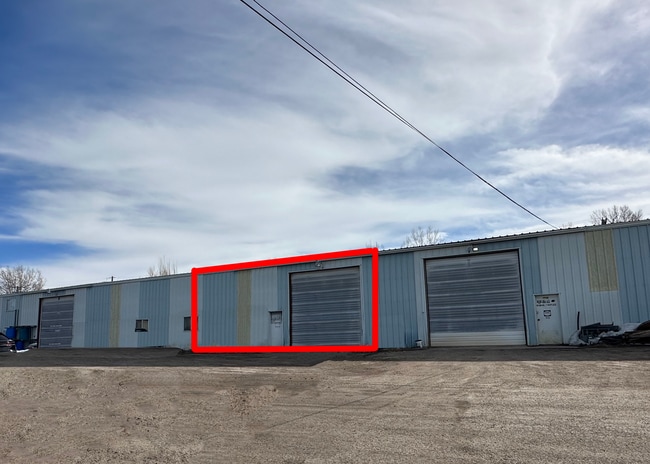
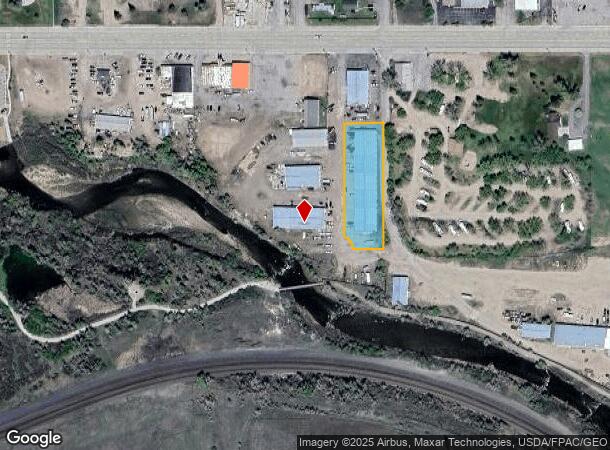
Property Detail
219 Superior Dr
Evanston, WY-UT
Zumbrennen Light Industrial Park
R0004379
ZUMBRENNEN LIGHT IND PARK LTS 2,3 & 4
Autorepair
Uinta
X
Wyoming
56041C0489C
2,3&4
2024
0.95 AC
2025
I-80 Corridor/Cheyenne
975402
Other Market Areas
18,000 SF
NEARBY LISTINGS FOR SALE OR LEASE
DEMOGRAPHICS near 219 Superior Dr
1 mile
3 mile
5 mile
2024 Total Population
2,546
13,114
13,619
2029 Population
2,703
13,681
14,194
Pop Growth 2024-2029
+ 6.17%
+ 4.32%
+ 4.22%
Average Age
39
37
37
2024 Total Households
1,046
5,028
5,212
HH Growth 2024-2029
+ 6.02%
+ 4.24%
+ 4.13%
Median Household Inc
$59,341
$66,415
$66,706
Avg Household Size
2.30
2.50
2.50
2024 Avg HH Vehicles
2.00
2.00
2.00
Median Home Value
$140,244
$183,581
$184,167
Median Year Built
1975
1982
1982
Nearby Places
Map Layers
Map Styles
 Street
 Aerial
Transit
 Traffic
 Biking
Places
Listings with unknown addresses are not visible on the map
- Restaurants
- Banks
- Shops
- Fitness
- Groceries
SALE & LEASE HISTORY
LISTING DATE
SALE/LEASE

Apr 26, 2023
For Lease
Nearby Properties
Address
Land Use
TOTAL SIZE
Lot Size
Zoning
Address
Land Use
TOTAL SIZE
Lot Size
Zoning
154.18 AC
Address
Land Use
TOTAL SIZE
Lot Size
Zoning
165,417 SF
16.36 AC
Address
Land Use
TOTAL SIZE
Lot Size
Zoning
2,596 SF
3.51 AC
Address
Land Use
TOTAL SIZE
Lot Size
Zoning
1,428 SF
4.71 AC
Address
Land Use
TOTAL SIZE
Lot Size
Zoning
79,438 SF
5 AC
Address
Land Use
TOTAL SIZE
Lot Size
Zoning
118,542 SF
5.91 AC
Address
Land Use
TOTAL SIZE
Lot Size
Zoning
69,131 SF
7.74 AC
Address
Land Use
TOTAL SIZE
Lot Size
Zoning
58,721 SF
7.13 AC
Address
Land Use
TOTAL SIZE
Lot Size
Zoning
98,088 SF
3.70 AC
Address
Land Use
TOTAL SIZE
Lot Size
Zoning
1,328 SF
8.69 AC
Address
Land Use
TOTAL SIZE
Lot Size
Zoning
70,500 SF
8.03 AC
Address
Land Use
TOTAL SIZE
Lot Size
Zoning
62,682 SF
11.13 AC
Address
Land Use
TOTAL SIZE
Lot Size
Zoning
33,948 SF
1.51 AC
Address
Land Use
TOTAL SIZE
Lot Size
Zoning
21,463 SF
0.61 AC
Address
Land Use
TOTAL SIZE
Lot Size
Zoning
36,480 SF
0.28 AC
Address
Land Use
TOTAL SIZE
Lot Size
Zoning
988 SF
3.11 AC
Address
Land Use
TOTAL SIZE
Lot Size
Zoning
51,569 SF
3.80 AC
Address
Land Use
TOTAL SIZE
Lot Size
Zoning
61,180 SF
4.05 AC
Address
Land Use
TOTAL SIZE
Lot Size
Zoning
62,370 SF
2.72 AC
Address
Land Use
TOTAL SIZE
Lot Size
Zoning
18,737 SF
3.33 AC
Address
Land Use
TOTAL SIZE
Lot Size
Zoning
69,146 SF
6.54 AC
Address
Land Use
TOTAL SIZE
Lot Size
Zoning
32,820 SF
0.26 AC
Address
Land Use
TOTAL SIZE
Lot Size
Zoning
47,260 SF
2.06 AC
Address
Land Use
TOTAL SIZE
Lot Size
Zoning
27,880 SF
5 AC
Address
Land Use
TOTAL SIZE
Lot Size
Zoning
7,762 SF
0.58 AC
Address
Land Use
TOTAL SIZE
Lot Size
Zoning
99.74 AC
Address
Land Use
TOTAL SIZE
Lot Size
Zoning
36,552 SF
4.40 AC
Address
Land Use
TOTAL SIZE
Lot Size
Zoning
28,966 SF
1.76 AC
Address
Land Use
TOTAL SIZE
Lot Size
Zoning
50,200 SF
2.92 AC
Address
Land Use
TOTAL SIZE
Lot Size
Zoning
25,886 SF
1.52 AC
The World's #1 Commercial Real Estate Marketplace
Connect with us
© 2026 CoStar Group
The information above has been obtained from sources believed reliable. While we do not doubt its accuracy we have not verified it and make no guarantee, warranty or representation about it. It is your responsibility to independently confirm its accuracy and completeness. Any projections, opinions, assumptions, or estimates used are for example only and do not represent the current or future performance of the property. The value of this transaction to you depends on tax and other factors which should be evaluated by your tax, financial, and legal advisors. You and your advisors should conduct a careful, independent investigation of the property to determine to your satisfaction the suitability of the property for your needs.