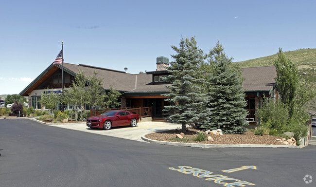
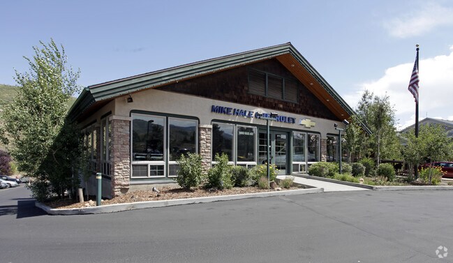
Property Record
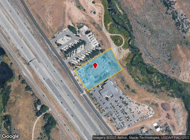
2190 Rasmussen Rd, Park City, UT 84098
NEARBY LISTINGS FOR SALE OR LEASE
Property Detail
2190 Rasmussen Rd
PP-52-A
Pp # South Of I-80
Commercialbuilding
BEG AT A PT WH IS S 2018.187 FT & W 1145.69 FT FROM THE NE COR SEC 13 T1SR3E SLBM; TH N 34*3313 W ALONG ST HWY R/W83.37 FT; TH N 31*5638 W ALONG ST HWY R/W 151.23 FT; TH N 58*3927 E 406.85 FT; TH S 28*2406 E 212.45 FT; TH S 37* 30 E 22.42 FT; TH S 58
X
Summit
49035C0375G
Utah
2025
2.15 AC
2025
Summit County
964306
Salt Lake City
20,109 SF
Summit Park, UT
DEMOGRAPHICS near 2190 Rasmussen Rd
1 Mile
3 Mile
5 Mile
2024 Total Population
1,846
15,859
23,729
2029 Population
1,954
16,671
25,292
Pop Growth 2024-2029
+ 5.85%
+ 5.12%
+ 6.59%
Average Age
37
39
40
2024 Total Households
768
5,954
8,903
HH Growth 2024-2029
+ 5.34%
+ 4.43%
+ 6.01%
Median Household Inc
$82,799
$164,707
$159,026
Avg Household Size
2.40
2.60
2.60
2024 Avg HH Vehicles
2.00
2.00
2.00
Median Home Value
$854,687
$862,442
$902,033
Median Year Built
1997
1997
1997
Nearby Places
Map Layers
Map Styles
 Street
 Aerial
- Restaurants
- Banks
- Shops
- Fitness
- Groceries
PUBLIC TRANSPORTATION
AIRPORT
Salt Lake City International
DRIVE
WALK
Distance
Salt Lake City International
37 min
29.3 mi
Nearby Properties
Address
Land Use
TOTAL SIZE
Lot Size
Zoning
Address
Land Use
TOTAL SIZE
Lot Size
Zoning
322,804 SF
37.32 AC
Address
Land Use
TOTAL SIZE
Lot Size
Zoning
74,233 SF
6.89 AC
Address
Land Use
TOTAL SIZE
Lot Size
Zoning
40,694 SF
8.42 AC
Address
Land Use
TOTAL SIZE
Lot Size
Zoning
70,603 SF
5.86 AC
Address
Land Use
TOTAL SIZE
Lot Size
Zoning
90,911 SF
1.88 AC
Address
Land Use
TOTAL SIZE
Lot Size
Zoning
68,248 SF
7.42 AC
Address
Land Use
TOTAL SIZE
Lot Size
Zoning
74,543 SF
3.45 AC
Address
Land Use
TOTAL SIZE
Lot Size
Zoning
48,092 SF
2.28 AC
Address
Land Use
TOTAL SIZE
Lot Size
Zoning
55,447 SF
1.88 AC
Address
Land Use
TOTAL SIZE
Lot Size
Zoning
203.47 AC
Address
Land Use
TOTAL SIZE
Lot Size
Zoning
54,133 SF
1.97 AC
Address
Land Use
TOTAL SIZE
Lot Size
Zoning
0.55 AC
Address
Land Use
TOTAL SIZE
Lot Size
Zoning
49,257 SF
1.67 AC
Address
Land Use
TOTAL SIZE
Lot Size
Zoning
47,044 SF
7.38 AC
Address
Land Use
TOTAL SIZE
Lot Size
Zoning
110,109 SF
7.05 AC
Address
Land Use
TOTAL SIZE
Lot Size
Zoning
50,913 SF
5.03 AC
Address
Land Use
TOTAL SIZE
Lot Size
Zoning
49,530 SF
2.43 AC
Address
Land Use
TOTAL SIZE
Lot Size
Zoning
115,767 SF
9.82 AC
Address
Land Use
TOTAL SIZE
Lot Size
Zoning
54,657 SF
5.20 AC
Address
Land Use
TOTAL SIZE
Lot Size
Zoning
53,948 SF
126.39 AC
Address
Land Use
TOTAL SIZE
Lot Size
Zoning
14,903 SF
4 AC
Address
Land Use
TOTAL SIZE
Lot Size
Zoning
Address
Land Use
TOTAL SIZE
Lot Size
Zoning
39,080 SF
3.28 AC
Address
Land Use
TOTAL SIZE
Lot Size
Zoning
23,201 SF
60 AC
Address
Land Use
TOTAL SIZE
Lot Size
Zoning
34,119 SF
1.39 AC
Address
Land Use
TOTAL SIZE
Lot Size
Zoning
39,601 SF
2.20 AC
Address
Land Use
TOTAL SIZE
Lot Size
Zoning
83,000 SF
2.37 AC
Address
Land Use
TOTAL SIZE
Lot Size
Zoning
27,508 SF
0.96 AC
The World's #1 Commercial Real Estate Marketplace
Connect with us
© 2026 CoStar Group
The information above has been obtained from sources believed reliable. While we do not doubt its accuracy we have not verified it and make no guarantee, warranty or representation about it. It is your responsibility to independently confirm its accuracy and completeness. Any projections, opinions, assumptions, or estimates used are for example only and do not represent the current or future performance of the property. The value of this transaction to you depends on tax and other factors which should be evaluated by your tax, financial, and legal advisors. You and your advisors should conduct a careful, independent investigation of the property to determine to your satisfaction the suitability of the property for your needs.