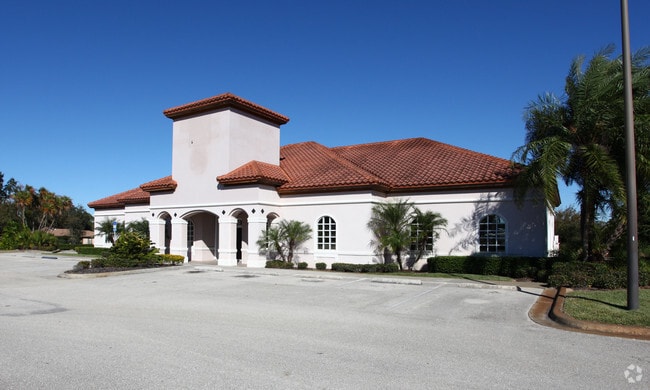
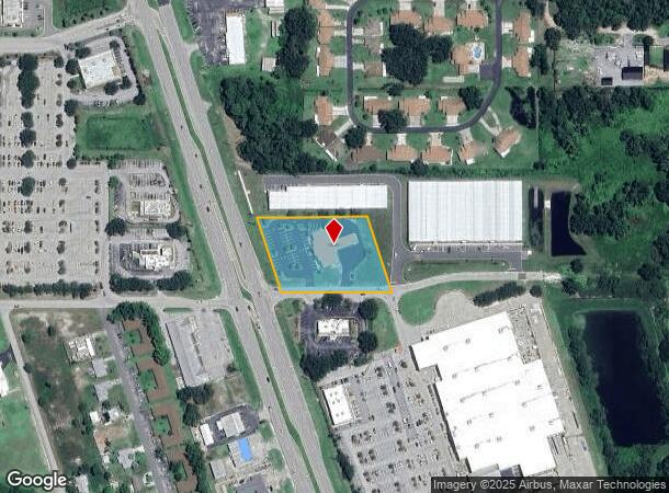
Property Record
2190 Us Highway 27 N, Sebring, FL 33870

NEARBY LISTINGS FOR SALE OR LEASE
Property Detail
2190 Us Highway 27 N
C-23-34-28-A00-0400-0000
Sun N Lakes Estates Of Sebring
Officebuilding
A 1.91 ACRE TR BEING 250 FT ALONG ELY R/W US 27 IN S 1/4 OF SEC 23 23-34-28/40 1.91 ACRES
X
Highlands
12055C0138C
Florida
0
1.91 AC
2025
Florida Central South Area
960700
Other Market Areas
7,980 SF
Sebring, FL
DEMOGRAPHICS near 2190 Us Highway 27 N
1 Mile
3 Mile
5 Mile
2024 Total Population
5,231
26,883
48,749
2029 Population
5,618
29,215
53,168
Pop Growth 2024-2029
+ 7.40%
+ 8.67%
+ 9.06%
Average Age
51
51
50
2024 Total Households
2,425
12,260
21,933
HH Growth 2024-2029
+ 7.55%
+ 8.81%
+ 9.21%
Median Household Inc
$51,230
$55,008
$51,057
Avg Household Size
2.10
2.10
2.10
2024 Avg HH Vehicles
2.00
2.00
2.00
Median Home Value
$152,296
$144,690
$152,086
Median Year Built
1982
1985
1985
Nearby Places
Map Layers
Map Styles
 Street
 Aerial
- Restaurants
- Banks
- Shops
- Fitness
- Groceries
PUBLIC TRANSPORTATION
COMMUTER RAIL
Sebring Amtrak Station (Silver Meteor - Amtrak, Silver Star - Amtrak)
DRIVE
WALK
Distance
Sebring Amtrak Station (Silver Meteor - Amtrak, Silver Star - Amtrak)
11 min
5.1 mi
Freight Ports
Port of Tampa Bay
DRIVE
WALK
Distance
Port of Tampa Bay
119 min
85.6 mi
Nearby Properties
Address
Land Use
TOTAL SIZE
Lot Size
Zoning
Address
Land Use
TOTAL SIZE
Lot Size
Zoning
319,284 SF
76.37 AC
P
Address
Land Use
TOTAL SIZE
Lot Size
Zoning
235,165 SF
33.99 AC
B3
Address
Land Use
TOTAL SIZE
Lot Size
Zoning
155,486 SF
21.71 AC
C1
Address
Land Use
TOTAL SIZE
Lot Size
Zoning
118,053 SF
21.01 AC
P
Address
Land Use
TOTAL SIZE
Lot Size
Zoning
91,625 SF
5 AC
R3
Address
Land Use
TOTAL SIZE
Lot Size
Zoning
176,175 SF
22.73 AC
C1
Address
Land Use
TOTAL SIZE
Lot Size
Zoning
104,876 SF
33.52 AC
B3
Address
Land Use
TOTAL SIZE
Lot Size
Zoning
62,304 SF
6.18 AC
B3
Address
Land Use
TOTAL SIZE
Lot Size
Zoning
320 SF
10.93 AC
C1
Address
Land Use
TOTAL SIZE
Lot Size
Zoning
58,228 SF
2.64 AC
C1
Address
Land Use
TOTAL SIZE
Lot Size
Zoning
41,224 SF
2.16 AC
C1
Address
Land Use
TOTAL SIZE
Lot Size
Zoning
23,187 SF
0.68 AC
P
Address
Land Use
TOTAL SIZE
Lot Size
Zoning
137,240 SF
14.46 AC
B3
Address
Land Use
TOTAL SIZE
Lot Size
Zoning
81,888 SF
4.80 AC
C1
Address
Land Use
TOTAL SIZE
Lot Size
Zoning
119,540 SF
15.17 AC
B3
Address
Land Use
TOTAL SIZE
Lot Size
Zoning
73,229 SF
14.19 AC
PU
Address
Land Use
TOTAL SIZE
Lot Size
Zoning
71,609 SF
15.32 AC
P
Address
Land Use
TOTAL SIZE
Lot Size
Zoning
46,625 SF
6.45 AC
R3FUD
Address
Land Use
TOTAL SIZE
Lot Size
Zoning
39,144 SF
1.67 AC
C1
Address
Land Use
TOTAL SIZE
Lot Size
Zoning
40,085 SF
9.72 AC
R3FUD
Address
Land Use
TOTAL SIZE
Lot Size
Zoning
102,610 SF
5.06 AC
C1
Address
Land Use
TOTAL SIZE
Lot Size
Zoning
31,806 SF
6 AC
R3
Address
Land Use
TOTAL SIZE
Lot Size
Zoning
55,344 SF
8.15 AC
C1
Address
Land Use
TOTAL SIZE
Lot Size
Zoning
388,414 SF
49.99 AC
B4FUD
Address
Land Use
TOTAL SIZE
Lot Size
Zoning
26,587 SF
1.80 AC
B3
Address
Land Use
TOTAL SIZE
Lot Size
Zoning
68,140 SF
6.66 AC
B3
Address
Land Use
TOTAL SIZE
Lot Size
Zoning
28,628 SF
4.22 AC
B3
Address
Land Use
TOTAL SIZE
Lot Size
Zoning
17,006 SF
2.59 AC
B2
Address
Land Use
TOTAL SIZE
Lot Size
Zoning
22,340 SF
2.22 AC
C1
Address
Land Use
TOTAL SIZE
Lot Size
Zoning
29,041 SF
1.39 AC
B2CU
The World's #1 Commercial Real Estate Marketplace
Connect with us
© 2025 CoStar Group
The information above has been obtained from sources believed reliable. While we do not doubt its accuracy we have not verified it and make no guarantee, warranty or representation about it. It is your responsibility to independently confirm its accuracy and completeness. Any projections, opinions, assumptions, or estimates used are for example only and do not represent the current or future performance of the property. The value of this transaction to you depends on tax and other factors which should be evaluated by your tax, financial, and legal advisors. You and your advisors should conduct a careful, independent investigation of the property to determine to your satisfaction the suitability of the property for your needs.