Property Record
21900 E 96Th St S, Broken Arrow, OK 74014
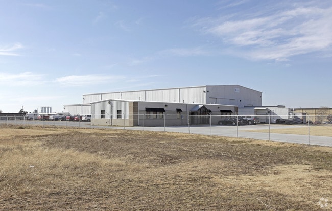

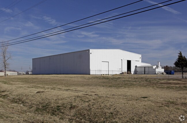
Property Detail
21900 E 96Th St S
730005761
20-18-15 BEG AT THE CENTER OF SEC 20 -E 660' TO POB-S 726'- E 660'- N 726'- W 660' TO POB BK 1084 PG 327 (BA CITY ANNEX-CITY)
Officebuilding
Wagoner
B and X Area of moderate flood hazard, usually the area between the limits of the 100-year and 500-year floods.
Oklahoma
2025
11 AC
2025
Wagoner County
030502
Tulsa
3,500 SF
Tulsa, OK
NEARBY LISTINGS FOR SALE OR LEASE
DEMOGRAPHICS near 21900 E 96Th St S
1 mile
3 mile
5 mile
2025 Total Population
2,161
23,571
88,638
2030 Population
2,382
25,653
93,915
Pop Growth 2025-2030
+ 10.23%
+ 8.83%
+ 5.95%
Average Age
41
40
39
2025 Total Households
772
8,516
33,621
HH Growth 2025-2030
+ 9.84%
+ 8.55%
+ 5.76%
Median Household Inc
$102,583
$98,951
$83,421
Avg Household Size
2.70
2.70
2.60
2025 Avg HH Vehicles
3.00
2.00
2.00
Median Home Value
$300,291
$288,232
$254,200
Median Year Built
1994
2000
1989
Nearby Places
Map Layers
Map Styles
 Street
 Aerial
Layers
 Traffic
 Biking
Places
Listings with unknown addresses are not visible on the map
- Restaurants
- Banks
- Shops
- Fitness
- Groceries
PUBLIC TRANSPORTATION
AIRPORT
Tulsa International
Drive
Walk
Distance
Tulsa International
28 min
20.3 mi
Freight Ports
Drive
Walk
Distance
28 min
16.2 mi
Nearby Properties
Address
Land Use
TOTAL SIZE
Lot Size
Zoning
Address
Land Use
TOTAL SIZE
Lot Size
Zoning
10,140 SF
18.57 AC
R1
Address
Land Use
TOTAL SIZE
Lot Size
Zoning
11,800 SF
2.45 AC
A1
Address
Land Use
TOTAL SIZE
Lot Size
Zoning
255,328 SF
27.50 AC
IL
Address
Land Use
TOTAL SIZE
Lot Size
Zoning
Address
Land Use
TOTAL SIZE
Lot Size
Zoning
5,920 SF
10.77 AC
Address
Land Use
TOTAL SIZE
Lot Size
Zoning
18,820 SF
13.42 AC
Address
Land Use
TOTAL SIZE
Lot Size
Zoning
7,200 SF
24.37 AC
Address
Land Use
TOTAL SIZE
Lot Size
Zoning
183,055 SF
35.44 AC
IL
Address
Land Use
TOTAL SIZE
Lot Size
Zoning
40,560 SF
14.96 AC
Address
Land Use
TOTAL SIZE
Lot Size
Zoning
14,625 SF
42.36 AC
Address
Land Use
TOTAL SIZE
Lot Size
Zoning
9,561 SF
2.83 AC
R1
Address
Land Use
TOTAL SIZE
Lot Size
Zoning
11.34 AC
A1
Address
Land Use
TOTAL SIZE
Lot Size
Zoning
Address
Land Use
TOTAL SIZE
Lot Size
Zoning
6,985 SF
0.62 AC
IL
Address
Land Use
TOTAL SIZE
Lot Size
Zoning
12,335 SF
4.62 AC
A1
Address
Land Use
TOTAL SIZE
Lot Size
Zoning
152,100 SF
10.06 AC
IL
Address
Land Use
TOTAL SIZE
Lot Size
Zoning
11,220 SF
8.58 AC
Address
Land Use
TOTAL SIZE
Lot Size
Zoning
319 SF
8.23 AC
Address
Land Use
TOTAL SIZE
Lot Size
Zoning
810 SF
56.20 AC
Address
Land Use
TOTAL SIZE
Lot Size
Zoning
2,275 SF
0.28 AC
Address
Land Use
TOTAL SIZE
Lot Size
Zoning
108,838 SF
4.62 AC
IH
Address
Land Use
TOTAL SIZE
Lot Size
Zoning
5,640 SF
1.20 AC
Address
Land Use
TOTAL SIZE
Lot Size
Zoning
16,790 SF
2.82 AC
Address
Land Use
TOTAL SIZE
Lot Size
Zoning
2,000 SF
1.55 AC
Address
Land Use
TOTAL SIZE
Lot Size
Zoning
10,000 SF
3 AC
Address
Land Use
TOTAL SIZE
Lot Size
Zoning
6,072 SF
1.74 AC
AGR
Address
Land Use
TOTAL SIZE
Lot Size
Zoning
2,679 SF
2.52 AC
AG
Address
Land Use
TOTAL SIZE
Lot Size
Zoning
9,250 SF
6.89 AC
Address
Land Use
TOTAL SIZE
Lot Size
Zoning
1,500 SF
0.78 AC
Address
Land Use
TOTAL SIZE
Lot Size
Zoning
3,574 SF
0.16 AC
The World's #1 Commercial Real Estate Marketplace
Connect with us
© 2026 CoStar Group
The information above has been obtained from sources believed reliable. While we do not doubt its accuracy we have not verified it and make no guarantee, warranty or representation about it. It is your responsibility to independently confirm its accuracy and completeness. Any projections, opinions, assumptions, or estimates used are for example only and do not represent the current or future performance of the property. The value of this transaction to you depends on tax and other factors which should be evaluated by your tax, financial, and legal advisors. You and your advisors should conduct a careful, independent investigation of the property to determine to your satisfaction the suitability of the property for your needs.