Property Record
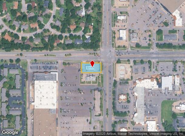
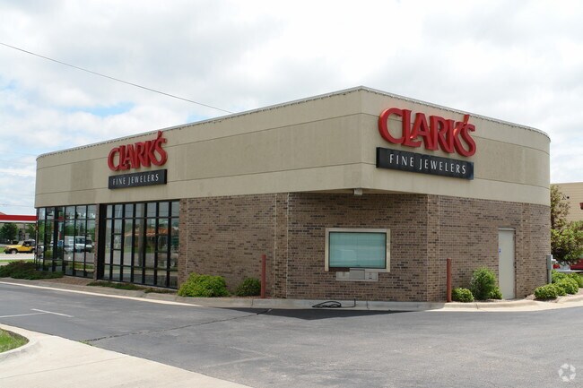
2191 N Rock Rd, Wichita, KS 67206

NEARBY LISTINGS FOR SALE OR LEASE
Property Detail
2191 N Rock Rd
Wichita, KS
E E Jabes Addition
113-07-0-11-01-001.00
PT LOT 1 BEG NE COR S 100 FT W 200 FT TO W LI N 103.75 FT TO NW COR SE 25.26 FT E 175 FT TO BEG BLOCK 1E. E. JABES ADD.
Restaurantdrivein
Sedgwick
X
Kansas
20173C0376G
1
2024
0.46 AC
2025
Northeast
010109
Wichita
3,634 SF
DEMOGRAPHICS near 2191 N Rock Rd
1 Mile
3 Mile
5 Mile
2024 Total Population
7,430
59,309
153,483
2029 Population
7,546
60,189
156,811
Pop Growth 2024-2029
+ 1.56%
+ 1.48%
+ 2.17%
Average Age
44
39
38
2024 Total Households
3,534
24,536
62,363
HH Growth 2024-2029
+ 1.50%
+ 1.37%
+ 2.08%
Median Household Inc
$59,888
$68,465
$59,842
Avg Household Size
2.00
2.30
2.30
2024 Avg HH Vehicles
2.00
2.00
2.00
Median Home Value
$270,036
$224,950
$185,749
Median Year Built
1983
1980
1975
Nearby Places
Map Layers
Map Styles
 Street
 Aerial
- Restaurants
- Banks
- Shops
- Fitness
- Groceries
PUBLIC TRANSPORTATION
AIRPORT
Wichita Dwight D Eisenhower Ntl
DRIVE
WALK
Distance
Wichita Dwight D Eisenhower Ntl
24 min
14.6 mi
Nearby Properties
Address
Land Use
TOTAL SIZE
Lot Size
Zoning
Address
Land Use
TOTAL SIZE
Lot Size
Zoning
481,160 SF
63.37 AC
SF-5
Address
Land Use
TOTAL SIZE
Lot Size
Zoning
346,728 SF
15.91 AC
SF-5
Address
Land Use
TOTAL SIZE
Lot Size
Zoning
340,322 SF
32.82 AC
SF-5,B
Address
Land Use
TOTAL SIZE
Lot Size
Zoning
243,768 SF
5.42 AC
LI
Address
Land Use
TOTAL SIZE
Lot Size
Zoning
366,272 SF
332.54 AC
LI
Address
Land Use
TOTAL SIZE
Lot Size
Zoning
148,617 SF
17.27 AC
SF-5
Address
Land Use
TOTAL SIZE
Lot Size
Zoning
104,331 SF
SF-5
Address
Land Use
TOTAL SIZE
Lot Size
Zoning
103,261 SF
5.49 AC
B
Address
Land Use
TOTAL SIZE
Lot Size
Zoning
204,778 SF
24.53 AC
SF-5
Address
Land Use
TOTAL SIZE
Lot Size
Zoning
186,902 SF
5.24 AC
SF-5
Address
Land Use
TOTAL SIZE
Lot Size
Zoning
169,134 SF
18.97 AC
SF-5
Address
Land Use
TOTAL SIZE
Lot Size
Zoning
199,468 SF
24.45 AC
SF-5
Address
Land Use
TOTAL SIZE
Lot Size
Zoning
73,314 SF
3.18 AC
SF-5
Address
Land Use
TOTAL SIZE
Lot Size
Zoning
69,125 SF
16.79 AC
MF-29,MF-1
Address
Land Use
TOTAL SIZE
Lot Size
Zoning
138,233 SF
23.01 AC
SF-5
Address
Land Use
TOTAL SIZE
Lot Size
Zoning
136,627 SF
27.46 AC
SF-5
Address
Land Use
TOTAL SIZE
Lot Size
Zoning
88,652 SF
21.92 AC
SF-5
Address
Land Use
TOTAL SIZE
Lot Size
Zoning
146,863 SF
14.24 AC
SF-5
Address
Land Use
TOTAL SIZE
Lot Size
Zoning
74,242 SF
23.99 AC
GC
Address
Land Use
TOTAL SIZE
Lot Size
Zoning
67,067 SF
8.36 AC
SF-5
Address
Land Use
TOTAL SIZE
Lot Size
Zoning
111,805 SF
20.09 AC
SF-5
Address
Land Use
TOTAL SIZE
Lot Size
Zoning
84,452 SF
0.46 AC
B
Address
Land Use
TOTAL SIZE
Lot Size
Zoning
99,325 SF
17.83 AC
SF-5
Address
Land Use
TOTAL SIZE
Lot Size
Zoning
74,265 SF
15.01 AC
LC
Address
Land Use
TOTAL SIZE
Lot Size
Zoning
41,526 SF
17.52 AC
LC
Address
Land Use
TOTAL SIZE
Lot Size
Zoning
121,541 SF
47.63 AC
LI
Address
Land Use
TOTAL SIZE
Lot Size
Zoning
728,346 SF
33.17 AC
LC
Address
Land Use
TOTAL SIZE
Lot Size
Zoning
87,388 SF
19.72 AC
SF-5
Address
Land Use
TOTAL SIZE
Lot Size
Zoning
60,232 SF
0.72 AC
SF-5
Address
Land Use
TOTAL SIZE
Lot Size
Zoning
116,114 SF
53.39 AC
SF-5
The World's #1 Commercial Real Estate Marketplace
Connect with us
© 2025 CoStar Group
The information above has been obtained from sources believed reliable. While we do not doubt its accuracy we have not verified it and make no guarantee, warranty or representation about it. It is your responsibility to independently confirm its accuracy and completeness. Any projections, opinions, assumptions, or estimates used are for example only and do not represent the current or future performance of the property. The value of this transaction to you depends on tax and other factors which should be evaluated by your tax, financial, and legal advisors. You and your advisors should conduct a careful, independent investigation of the property to determine to your satisfaction the suitability of the property for your needs.