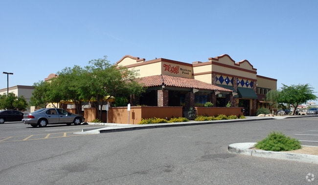
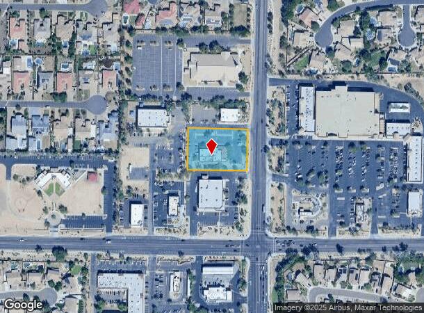
Property Record
21910 N 83Rd Ave, Peoria, AZ 85383

NEARBY LISTINGS FOR SALE OR LEASE
Property Detail
21910 N 83Rd Ave
Phoenix-Mesa-Chandler, AZ
Dv83 Subdivision
200-08-512
DV83 SUBDIVISION MCR 695-04
Restaurantbuilding
Maricopa
X
Arizona
04013C1265L
1
2025
1.25 AC
2025
Ctrl Peoria/Arrowhead
613800
Phoenix
7,145 SF
DEMOGRAPHICS near 21910 N 83Rd Ave
1 mile
3 mile
5 mile
2024 Total Population
10,459
94,555
214,462
2029 Population
11,207
102,412
232,062
Pop Growth 2024-2029
+ 7.15%
+ 8.31%
+ 8.21%
Average Age
39
43
44
2024 Total Households
3,387
35,777
82,484
HH Growth 2024-2029
+ 7.14%
+ 8.49%
+ 8.36%
Median Household Inc
$129,196
$99,975
$93,193
Avg Household Size
3.00
2.60
2.50
2024 Avg HH Vehicles
3.00
2.00
2.00
Median Home Value
$436,844
$417,519
$393,511
Median Year Built
1998
1996
1995
Nearby Places
Map Layers
Map Styles
 Street
 Aerial
Transit
 Traffic
 Biking
Places
Listings with unknown addresses are not visible on the map
- Restaurants
- Banks
- Shops
- Fitness
- Groceries
PUBLIC TRANSPORTATION
AIRPORT
Phoenix Sky Harbor International
Drive
Walk
Distance
Phoenix Sky Harbor International
43 min
30.8 mi
Nearby Properties
Address
Land Use
TOTAL SIZE
Lot Size
Zoning
Address
Land Use
TOTAL SIZE
Lot Size
Zoning
239,750 SF
85.34 AC
SR43
Address
Land Use
TOTAL SIZE
Lot Size
Zoning
248,777 SF
51.46 AC
AG
Address
Land Use
TOTAL SIZE
Lot Size
Zoning
4,500 SF
13.50 AC
PAD
Address
Land Use
TOTAL SIZE
Lot Size
Zoning
284,223 SF
10.02 AC
C-C
Address
Land Use
TOTAL SIZE
Lot Size
Zoning
708,928 SF
44.86 AC
Address
Land Use
TOTAL SIZE
Lot Size
Zoning
235,399 SF
41.79 AC
M-M
Address
Land Use
TOTAL SIZE
Lot Size
Zoning
399,561 SF
16.30 AC
Address
Land Use
TOTAL SIZE
Lot Size
Zoning
291,137 SF
38.49 AC
AG
Address
Land Use
TOTAL SIZE
Lot Size
Zoning
226,169 SF
20.48 AC
Address
Land Use
TOTAL SIZE
Lot Size
Zoning
133,377 SF
17.52 AC
PAD
Address
Land Use
TOTAL SIZE
Lot Size
Zoning
280,356 SF
12.73 AC
PAD
Address
Land Use
TOTAL SIZE
Lot Size
Zoning
440,494 SF
26.25 AC
PAD
Address
Land Use
TOTAL SIZE
Lot Size
Zoning
126,781 SF
10.06 AC
C-C
Address
Land Use
TOTAL SIZE
Lot Size
Zoning
375,604 SF
6.31 AC
M-M
Address
Land Use
TOTAL SIZE
Lot Size
Zoning
126,814 SF
31.56 AC
R17
Address
Land Use
TOTAL SIZE
Lot Size
Zoning
122,780 SF
18.75 AC
PAD
Address
Land Use
TOTAL SIZE
Lot Size
Zoning
112,300 SF
13.72 AC
PAD
Address
Land Use
TOTAL SIZE
Lot Size
Zoning
283,107 SF
14.60 AC
M-M
Address
Land Use
TOTAL SIZE
Lot Size
Zoning
96,045 SF
13.69 AC
PAD
Address
Land Use
TOTAL SIZE
Lot Size
Zoning
127,100 SF
3.57 AC
PAD
Address
Land Use
TOTAL SIZE
Lot Size
Zoning
96,016 SF
4.47 AC
PAD
Address
Land Use
TOTAL SIZE
Lot Size
Zoning
311,614 SF
19.03 AC
PAD
Address
Land Use
TOTAL SIZE
Lot Size
Zoning
187,392 SF
10.36 AC
PAD
Address
Land Use
TOTAL SIZE
Lot Size
Zoning
18.76 AC
M1
Address
Land Use
TOTAL SIZE
Lot Size
Zoning
156,940 SF
20.76 AC
PAD
Address
Land Use
TOTAL SIZE
Lot Size
Zoning
102,816 SF
35.12 AC
AG
Address
Land Use
TOTAL SIZE
Lot Size
Zoning
96,954 SF
13.47 AC
PAD
Address
Land Use
TOTAL SIZE
Lot Size
Zoning
127,616 SF
27.49 AC
PAD
Address
Land Use
TOTAL SIZE
Lot Size
Zoning
217,564 SF
22.91 AC
PAD
Address
Land Use
TOTAL SIZE
Lot Size
Zoning
139,095 SF
13.67 AC
PAD
The World's #1 Commercial Real Estate Marketplace
Connect with us
© 2026 CoStar Group
The information above has been obtained from sources believed reliable. While we do not doubt its accuracy we have not verified it and make no guarantee, warranty or representation about it. It is your responsibility to independently confirm its accuracy and completeness. Any projections, opinions, assumptions, or estimates used are for example only and do not represent the current or future performance of the property. The value of this transaction to you depends on tax and other factors which should be evaluated by your tax, financial, and legal advisors. You and your advisors should conduct a careful, independent investigation of the property to determine to your satisfaction the suitability of the property for your needs.