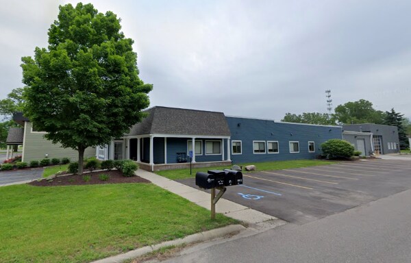
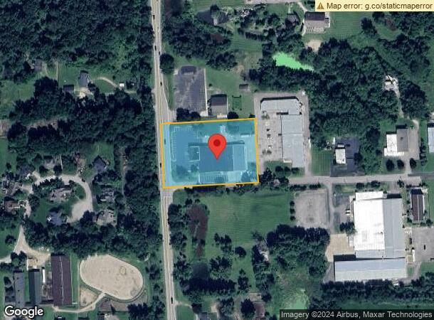
Property Record
2195 S Milford Rd, Milford, MI 48381


NEARBY LISTINGS FOR SALE OR LEASE
Property Detail
2195 S Milford Rd
16-22-300-026
T2N, R7E, SEC 22 PART OF SW 1/4 BEG AT PT DIST S 00-16-00 W 455.49 FT FROM W 1/4 COR, TH S 89-44-00 E 382.40 FT, TH S
Scientificpharmaceuticalmedicalresearchfacility
Oakland
X
Michigan
26125C0461F
2.28 AC
2024
Central I-96 Corridor
2025
Detroit
132100
Detroit-Warren-Dearborn, MI
24,466 SF
DEMOGRAPHICS near 2195 S Milford Rd
1 Mile
3 Mile
5 Mile
2024 Total Population
941
13,103
44,592
2029 Population
932
12,970
44,237
Pop Growth 2024-2029
(0.96%)
(1.02%)
(0.80%)
Average Age
45
43
42
2024 Total Households
338
5,211
16,945
HH Growth 2024-2029
(0.89%)
(1.06%)
(0.84%)
Median Household Inc
$120,432
$101,000
$107,497
Avg Household Size
2.70
2.50
2.60
2024 Avg HH Vehicles
2.00
2.00
2.00
Median Home Value
$463,698
$378,031
$357,404
Median Year Built
1988
1985
1990
Nearby Places
Map Layers
Map Styles
 Street
 Aerial
- Restaurants
- Banks
- Shops
- Fitness
- Groceries
PUBLIC TRANSPORTATION
AIRPORT
Detroit Metro Wayne County
DRIVE
WALK
Distance
Detroit Metro Wayne County
49 min
38.5 mi
Bishop International
DRIVE
WALK
Distance
Bishop International
58 min
42.9 mi
SALE & LEASE HISTORY
LISTING DATE
SALE/LEASE

Sep 25, 2016
For Lease
May 19, 2022
For Lease
Nearby Properties
Address
Land Use
TOTAL SIZE
Lot Size
Zoning
Address
Land Use
TOTAL SIZE
Lot Size
Zoning
1,569,676 SF
499.90 AC
II
Address
Land Use
TOTAL SIZE
Lot Size
Zoning
7,471 SF
114.63 AC
MM
Address
Land Use
TOTAL SIZE
Lot Size
Zoning
223,110 SF
18.53 AC
BI
Address
Land Use
TOTAL SIZE
Lot Size
Zoning
117,504 SF
12.57 AC
BI
Address
Land Use
TOTAL SIZE
Lot Size
Zoning
89,974 SF
Address
Land Use
TOTAL SIZE
Lot Size
Zoning
1,569,676 SF
Address
Land Use
TOTAL SIZE
Lot Size
Zoning
132,821 SF
13.48 AC
BI
Address
Land Use
TOTAL SIZE
Lot Size
Zoning
32,826 SF
22.12 AC
BI
Address
Land Use
TOTAL SIZE
Lot Size
Zoning
52,289 SF
11.37 AC
BI
Address
Land Use
TOTAL SIZE
Lot Size
Zoning
70,308 SF
2.43 AC
Address
Land Use
TOTAL SIZE
Lot Size
Zoning
30,659 SF
7.63 AC
Address
Land Use
TOTAL SIZE
Lot Size
Zoning
77,287 SF
1.62 AC
Address
Land Use
TOTAL SIZE
Lot Size
Zoning
70,463 SF
7.98 AC
AI
Address
Land Use
TOTAL SIZE
Lot Size
Zoning
53,882 SF
51.85 AC
UI
Address
Land Use
TOTAL SIZE
Lot Size
Zoning
55,844 SF
5.90 AC
AI
Address
Land Use
TOTAL SIZE
Lot Size
Zoning
72,727 SF
10.51 AC
Address
Land Use
TOTAL SIZE
Lot Size
Zoning
28,540 SF
3.72 AC
BI
Address
Land Use
TOTAL SIZE
Lot Size
Zoning
38,140 SF
10.63 AC
BI
Address
Land Use
TOTAL SIZE
Lot Size
Zoning
71,793 SF
5.06 AC
II
Address
Land Use
TOTAL SIZE
Lot Size
Zoning
42,842 SF
3.20 AC
KV
Address
Land Use
TOTAL SIZE
Lot Size
Zoning
40 AC
MM
Address
Land Use
TOTAL SIZE
Lot Size
Zoning
40,464 SF
16.35 AC
BI
Address
Land Use
TOTAL SIZE
Lot Size
Zoning
41,240 SF
7.56 AC
BI
Address
Land Use
TOTAL SIZE
Lot Size
Zoning
19,596 SF
3.78 AC
Address
Land Use
TOTAL SIZE
Lot Size
Zoning
25,092 SF
3.09 AC
BI
Address
Land Use
TOTAL SIZE
Lot Size
Zoning
22,609 SF
5.06 AC
BI
Address
Land Use
TOTAL SIZE
Lot Size
Zoning
14,689 SF
2.05 AC
BI
Address
Land Use
TOTAL SIZE
Lot Size
Zoning
23,440 SF
24.92 AC
The World's #1 Commercial Real Estate Marketplace
Connect with us
© 2026 CoStar Group
The information above has been obtained from sources believed reliable. While we do not doubt its accuracy we have not verified it and make no guarantee, warranty or representation about it. It is your responsibility to independently confirm its accuracy and completeness. Any projections, opinions, assumptions, or estimates used are for example only and do not represent the current or future performance of the property. The value of this transaction to you depends on tax and other factors which should be evaluated by your tax, financial, and legal advisors. You and your advisors should conduct a careful, independent investigation of the property to determine to your satisfaction the suitability of the property for your needs.