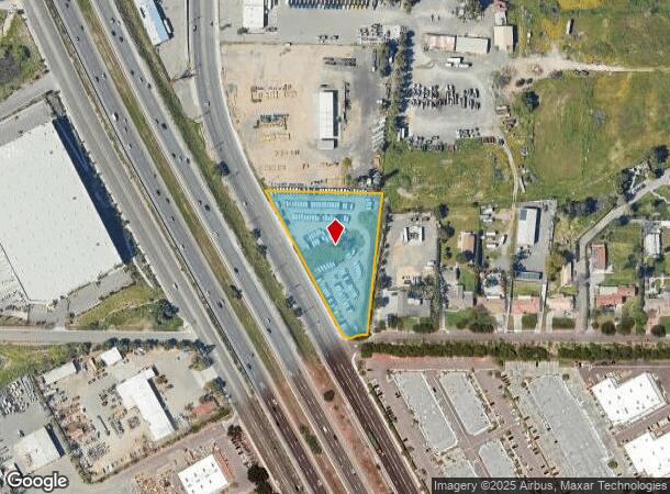
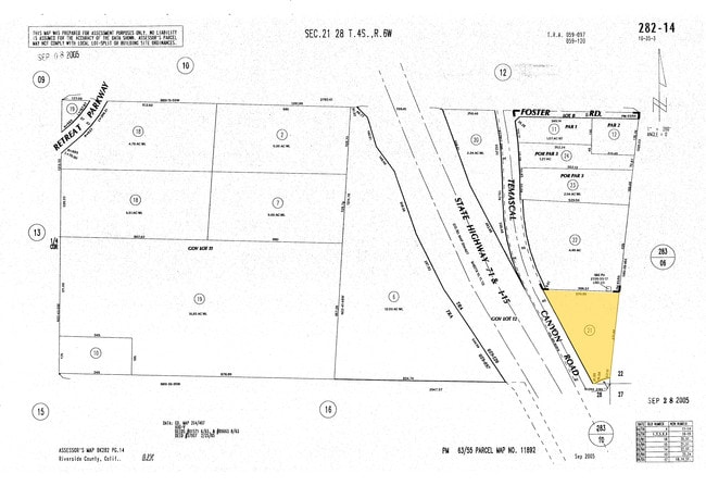
Property Record
21950 Temescal Canyon Rd, Corona, CA 92883
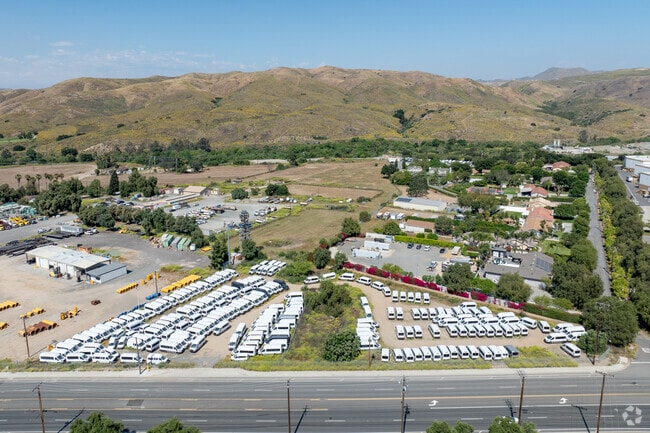
This Property Is For Sale
NEARBY LISTINGS FOR SALE OR LEASE
Property Detail
21950 Temescal Canyon Rd
282-140-030
ACRES 2.32999992 ACREAGEQUALCODE ML
Commercialacreage
Riverside
X
California
06059C0225J
2.33 AC
2024
Corona/Eastvale
2025
Inland Empire (California)
041910
Riverside-San Bernardino-Ontario, CA
DEMOGRAPHICS near 21950 Temescal Canyon Rd
1 Mile
3 Mile
5 Mile
2024 Total Population
5,553
26,498
63,059
2029 Population
5,880
27,971
66,322
Pop Growth 2024-2029
+ 5.89%
+ 5.56%
+ 5.17%
Average Age
37
39
39
2024 Total Households
1,810
8,405
18,992
HH Growth 2024-2029
+ 5.52%
+ 5.02%
+ 4.68%
Median Household Inc
$120,887
$121,066
$122,489
Avg Household Size
3.00
3.10
3.20
2024 Avg HH Vehicles
2.00
2.00
2.00
Median Home Value
$674,666
$689,699
$706,605
Median Year Built
2001
2001
1999
Nearby Places
Map Layers
Map Styles
 Street
 Aerial
- Restaurants
- Banks
- Shops
- Fitness
- Groceries
PUBLIC TRANSPORTATION
COMMUTER RAIL
North Main Corona (91 Line - Southern California Regional Rail Authority (Metrolink), Inland Empire-Orange County Line - Southern California Regional Rail Authority (Metrolink))
DRIVE
WALK
Distance
North Main Corona (91 Line - Southern California Regional Rail Authority (Metrolink), Inland Empire-Orange County Line - Southern California Regional Rail Authority (Metrolink))
12 min
8.1 mi
AIRPORT
Ontario International
DRIVE
WALK
Distance
Ontario International
29 min
22.2 mi
John Wayne/Orange County
DRIVE
WALK
Distance
John Wayne/Orange County
45 min
35.8 mi
Freight Ports
Port of Long Beach
DRIVE
WALK
Distance
Port of Long Beach
66 min
49.8 mi
Nearby Properties
Address
Land Use
TOTAL SIZE
Lot Size
Zoning
Address
Land Use
TOTAL SIZE
Lot Size
Zoning
18.76 AC
Address
Land Use
TOTAL SIZE
Lot Size
Zoning
39,646 SF
13.13 AC
Address
Land Use
TOTAL SIZE
Lot Size
Zoning
248,799 SF
12.06 AC
Address
Land Use
TOTAL SIZE
Lot Size
Zoning
151,672 SF
0.69 AC
Address
Land Use
TOTAL SIZE
Lot Size
Zoning
159,921 SF
5.29 AC
EC
Address
Land Use
TOTAL SIZE
Lot Size
Zoning
96,943 SF
12.76 AC
SP
Address
Land Use
TOTAL SIZE
Lot Size
Zoning
164,888 SF
9.88 AC
Address
Land Use
TOTAL SIZE
Lot Size
Zoning
246,225 SF
26.09 AC
Address
Land Use
TOTAL SIZE
Lot Size
Zoning
139,800 SF
9.21 AC
IP
Address
Land Use
TOTAL SIZE
Lot Size
Zoning
153,541 SF
0.99 AC
Address
Land Use
TOTAL SIZE
Lot Size
Zoning
51.33 AC
Address
Land Use
TOTAL SIZE
Lot Size
Zoning
66,031 SF
3.78 AC
Address
Land Use
TOTAL SIZE
Lot Size
Zoning
83,926 SF
10.03 AC
Address
Land Use
TOTAL SIZE
Lot Size
Zoning
64,224 SF
10.70 AC
Address
Land Use
TOTAL SIZE
Lot Size
Zoning
53,894 SF
4.76 AC
Address
Land Use
TOTAL SIZE
Lot Size
Zoning
5.23 AC
Address
Land Use
TOTAL SIZE
Lot Size
Zoning
89,682 SF
4.65 AC
Address
Land Use
TOTAL SIZE
Lot Size
Zoning
90,765 SF
7.69 AC
Address
Land Use
TOTAL SIZE
Lot Size
Zoning
64,247 SF
2.88 AC
Address
Land Use
TOTAL SIZE
Lot Size
Zoning
600 SF
29.53 AC
MRA
Address
Land Use
TOTAL SIZE
Lot Size
Zoning
128,163 SF
10.01 AC
Address
Land Use
TOTAL SIZE
Lot Size
Zoning
78,327 SF
5.47 AC
Address
Land Use
TOTAL SIZE
Lot Size
Zoning
74,349 SF
12.83 AC
Address
Land Use
TOTAL SIZE
Lot Size
Zoning
35.63 AC
MRA
Address
Land Use
TOTAL SIZE
Lot Size
Zoning
88,300 SF
6.50 AC
Address
Land Use
TOTAL SIZE
Lot Size
Zoning
49,500 SF
0.42 AC
Address
Land Use
TOTAL SIZE
Lot Size
Zoning
65,140 SF
4.13 AC
The World's #1 Commercial Real Estate Marketplace
Connect with us
© 2025 CoStar Group
The information above has been obtained from sources believed reliable. While we do not doubt its accuracy we have not verified it and make no guarantee, warranty or representation about it. It is your responsibility to independently confirm its accuracy and completeness. Any projections, opinions, assumptions, or estimates used are for example only and do not represent the current or future performance of the property. The value of this transaction to you depends on tax and other factors which should be evaluated by your tax, financial, and legal advisors. You and your advisors should conduct a careful, independent investigation of the property to determine to your satisfaction the suitability of the property for your needs.