Property Record
2196 Nc Highway 42 Pkwy W, Clayton, NC 27520
NEARBY LISTINGS FOR SALE OR LEASE
Property Detail
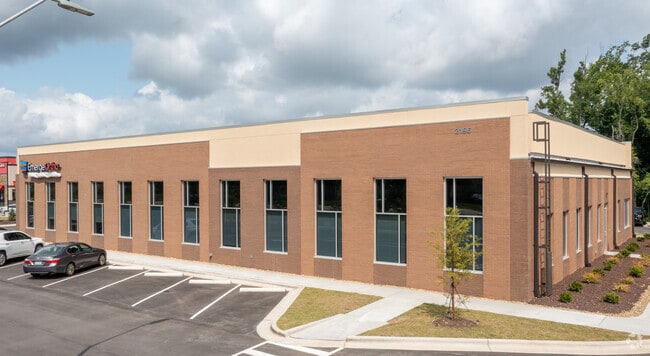
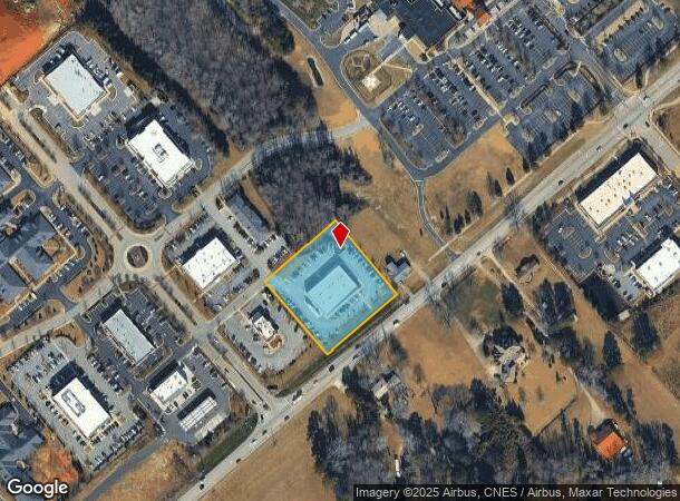
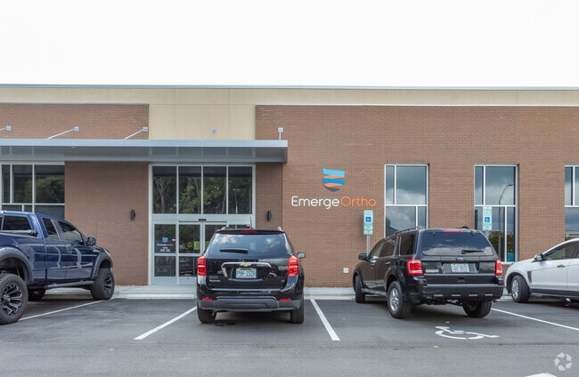
2196 Nc Highway 42 Pkwy W
Raleigh, NC
Spring Branch Medical And Commercial Par
05F02035G
LOT 2 SPRING BRANCH MED & COMM PARK 89/313
Medicalbuilding
Johnston
X
North Carolina
3720164800K
2
2025
1.65 AC
2025
Johnston County
052814
Raleigh/Durham
11,000 SF
DEMOGRAPHICS near 2196 Nc Highway 42 Pkwy W
1 Mile
3 Mile
5 Mile
2024 Total Population
1,960
28,108
63,920
2029 Population
2,366
34,065
77,055
Pop Growth 2024-2029
+ 20.71%
+ 21.19%
+ 20.55%
Average Age
40
39
38
2024 Total Households
723
10,701
23,844
HH Growth 2024-2029
+ 20.75%
+ 21.38%
+ 20.74%
Median Household Inc
$89,304
$70,415
$77,193
Avg Household Size
2.60
2.60
2.60
2024 Avg HH Vehicles
2.00
2.00
2.00
Median Home Value
$227,305
$248,815
$271,223
Median Year Built
2004
1999
2001
Nearby Places
Map Layers
Map Styles
 Street
 Aerial
- Restaurants
- Banks
- Shops
- Fitness
- Groceries
PUBLIC TRANSPORTATION
AIRPORT
Raleigh-Durham International
DRIVE
WALK
Distance
Raleigh-Durham International
40 min
31.3 mi
Freight Ports
Port of Wilmington
DRIVE
WALK
Distance
Port of Wilmington
142 min
122.0 mi
SALE & LEASE HISTORY
LISTING DATE
SALE/LEASE

Aug 01, 2017
For Lease
Nearby Properties
Address
Land Use
TOTAL SIZE
Lot Size
Zoning
Address
Land Use
TOTAL SIZE
Lot Size
Zoning
76,128 SF
34.03 AC
OFF
Address
Land Use
TOTAL SIZE
Lot Size
Zoning
5,616 SF
22.46 AC
PUD
Address
Land Use
TOTAL SIZE
Lot Size
Zoning
691,230 SF
106.53 AC
IND
Address
Land Use
TOTAL SIZE
Lot Size
Zoning
5,038 SF
15.45 AC
COM
Address
Land Use
TOTAL SIZE
Lot Size
Zoning
65,586 SF
15.48 AC
OFF
Address
Land Use
TOTAL SIZE
Lot Size
Zoning
298,354 SF
36.16 AC
IND
Address
Land Use
TOTAL SIZE
Lot Size
Zoning
118,430 SF
24.82 AC
IND
Address
Land Use
TOTAL SIZE
Lot Size
Zoning
24,552 SF
17.40 AC
RES
Address
Land Use
TOTAL SIZE
Lot Size
Zoning
85,447 SF
36.25 AC
RES
Address
Land Use
TOTAL SIZE
Lot Size
Zoning
10,052 SF
11.33 AC
OFF
Address
Land Use
TOTAL SIZE
Lot Size
Zoning
201,003 SF
21.64 AC
SUP
Address
Land Use
TOTAL SIZE
Lot Size
Zoning
2,664 SF
448.85 AC
COM
Address
Land Use
TOTAL SIZE
Lot Size
Zoning
25,000 SF
14.37 AC
COM
Address
Land Use
TOTAL SIZE
Lot Size
Zoning
93,012 SF
3.11 AC
SUP
Address
Land Use
TOTAL SIZE
Lot Size
Zoning
67,730 SF
20.40 AC
RES
Address
Land Use
TOTAL SIZE
Lot Size
Zoning
68,067 SF
7.50 AC
COM
Address
Land Use
TOTAL SIZE
Lot Size
Zoning
13,308 SF
41.37 AC
OFF
Address
Land Use
TOTAL SIZE
Lot Size
Zoning
74,219 SF
15.88 AC
COM
Address
Land Use
TOTAL SIZE
Lot Size
Zoning
24,552 SF
8.05 AC
RES
Address
Land Use
TOTAL SIZE
Lot Size
Zoning
41,446 SF
7.92 AC
COM
Address
Land Use
TOTAL SIZE
Lot Size
Zoning
42,348 SF
9.10 AC
SUP
Address
Land Use
TOTAL SIZE
Lot Size
Zoning
1,100 SF
9.63 AC
SUP
Address
Land Use
TOTAL SIZE
Lot Size
Zoning
29,588 SF
2.39 AC
COM
Address
Land Use
TOTAL SIZE
Lot Size
Zoning
63,660 SF
6.44 AC
SUP
Address
Land Use
TOTAL SIZE
Lot Size
Zoning
27,780 SF
11.68 AC
COM
Address
Land Use
TOTAL SIZE
Lot Size
Zoning
27,048 SF
2.41 AC
COM
Address
Land Use
TOTAL SIZE
Lot Size
Zoning
5,275 SF
6.36 AC
SUP
Address
Land Use
TOTAL SIZE
Lot Size
Zoning
36,971 SF
3.08 AC
RES
Address
Land Use
TOTAL SIZE
Lot Size
Zoning
5,381 SF
1.18 AC
COM
Address
Land Use
TOTAL SIZE
Lot Size
Zoning
27,720 SF
2.42 AC
COM
The World's #1 Commercial Real Estate Marketplace
Connect with us
© 2026 CoStar Group
The information above has been obtained from sources believed reliable. While we do not doubt its accuracy we have not verified it and make no guarantee, warranty or representation about it. It is your responsibility to independently confirm its accuracy and completeness. Any projections, opinions, assumptions, or estimates used are for example only and do not represent the current or future performance of the property. The value of this transaction to you depends on tax and other factors which should be evaluated by your tax, financial, and legal advisors. You and your advisors should conduct a careful, independent investigation of the property to determine to your satisfaction the suitability of the property for your needs.