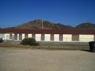
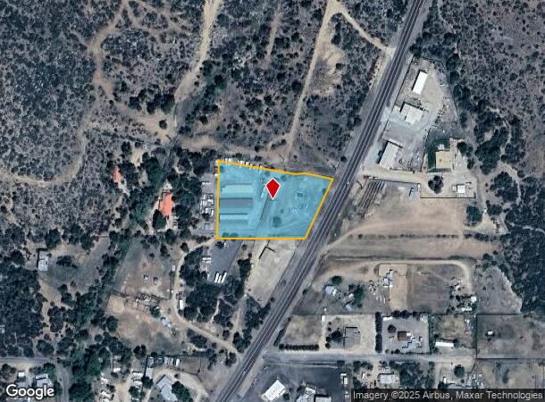
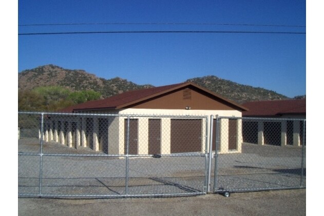
Property Record
21972 S State Route 89, Yarnell, AZ 85362
NEARBY LISTINGS FOR SALE OR LEASE
-
-
View all Yarnell listings for sale on LoopNet.com
Property Detail
21972 S State Route 89
203-01-004H
AN IRREG PCL LYNG IN THE SE4 OF SEC 2 WITH THE SW COR LYNG APPROX 1330 W FROM THE SE COR OF SEC 2-10-5W CONT 2.12AC PER 3553/908
Shipyard
Yavapai
X
Arizona
04025C3105H
2.12 AC
2024
Prescott & Sedona
2026
Other Market Areas
001403
Prescott, AZ
9,760 SF
DEMOGRAPHICS near 21972 S State Route 89
1 Mile
3 Mile
5 Mile
2024 Total Population
63
191
1,029
2029 Population
68
207
1,128
Pop Growth 2024-2029
+ 7.94%
+ 8.38%
+ 9.62%
Average Age
56
56
58
2024 Total Households
33
99
550
HH Growth 2024-2029
+ 9.09%
+ 9.09%
+ 10.18%
Median Household Inc
$42,500
$41,818
$43,810
Avg Household Size
1.70
1.90
1.90
2024 Avg HH Vehicles
2.00
2.00
2.00
Median Home Value
$237,500
$226,190
$244,838
Median Year Built
1985
1985
1984
Nearby Places
Map Layers
Map Styles
 Street
 Aerial
- Restaurants
- Banks
- Shops
- Fitness
- Groceries
Nearby Properties
Address
Land Use
TOTAL SIZE
Lot Size
Zoning
Address
Land Use
TOTAL SIZE
Lot Size
Zoning
19,363 SF
19.98 AC
Address
Land Use
TOTAL SIZE
Lot Size
Zoning
7,446 SF
208.10 AC
Address
Land Use
TOTAL SIZE
Lot Size
Zoning
9,033 SF
1.85 AC
Address
Land Use
TOTAL SIZE
Lot Size
Zoning
8,575 SF
28.99 AC
Address
Land Use
TOTAL SIZE
Lot Size
Zoning
4,649 SF
56.81 AC
Address
Land Use
TOTAL SIZE
Lot Size
Zoning
6,886 SF
0.69 AC
Address
Land Use
TOTAL SIZE
Lot Size
Zoning
4,867 SF
6 AC
Address
Land Use
TOTAL SIZE
Lot Size
Zoning
4,450 SF
0.68 AC
Address
Land Use
TOTAL SIZE
Lot Size
Zoning
6,383 SF
1.27 AC
Address
Land Use
TOTAL SIZE
Lot Size
Zoning
3,840 SF
1.10 AC
Address
Land Use
TOTAL SIZE
Lot Size
Zoning
3,587 SF
20 AC
Address
Land Use
TOTAL SIZE
Lot Size
Zoning
4,670 SF
2.87 AC
Address
Land Use
TOTAL SIZE
Lot Size
Zoning
3,132 SF
1.30 AC
Address
Land Use
TOTAL SIZE
Lot Size
Zoning
2,875 SF
0.23 AC
Address
Land Use
TOTAL SIZE
Lot Size
Zoning
2,015 SF
0.41 AC
Address
Land Use
TOTAL SIZE
Lot Size
Zoning
3,465 SF
0.64 AC
Address
Land Use
TOTAL SIZE
Lot Size
Zoning
4,760 SF
0.81 AC
Address
Land Use
TOTAL SIZE
Lot Size
Zoning
147.55 AC
Address
Land Use
TOTAL SIZE
Lot Size
Zoning
Address
Land Use
TOTAL SIZE
Lot Size
Zoning
4,429 SF
0.83 AC
Address
Land Use
TOTAL SIZE
Lot Size
Zoning
5,718 SF
1.16 AC
Address
Land Use
TOTAL SIZE
Lot Size
Zoning
3,996 SF
1.06 AC
Address
Land Use
TOTAL SIZE
Lot Size
Zoning
3,526 SF
0.26 AC
Address
Land Use
TOTAL SIZE
Lot Size
Zoning
4,600 SF
1.72 AC
Address
Land Use
TOTAL SIZE
Lot Size
Zoning
Address
Land Use
TOTAL SIZE
Lot Size
Zoning
2,261 SF
0.35 AC
Address
Land Use
TOTAL SIZE
Lot Size
Zoning
1,432 SF
0.34 AC
Address
Land Use
TOTAL SIZE
Lot Size
Zoning
3,462 SF
0.07 AC
Address
Land Use
TOTAL SIZE
Lot Size
Zoning
1,538 SF
0.63 AC
The World's #1 Commercial Real Estate Marketplace
Connect with us
© 2025 CoStar Group
The information above has been obtained from sources believed reliable. While we do not doubt its accuracy we have not verified it and make no guarantee, warranty or representation about it. It is your responsibility to independently confirm its accuracy and completeness. Any projections, opinions, assumptions, or estimates used are for example only and do not represent the current or future performance of the property. The value of this transaction to you depends on tax and other factors which should be evaluated by your tax, financial, and legal advisors. You and your advisors should conduct a careful, independent investigation of the property to determine to your satisfaction the suitability of the property for your needs.