Property Record
21979 Carter Rd, Estero, FL 33928

Save to a Folder
{{folder.Name}}
{{folder.ListingIds.length}} Properties
{{folder.ListingIds.length}} Property
Create a New Folder
This Property Is For Sale
Property Detail
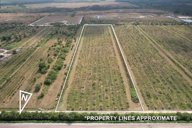
21979 Carter Rd
33-46-27-L4-00001.30A0
E 335 OF THE W 1311.81 OF SW 1/4 OF SW 1/4 AND W 1/2 OF SE 1/4 OF SW 1/4
Orchard
LEE
AG-2
Florida
B and X Area of moderate flood hazard, usually the area between the limits of the 100-year and 500-year floods.
19.12 AC
2025
Estero
2025
Southwest Florida
050210
Cape Coral-Fort Myers, FL
NEARBY LISTINGS FOR SALE OR LEASE
-
-
View all Estero listings for sale on LoopNet.com
DEMOGRAPHICS near 21979 Carter Rd
1 mile
3 mile
5 mile
2025 Total Population
46
3,074
5,549
2030 Population
53
3,555
6,370
Pop Growth 2025-2030
+ 15.22%
+ 15.65%
+ 14.80%
Average Age
43
45
43
2025 Total Households
18
1,223
2,101
HH Growth 2025-2030
+ 11.11%
+ 15.13%
+ 14.42%
Median Household Inc
$124,999
$93,948
$128,255
Avg Household Size
2.40
2.40
2.60
2025 Avg HH Vehicles
2.00
2.00
2.00
Median Home Value
$687,500
$651,151
$718,472
Median Year Built
2011
2010
2011
Nearby Places
Map Layers
Map Styles
 Street
 Aerial
Layers
 Traffic
 Biking
Places
Listings with unknown addresses are not visible on the map
- Restaurants
- Banks
- Shops
- Fitness
- Groceries
PUBLIC TRANSPORTATION
AIRPORT
Southwest Florida International
Drive
Walk
Distance
Southwest Florida International
40 min
22.8 mi
Freight Ports
Port Everglades
Drive
Walk
Distance
Port Everglades
150 min
120.0 mi
Nearby Properties
Address
Land Use
TOTAL SIZE
Lot Size
Zoning
Address
Land Use
TOTAL SIZE
Lot Size
Zoning
13.45 AC
MPD
Address
Land Use
TOTAL SIZE
Lot Size
Zoning
18,224 SF
5 AC
RPD
Address
Land Use
TOTAL SIZE
Lot Size
Zoning
631.99 AC
AG-2
Address
Land Use
TOTAL SIZE
Lot Size
Zoning
49,419 SF
607.60 AC
AG-2
Address
Land Use
TOTAL SIZE
Lot Size
Zoning
178.95 AC
IPD
Address
Land Use
TOTAL SIZE
Lot Size
Zoning
30,536 SF
198.96 AC
AG-2
Address
Land Use
TOTAL SIZE
Lot Size
Zoning
24,258 SF
645.82 AC
AG-2
Address
Land Use
TOTAL SIZE
Lot Size
Zoning
325.39 AC
AG-2
Address
Land Use
TOTAL SIZE
Lot Size
Zoning
252.80 AC
AG-2
Address
Land Use
TOTAL SIZE
Lot Size
Zoning
240 AC
AG-2
Address
Land Use
TOTAL SIZE
Lot Size
Zoning
3,200 SF
630.75 AC
A
Address
Land Use
TOTAL SIZE
Lot Size
Zoning
4,336 SF
10.14 AC
AG-2
Address
Land Use
TOTAL SIZE
Lot Size
Zoning
79.68 AC
IPD
Address
Land Use
TOTAL SIZE
Lot Size
Zoning
3,954 SF
54.28 AC
IPD
Address
Land Use
TOTAL SIZE
Lot Size
Zoning
7,233 SF
9.22 AC
AG-2
Address
Land Use
TOTAL SIZE
Lot Size
Zoning
4,670 SF
10.63 AC
AG-2
Address
Land Use
TOTAL SIZE
Lot Size
Zoning
4.74 AC
AG-2
Address
Land Use
TOTAL SIZE
Lot Size
Zoning
5,305 SF
10.78 AC
AG-2
Address
Land Use
TOTAL SIZE
Lot Size
Zoning
559.34 AC
MPD
Address
Land Use
TOTAL SIZE
Lot Size
Zoning
8,083 SF
9.98 AC
AG-2
Address
Land Use
TOTAL SIZE
Lot Size
Zoning
13,224 SF
10 AC
AG-2
Address
Land Use
TOTAL SIZE
Lot Size
Zoning
4,548 SF
10.34 AC
AG-2
Address
Land Use
TOTAL SIZE
Lot Size
Zoning
6,960 SF
19.43 AC
AG-2
Address
Land Use
TOTAL SIZE
Lot Size
Zoning
4,910 SF
10.24 AC
AG-2
Address
Land Use
TOTAL SIZE
Lot Size
Zoning
3,050 SF
63.55 AC
AG-2
Address
Land Use
TOTAL SIZE
Lot Size
Zoning
1,060 SF
9.93 AC
AG-2
Address
Land Use
TOTAL SIZE
Lot Size
Zoning
5,192 SF
9.46 AC
AG-2
Address
Land Use
TOTAL SIZE
Lot Size
Zoning
10.81 AC
AG-2
Address
Land Use
TOTAL SIZE
Lot Size
Zoning
10.14 AC
AG-2
Address
Land Use
TOTAL SIZE
Lot Size
Zoning
10.08 AC
AG-2
The World's #1 Commercial Real Estate Marketplace
Connect with us
© 2026 CoStar Group
The information above has been obtained from sources believed reliable. While we do not doubt its accuracy we have not verified it and make no guarantee, warranty or representation about it. It is your responsibility to independently confirm its accuracy and completeness. Any projections, opinions, assumptions, or estimates used are for example only and do not represent the current or future performance of the property. The value of this transaction to you depends on tax and other factors which should be evaluated by your tax, financial, and legal advisors. You and your advisors should conduct a careful, independent investigation of the property to determine to your satisfaction the suitability of the property for your needs.