Property Record
22 Bartlett Rd, Gorham, ME 04038
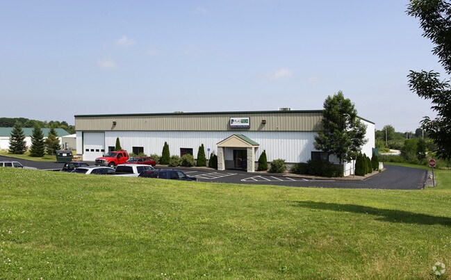

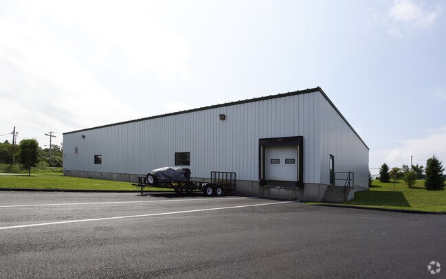
Property Detail
22 Bartlett Rd
GRHM-000012-000026-000002
Cumberland
Industrialgeneral
Maine
1
2
B and X Area of moderate flood hazard, usually the area between the limits of the 100-year and 500-year floods.
2.22 AC
2025
SW Cumberland County
2025
Portland/South Portland
004001
Portland-South Portland, ME
11,600 SF
NEARBY LISTINGS FOR SALE OR LEASE
DEMOGRAPHICS near 22 Bartlett Rd
1 mile
3 mile
5 mile
2024 Total Population
2,968
24,699
59,449
2029 Population
3,060
25,532
61,315
Pop Growth 2024-2029
+ 3.10%
+ 3.37%
+ 3.14%
Average Age
41
41
41
2024 Total Households
1,299
10,289
24,374
HH Growth 2024-2029
+ 3.23%
+ 3.48%
+ 3.27%
Median Household Inc
$81,234
$75,012
$75,371
Avg Household Size
2.30
2.30
2.30
2024 Avg HH Vehicles
2.00
2.00
2.00
Median Home Value
$295,056
$324,376
$350,403
Median Year Built
1957
1972
1971
Nearby Places
Map Layers
Map Styles
 Street
 Aerial
Transit
 Traffic
 Biking
Places
Listings with unknown addresses are not visible on the map
- Restaurants
- Banks
- Shops
- Fitness
- Groceries
PUBLIC TRANSPORTATION
COMMUTER RAIL
Portland (Downeaster - Amtrak)
Drive
Walk
Distance
Portland (Downeaster - Amtrak)
14 min
6.5 mi
AIRPORT
Portland International Jetport
Drive
Walk
Distance
Portland International Jetport
15 min
5.9 mi
Freight Ports
Portland, ME
Drive
Walk
Distance
Portland, ME
17 min
9.2 mi
Nearby Properties
Address
Land Use
TOTAL SIZE
Lot Size
Zoning
Address
Land Use
TOTAL SIZE
Lot Size
Zoning
84,636 SF
31.70 AC
22
Address
Land Use
TOTAL SIZE
Lot Size
Zoning
10.08 AC
Address
Land Use
TOTAL SIZE
Lot Size
Zoning
53.27 AC
22
Address
Land Use
TOTAL SIZE
Lot Size
Zoning
13.20 AC
I
Address
Land Use
TOTAL SIZE
Lot Size
Zoning
55.70 AC
14
Address
Land Use
TOTAL SIZE
Lot Size
Zoning
139,588 SF
0.85 AC
16
Address
Land Use
TOTAL SIZE
Lot Size
Zoning
17.95 AC
11
Address
Land Use
TOTAL SIZE
Lot Size
Zoning
152,378 SF
29.34 AC
21
Address
Land Use
TOTAL SIZE
Lot Size
Zoning
90,848 SF
15.75 AC
11
Address
Land Use
TOTAL SIZE
Lot Size
Zoning
93,041 SF
5.53 AC
UR
Address
Land Use
TOTAL SIZE
Lot Size
Zoning
83,509 SF
7.34 AC
17
Address
Land Use
TOTAL SIZE
Lot Size
Zoning
121,996 SF
24.53 AC
17
Address
Land Use
TOTAL SIZE
Lot Size
Zoning
7.06 AC
17
Address
Land Use
TOTAL SIZE
Lot Size
Zoning
87,850 SF
23 AC
19
Address
Land Use
TOTAL SIZE
Lot Size
Zoning
12.15 AC
11
Address
Land Use
TOTAL SIZE
Lot Size
Zoning
148,964 SF
35.12 AC
UR
Address
Land Use
TOTAL SIZE
Lot Size
Zoning
Address
Land Use
TOTAL SIZE
Lot Size
Zoning
2,014 SF
189.60 AC
DZ
Address
Land Use
TOTAL SIZE
Lot Size
Zoning
20.32 AC
DZ
Address
Land Use
TOTAL SIZE
Lot Size
Zoning
69,740 SF
3.26 AC
Address
Land Use
TOTAL SIZE
Lot Size
Zoning
7,860 SF
3.07 AC
UC
Address
Land Use
TOTAL SIZE
Lot Size
Zoning
79.65 AC
UR
Address
Land Use
TOTAL SIZE
Lot Size
Zoning
3.44 AC
27
Address
Land Use
TOTAL SIZE
Lot Size
Zoning
83,135 SF
7.23 AC
11
Address
Land Use
TOTAL SIZE
Lot Size
Zoning
25.14 AC
I
Address
Land Use
TOTAL SIZE
Lot Size
Zoning
157,320 SF
15 AC
Address
Land Use
TOTAL SIZE
Lot Size
Zoning
60,869 SF
17.96 AC
UR
Address
Land Use
TOTAL SIZE
Lot Size
Zoning
56,487 SF
2.93 AC
Address
Land Use
TOTAL SIZE
Lot Size
Zoning
97,200 SF
12.50 AC
12
Address
Land Use
TOTAL SIZE
Lot Size
Zoning
45,408 SF
12.15 AC
11
The World's #1 Commercial Real Estate Marketplace
Connect with us
© 2026 CoStar Group
The information above has been obtained from sources believed reliable. While we do not doubt its accuracy we have not verified it and make no guarantee, warranty or representation about it. It is your responsibility to independently confirm its accuracy and completeness. Any projections, opinions, assumptions, or estimates used are for example only and do not represent the current or future performance of the property. The value of this transaction to you depends on tax and other factors which should be evaluated by your tax, financial, and legal advisors. You and your advisors should conduct a careful, independent investigation of the property to determine to your satisfaction the suitability of the property for your needs.