Property Record
22 Chestnut St, Brattleboro, VT 05301


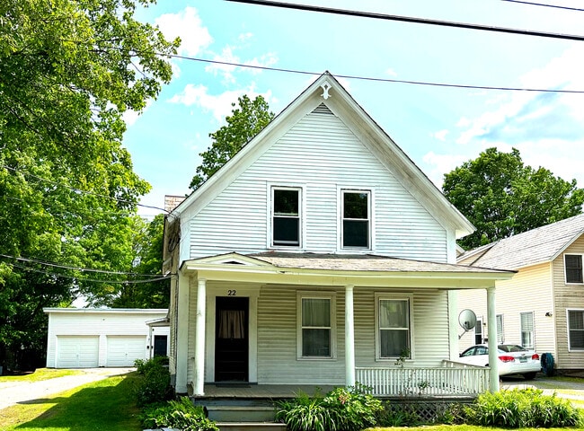
This Property Is For Sale
NEARBY LISTINGS FOR SALE OR LEASE
Property Detail
22 Chestnut St
Other Market Areas
Windham
081-025-18040
Vermont
Condominium
Vermont South Area
DEMOGRAPHICS near 22 Chestnut St
1 Mile
3 Mile
5 Mile
2024 Total Population
7,322
12,543
17,059
2029 Population
7,373
12,597
17,175
Pop Growth 2024-2029
+ 0.70%
+ 0.43%
+ 0.68%
Average Age
44
45
45
2024 Total Households
3,655
6,036
7,962
HH Growth 2024-2029
+ 0.98%
+ 0.55%
+ 0.67%
Median Household Inc
$41,136
$48,605
$55,769
Avg Household Size
1.90
2.00
2.00
2024 Avg HH Vehicles
1.00
1.00
2.00
Median Home Value
$219,621
$225,524
$229,051
Median Year Built
1952
1971
1973
Nearby Places
Map Layers
Map Styles
 Street
 Aerial
- Restaurants
- Banks
- Shops
- Fitness
- Groceries
PUBLIC TRANSPORTATION
COMMUTER RAIL
Brattleboro Amtrak Station (Vermonter - Amtrak)
DRIVE
WALK
Distance
Brattleboro Amtrak Station (Vermonter - Amtrak)
3 min
18 min
1.0 mi
Freight Ports
Albany, NY Port
DRIVE
WALK
Distance
Albany, NY Port
132 min
81.2 mi
Nearby Properties
Address
Land Use
TOTAL SIZE
Lot Size
Zoning
Address
Land Use
TOTAL SIZE
Lot Size
Zoning
211,712 SF
45.69 AC
IP / I
Address
Land Use
TOTAL SIZE
Lot Size
Zoning
Address
Land Use
TOTAL SIZE
Lot Size
Zoning
160,772 SF
20.62 AC
RC
Address
Land Use
TOTAL SIZE
Lot Size
Zoning
53,655 SF
11.95 AC
IP
Address
Land Use
TOTAL SIZE
Lot Size
Zoning
Address
Land Use
TOTAL SIZE
Lot Size
Zoning
Address
Land Use
TOTAL SIZE
Lot Size
Zoning
61,056 SF
9.94 AC
PU
Address
Land Use
TOTAL SIZE
Lot Size
Zoning
25.40 AC
Address
Land Use
TOTAL SIZE
Lot Size
Zoning
25,246 SF
1.11 AC
Address
Land Use
TOTAL SIZE
Lot Size
Zoning
15.56 AC
C / CO
Address
Land Use
TOTAL SIZE
Lot Size
Zoning
14,325 SF
IP / I
Address
Land Use
TOTAL SIZE
Lot Size
Zoning
21,865 SF
0.96 AC
Address
Land Use
TOTAL SIZE
Lot Size
Zoning
11.64 AC
CI / I
Address
Land Use
TOTAL SIZE
Lot Size
Zoning
135,935 SF
26.51 AC
N5 / N
Address
Land Use
TOTAL SIZE
Lot Size
Zoning
9.94 AC
C / CO
Address
Land Use
TOTAL SIZE
Lot Size
Zoning
11.44 AC
C / CO
Address
Land Use
TOTAL SIZE
Lot Size
Zoning
28 AC
CI
Address
Land Use
TOTAL SIZE
Lot Size
Zoning
Address
Land Use
TOTAL SIZE
Lot Size
Zoning
11,388 SF
0.79 AC
UC
Address
Land Use
TOTAL SIZE
Lot Size
Zoning
5 AC
C / CO
Address
Land Use
TOTAL SIZE
Lot Size
Zoning
12,376 SF
1.51 AC
UC
Address
Land Use
TOTAL SIZE
Lot Size
Zoning
43.10 AC
RR / R
Address
Land Use
TOTAL SIZE
Lot Size
Zoning
33,579 SF
4 AC
UC
Address
Land Use
TOTAL SIZE
Lot Size
Zoning
12.89 AC
NR
Address
Land Use
TOTAL SIZE
Lot Size
Zoning
1,276 SF
32.94 AC
RR
Address
Land Use
TOTAL SIZE
Lot Size
Zoning
0.87 AC
UC
Address
Land Use
TOTAL SIZE
Lot Size
Zoning
Address
Land Use
TOTAL SIZE
Lot Size
Zoning
15,471 SF
4.75 AC
C / CO
Address
Land Use
TOTAL SIZE
Lot Size
Zoning
3.93 AC
C
Address
Land Use
TOTAL SIZE
Lot Size
Zoning
7,304 SF
3.40 AC
COMM/I
The World's #1 Commercial Real Estate Marketplace
Connect with us
© 2025 CoStar Group
The information above has been obtained from sources believed reliable. While we do not doubt its accuracy we have not verified it and make no guarantee, warranty or representation about it. It is your responsibility to independently confirm its accuracy and completeness. Any projections, opinions, assumptions, or estimates used are for example only and do not represent the current or future performance of the property. The value of this transaction to you depends on tax and other factors which should be evaluated by your tax, financial, and legal advisors. You and your advisors should conduct a careful, independent investigation of the property to determine to your satisfaction the suitability of the property for your needs.