Property Record
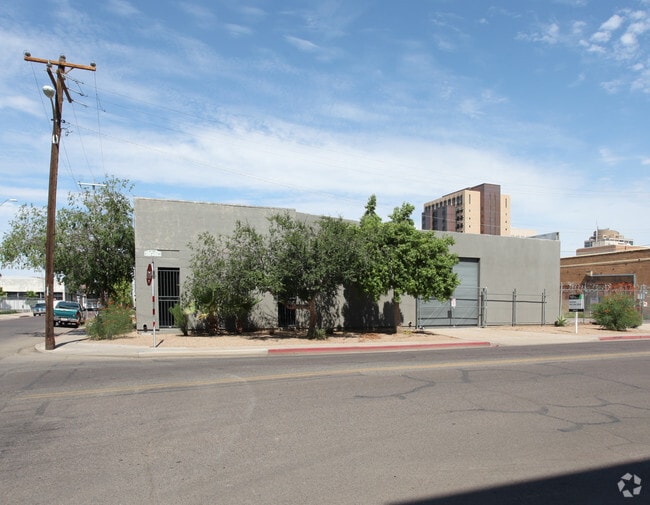
22 E Buchanan St, Phoenix, AZ 85004


Property Detail
22 E Buchanan St
112-26-004A
LINVILLES ADDITION BLOCKS 1 THRU 3 12 THRU 17 26 T MCR 1-10
Warehouse
Maricopa
C-DT
Arizona
C and X Area of minimal flood hazard, usually depicted on FIRMs as above the 500-year flood level.
8
2025
0.57 AC
2025
SC N of Salt River
114200
Phoenix
17,350 SF
Phoenix-Mesa-Chandler, AZ
NEARBY LISTINGS FOR SALE OR LEASE
DEMOGRAPHICS near 22 E Buchanan St
1 mile
3 mile
5 mile
2024 Total Population
19,202
104,833
364,904
2029 Population
20,645
110,846
381,354
Pop Growth 2024-2029
+ 7.51%
+ 5.74%
+ 4.51%
Average Age
36
37
36
2024 Total Households
8,234
41,501
135,492
HH Growth 2024-2029
+ 8.56%
+ 6.06%
+ 4.77%
Median Household Inc
$43,888
$58,148
$62,367
Avg Household Size
1.90
2.30
2.60
2024 Avg HH Vehicles
1.00
1.00
2.00
Median Home Value
$396,580
$431,163
$395,951
Median Year Built
1996
1970
1974
Nearby Places
Map Layers
Map Styles
 Street
 Aerial
Transit
 Traffic
 Biking
Places
Listings with unknown addresses are not visible on the map
- Restaurants
- Banks
- Shops
- Fitness
- Groceries
PUBLIC TRANSPORTATION
TRANSIT/SUBWAY
3Rd St/Jefferson (METRO Light Rail - Valley Metro (Phoenix Light Rail))
Drive
Walk
Distance
3Rd St/Jefferson (METRO Light Rail - Valley Metro (Phoenix Light Rail))
1 min
7 min
0.4 mi
Washington/Central Ave (METRO Light Rail - Valley Metro (Phoenix Light Rail))
Drive
Walk
Distance
Washington/Central Ave (METRO Light Rail - Valley Metro (Phoenix Light Rail))
1 min
8 min
0.4 mi
3Rd St/Washington (METRO Light Rail - Valley Metro (Phoenix Light Rail))
Drive
Walk
Distance
3Rd St/Washington (METRO Light Rail - Valley Metro (Phoenix Light Rail))
2 min
8 min
0.5 mi
Jefferson/1St Ave (METRO Light Rail - Valley Metro (Phoenix Light Rail))
Drive
Walk
Distance
Jefferson/1St Ave (METRO Light Rail - Valley Metro (Phoenix Light Rail))
1 min
8 min
0.5 mi
Van Buren/Central Ave (METRO Light Rail - Valley Metro (Phoenix Light Rail))
Drive
Walk
Distance
Van Buren/Central Ave (METRO Light Rail - Valley Metro (Phoenix Light Rail))
1 min
12 min
0.7 mi
AIRPORT
Phoenix Sky Harbor International
Drive
Walk
Distance
Phoenix Sky Harbor International
11 min
5.4 mi
Phoenix-Mesa Gateway
Drive
Walk
Distance
Phoenix-Mesa Gateway
43 min
32.2 mi
Freight Ports
Port of San Diego
Drive
Walk
Distance
Port of San Diego
397 min
355.9 mi
Nearby Properties
Address
Land Use
TOTAL SIZE
Lot Size
Zoning
Address
Land Use
TOTAL SIZE
Lot Size
Zoning
582,073 SF
1.45 AC
C-C
Address
Land Use
TOTAL SIZE
Lot Size
Zoning
1.85 AC
Address
Land Use
TOTAL SIZE
Lot Size
Zoning
455,443 SF
3.21 AC
C-C
Address
Land Use
TOTAL SIZE
Lot Size
Zoning
997,436 SF
24.84 AC
DC
Address
Land Use
TOTAL SIZE
Lot Size
Zoning
24.15 AC
Address
Land Use
TOTAL SIZE
Lot Size
Zoning
339,909 SF
3 AC
C-C
Address
Land Use
TOTAL SIZE
Lot Size
Zoning
2,568,761 SF
48.36 AC
C-C
Address
Land Use
TOTAL SIZE
Lot Size
Zoning
437,102 SF
1.02 AC
C-2
Address
Land Use
TOTAL SIZE
Lot Size
Zoning
2,334,671 SF
32.63 AC
C-2
Address
Land Use
TOTAL SIZE
Lot Size
Zoning
191,120 SF
1.43 AC
C-C
Address
Land Use
TOTAL SIZE
Lot Size
Zoning
1,636,025 SF
16.50 AC
C-DT
Address
Land Use
TOTAL SIZE
Lot Size
Zoning
1,748,324 SF
29.35 AC
M-H
Address
Land Use
TOTAL SIZE
Lot Size
Zoning
2,705,875 SF
133.42 AC
I-1
Address
Land Use
TOTAL SIZE
Lot Size
Zoning
577,883 SF
2.05 AC
C-DT
Address
Land Use
TOTAL SIZE
Lot Size
Zoning
568,512 SF
6.99 AC
C-DT
Address
Land Use
TOTAL SIZE
Lot Size
Zoning
671,803 SF
2.99 AC
C-DT
Address
Land Use
TOTAL SIZE
Lot Size
Zoning
833,326 SF
1.31 AC
C-DT
Address
Land Use
TOTAL SIZE
Lot Size
Zoning
940,067 SF
12.22 AC
DTCBIO
Address
Land Use
TOTAL SIZE
Lot Size
Zoning
536,452 SF
0.58 AC
C-DT
Address
Land Use
TOTAL SIZE
Lot Size
Zoning
981,015 SF
2.83 AC
C-DT
Address
Land Use
TOTAL SIZE
Lot Size
Zoning
429,457 SF
9.41 AC
C-DT
Address
Land Use
TOTAL SIZE
Lot Size
Zoning
384,291 SF
2.68 AC
C-DT
Address
Land Use
TOTAL SIZE
Lot Size
Zoning
925,428 SF
86.02 AC
M-H
Address
Land Use
TOTAL SIZE
Lot Size
Zoning
Address
Land Use
TOTAL SIZE
Lot Size
Zoning
782,912 SF
1.12 AC
C-DT
Address
Land Use
TOTAL SIZE
Lot Size
Zoning
550,269 SF
2.05 AC
DTCBCORE
Address
Land Use
TOTAL SIZE
Lot Size
Zoning
727,848 SF
0.06 AC
C-DT
Address
Land Use
TOTAL SIZE
Lot Size
Zoning
569,100 SF
0.95 AC
C-DT
Address
Land Use
TOTAL SIZE
Lot Size
Zoning
222,983 SF
1.61 AC
C-DT
Address
Land Use
TOTAL SIZE
Lot Size
Zoning
610,451 SF
4.21 AC
C-C
The World's #1 Commercial Real Estate Marketplace
Connect with us
© 2026 CoStar Group
The information above has been obtained from sources believed reliable. While we do not doubt its accuracy we have not verified it and make no guarantee, warranty or representation about it. It is your responsibility to independently confirm its accuracy and completeness. Any projections, opinions, assumptions, or estimates used are for example only and do not represent the current or future performance of the property. The value of this transaction to you depends on tax and other factors which should be evaluated by your tax, financial, and legal advisors. You and your advisors should conduct a careful, independent investigation of the property to determine to your satisfaction the suitability of the property for your needs.