Property Record
22 Eskow Rd, Worcester, MA 01604
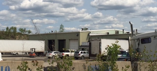

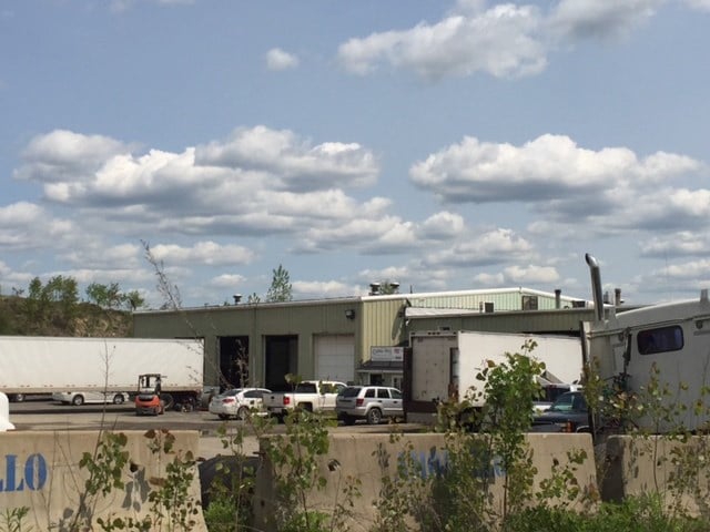
Property Detail
22 Eskow Rd
WORC-000034-000032-000012-000002
Worcester
Autorepair
Massachusetts
MG-2
12-2
B and X Area of moderate flood hazard, usually the area between the limits of the 100-year and 500-year floods.
3.12 AC
2025
Worcester Metro
2025
Boston
732801
Worcester, MA
13,130 SF
NEARBY LISTINGS FOR SALE OR LEASE
DEMOGRAPHICS near 22 Eskow Rd
1 mile
3 mile
5 mile
2025 Total Population
8,167
83,131
214,286
2030 Population
8,414
84,411
217,457
Pop Growth 2025-2030
+ 3.02%
+ 1.54%
+ 1.48%
Average Age
42
39
39
2025 Total Households
3,430
33,633
84,898
HH Growth 2025-2030
+ 3.27%
+ 1.69%
+ 1.61%
Median Household Inc
$98,555
$81,319
$76,698
Avg Household Size
2.30
2.40
2.40
2025 Avg HH Vehicles
2.00
2.00
2.00
Median Home Value
$385,784
$400,283
$422,984
Median Year Built
1975
1957
1955
Nearby Places
Map Layers
Map Styles
 Street
 Aerial
Layers
 Traffic
 Biking
Places
Listings with unknown addresses are not visible on the map
- Restaurants
- Banks
- Shops
- Fitness
- Groceries
PUBLIC TRANSPORTATION
COMMUTER RAIL
Worcester Union Station (Lake Shore Limited - Amtrak)
Drive
Walk
Distance
Worcester Union Station (Lake Shore Limited - Amtrak)
7 min
3.7 mi
Worcester (Framingham/Worcester Line - Massachusetts Bay Transportation Authority Commuter Rail (Purple Line))
Drive
Walk
Distance
Worcester (Framingham/Worcester Line - Massachusetts Bay Transportation Authority Commuter Rail (Purple Line))
7 min
3.8 mi
AIRPORT
Worcester Regional
Drive
Walk
Distance
Worcester Regional
19 min
9.5 mi
Freight Ports
Port of Boston
Drive
Walk
Distance
Port of Boston
58 min
42.4 mi
SALE & LEASE HISTORY
LISTING DATE
SALE/LEASE

Jan 31, 2017
For Sale
Nearby Properties
Address
Land Use
TOTAL SIZE
Lot Size
Zoning
Address
Land Use
TOTAL SIZE
Lot Size
Zoning
612,538 SF
3.98 AC
BG-6
Address
Land Use
TOTAL SIZE
Lot Size
Zoning
43.07 AC
COM BU
Address
Land Use
TOTAL SIZE
Lot Size
Zoning
25,000 SF
99.10 AC
MG-.5
Address
Land Use
TOTAL SIZE
Lot Size
Zoning
311,604 SF
2.37 AC
MG-2
Address
Land Use
TOTAL SIZE
Lot Size
Zoning
272,824 SF
14.95 AC
BL-1
Address
Land Use
TOTAL SIZE
Lot Size
Zoning
19,319 SF
10.67 AC
RG-5
Address
Land Use
TOTAL SIZE
Lot Size
Zoning
176,316 SF
19.57 AC
RL-7
Address
Land Use
TOTAL SIZE
Lot Size
Zoning
70,514 SF
31.64 AC
RL-7
Address
Land Use
TOTAL SIZE
Lot Size
Zoning
591,515 SF
33.04 AC
MG-1
Address
Land Use
TOTAL SIZE
Lot Size
Zoning
210,168 SF
45.75 AC
RL-7
Address
Land Use
TOTAL SIZE
Lot Size
Zoning
159,355 SF
207.62 AC
RL-7
Address
Land Use
TOTAL SIZE
Lot Size
Zoning
68.34 AC
ML10
Address
Land Use
TOTAL SIZE
Lot Size
Zoning
37,093 SF
5.41 AC
RG-5
Address
Land Use
TOTAL SIZE
Lot Size
Zoning
27.89 AC
RL-7
Address
Land Use
TOTAL SIZE
Lot Size
Zoning
64.46 AC
RS-7
Address
Land Use
TOTAL SIZE
Lot Size
Zoning
78.19 AC
RL-7
Address
Land Use
TOTAL SIZE
Lot Size
Zoning
154,200 SF
4.87 AC
BL-1
Address
Land Use
TOTAL SIZE
Lot Size
Zoning
7,700 SF
80.72 AC
ML-.5
Address
Land Use
TOTAL SIZE
Lot Size
Zoning
53.52 AC
RL-7
Address
Land Use
TOTAL SIZE
Lot Size
Zoning
222,474 SF
22.75 AC
MG-1
Address
Land Use
TOTAL SIZE
Lot Size
Zoning
115,117 SF
1.53 AC
BG10
Address
Land Use
TOTAL SIZE
Lot Size
Zoning
93,092 SF
162.83 AC
OLI
Address
Land Use
TOTAL SIZE
Lot Size
Zoning
187,280 SF
1.22 AC
BG-4
Address
Land Use
TOTAL SIZE
Lot Size
Zoning
153,745 SF
10.99 AC
MG-2
Address
Land Use
TOTAL SIZE
Lot Size
Zoning
8.77 AC
BL-1
Address
Land Use
TOTAL SIZE
Lot Size
Zoning
100,143 SF
1.73 AC
BG-3
Address
Land Use
TOTAL SIZE
Lot Size
Zoning
99,600 SF
13.71 AC
RL-7
Address
Land Use
TOTAL SIZE
Lot Size
Zoning
151.20 AC
Address
Land Use
TOTAL SIZE
Lot Size
Zoning
133,482 SF
15.80 AC
BG-2
Address
Land Use
TOTAL SIZE
Lot Size
Zoning
18.10 AC
I1
The World's #1 Commercial Real Estate Marketplace
Connect with us
© 2026 CoStar Group
The information above has been obtained from sources believed reliable. While we do not doubt its accuracy we have not verified it and make no guarantee, warranty or representation about it. It is your responsibility to independently confirm its accuracy and completeness. Any projections, opinions, assumptions, or estimates used are for example only and do not represent the current or future performance of the property. The value of this transaction to you depends on tax and other factors which should be evaluated by your tax, financial, and legal advisors. You and your advisors should conduct a careful, independent investigation of the property to determine to your satisfaction the suitability of the property for your needs.