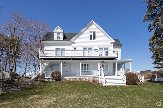
Property Record
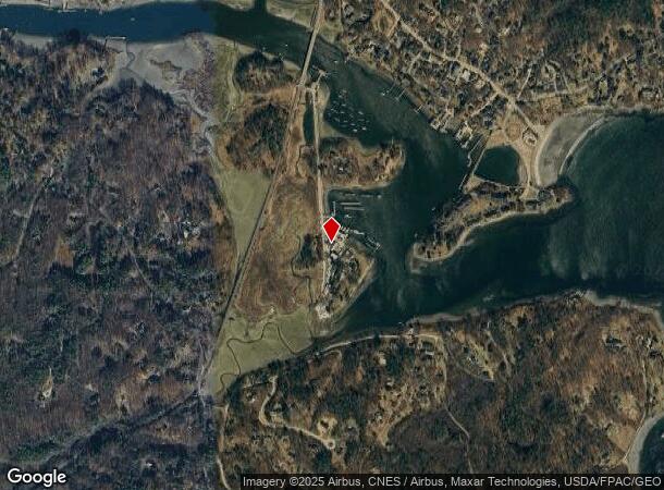
22 Harris Island Rd, York, ME 03909
NEARBY LISTINGS FOR SALE OR LEASE
-
-
View all York listings for sale on LoopNet.com
Property Detail
22 Harris Island Rd
Portland-South Portland, ME
Harris Island Inc
YORK-000063-000000-000002-000001
York
Commercialnec
Maine
AE
1
23031C0669G
6.50 AC
2024
York County
2024
Portland/South Portland
036003
DEMOGRAPHICS near 22 Harris Island Rd
1 Mile
3 Mile
5 Mile
2024 Total Population
1,305
7,679
16,794
2029 Population
1,386
8,099
17,710
Pop Growth 2024-2029
+ 6.21%
+ 5.47%
+ 5.45%
Average Age
51
49
48
2024 Total Households
565
3,344
7,323
HH Growth 2024-2029
+ 6.19%
+ 5.38%
+ 5.39%
Median Household Inc
$77,425
$99,126
$97,595
Avg Household Size
2.20
2.20
2.20
2024 Avg HH Vehicles
2.00
2.00
2.00
Median Home Value
$639,121
$498,774
$478,045
Median Year Built
1975
1979
1976
Nearby Places
Map Layers
Map Styles
 Street
 Aerial
- Restaurants
- Banks
- Shops
- Fitness
- Groceries
PUBLIC TRANSPORTATION
AIRPORT
Portsmouth International at Pease
DRIVE
WALK
Distance
Portsmouth International at Pease
24 min
13.2 mi
Freight Ports
Portland, ME
DRIVE
WALK
Distance
Portland, ME
57 min
45.5 mi
Nearby Properties
Address
Land Use
TOTAL SIZE
Lot Size
Zoning
Address
Land Use
TOTAL SIZE
Lot Size
Zoning
1 AC
B-1
Address
Land Use
TOTAL SIZE
Lot Size
Zoning
12.10 AC
R1B
Address
Land Use
TOTAL SIZE
Lot Size
Zoning
173,499 SF
67.98 AC
G3
Address
Land Use
TOTAL SIZE
Lot Size
Zoning
172,546 SF
13.99 AC
R1B
Address
Land Use
TOTAL SIZE
Lot Size
Zoning
5.82 AC
R7
Address
Land Use
TOTAL SIZE
Lot Size
Zoning
113,242 SF
9.08 AC
B1
Address
Land Use
TOTAL SIZE
Lot Size
Zoning
59,399 SF
23.44 AC
R1-3
Address
Land Use
TOTAL SIZE
Lot Size
Zoning
1,248 SF
6.48 AC
R1-2
Address
Land Use
TOTAL SIZE
Lot Size
Zoning
49,540 SF
22.60 AC
R1B
Address
Land Use
TOTAL SIZE
Lot Size
Zoning
22.33 AC
R1B
Address
Land Use
TOTAL SIZE
Lot Size
Zoning
53,579 SF
1.78 AC
B1
Address
Land Use
TOTAL SIZE
Lot Size
Zoning
5,335 SF
2.85 AC
R4
Address
Land Use
TOTAL SIZE
Lot Size
Zoning
3.24 AC
R4
Address
Land Use
TOTAL SIZE
Lot Size
Zoning
64,335 SF
8.15 AC
R1-3
Address
Land Use
TOTAL SIZE
Lot Size
Zoning
38.89 AC
Address
Land Use
TOTAL SIZE
Lot Size
Zoning
58,608 SF
4.67 AC
Address
Land Use
TOTAL SIZE
Lot Size
Zoning
272 AC
G2
Address
Land Use
TOTAL SIZE
Lot Size
Zoning
30 AC
R1-1
Address
Land Use
TOTAL SIZE
Lot Size
Zoning
5.96 AC
R1-3
Address
Land Use
TOTAL SIZE
Lot Size
Zoning
24,139 SF
3.03 AC
G3
Address
Land Use
TOTAL SIZE
Lot Size
Zoning
7,674 SF
1.64 AC
R4
Address
Land Use
TOTAL SIZE
Lot Size
Zoning
1.89 AC
R4
Address
Land Use
TOTAL SIZE
Lot Size
Zoning
6,696 SF
2 AC
R7
Address
Land Use
TOTAL SIZE
Lot Size
Zoning
184 AC
R-1B
Address
Land Use
TOTAL SIZE
Lot Size
Zoning
13,395 SF
2.23 AC
B2
Address
Land Use
TOTAL SIZE
Lot Size
Zoning
50,064 SF
6.42 AC
R1B
Address
Land Use
TOTAL SIZE
Lot Size
Zoning
3.64 AC
B2
Address
Land Use
TOTAL SIZE
Lot Size
Zoning
12 AC
R1B
Address
Land Use
TOTAL SIZE
Lot Size
Zoning
2,900 SF
19.53 AC
MU
The World's #1 Commercial Real Estate Marketplace
Connect with us
© 2026 CoStar Group
The information above has been obtained from sources believed reliable. While we do not doubt its accuracy we have not verified it and make no guarantee, warranty or representation about it. It is your responsibility to independently confirm its accuracy and completeness. Any projections, opinions, assumptions, or estimates used are for example only and do not represent the current or future performance of the property. The value of this transaction to you depends on tax and other factors which should be evaluated by your tax, financial, and legal advisors. You and your advisors should conduct a careful, independent investigation of the property to determine to your satisfaction the suitability of the property for your needs.