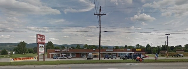
Property Record
22 Highway W, Blairsville, PA 15717

NEARBY LISTINGS FOR SALE OR LEASE
Property Detail
22 Highway W
10-042-205
East Gate Park Plan
Storebuilding
LOT IRREG AC= 3.58 1 CB 1 DR
X
Indiana
42063C0530F
Pennsylvania
2025
3.58 AC
2025
Pennsylvania Central Area
961900
Other Market Areas
10,080 SF
Indiana, PA
DEMOGRAPHICS near 22 Highway W
1 Mile
3 Mile
5 Mile
2024 Total Population
1,014
6,860
9,420
2029 Population
1,012
6,851
9,355
Pop Growth 2024-2029
(0.20%)
(0.13%)
(0.69%)
Average Age
46
45
45
2024 Total Households
450
3,090
4,116
HH Growth 2024-2029
(0.22%)
(0.16%)
(0.70%)
Median Household Inc
$62,027
$52,423
$56,418
Avg Household Size
2.20
2.20
2.20
2024 Avg HH Vehicles
2.00
2.00
2.00
Median Home Value
$159,326
$123,002
$128,390
Median Year Built
1973
1961
1960
Nearby Places
Map Layers
Map Styles
 Street
 Aerial
- Restaurants
- Banks
- Shops
- Fitness
- Groceries
PUBLIC TRANSPORTATION
AIRPORT
Arnold Palmer Regional
DRIVE
WALK
Distance
Arnold Palmer Regional
32 min
18.8 mi
SALE & LEASE HISTORY
LISTING DATE
SALE/LEASE

Sep 25, 2016
For Lease
Oct 23, 2025
For Lease
Feb 02, 2022
For Sale
Nearby Properties
Address
Land Use
TOTAL SIZE
Lot Size
Zoning
Address
Land Use
TOTAL SIZE
Lot Size
Zoning
306.20 AC
Address
Land Use
TOTAL SIZE
Lot Size
Zoning
79,512 SF
33.71 AC
Address
Land Use
TOTAL SIZE
Lot Size
Zoning
1,194 SF
31.38 AC
Address
Land Use
TOTAL SIZE
Lot Size
Zoning
7,524 SF
16.60 AC
Address
Land Use
TOTAL SIZE
Lot Size
Zoning
104,321 SF
8.72 AC
Address
Land Use
TOTAL SIZE
Lot Size
Zoning
18,366 SF
14.75 AC
Address
Land Use
TOTAL SIZE
Lot Size
Zoning
56,654 SF
9.82 AC
Address
Land Use
TOTAL SIZE
Lot Size
Zoning
63,125 SF
2.46 AC
Address
Land Use
TOTAL SIZE
Lot Size
Zoning
12,798 SF
1.56 AC
Address
Land Use
TOTAL SIZE
Lot Size
Zoning
12,798 SF
1.56 AC
Address
Land Use
TOTAL SIZE
Lot Size
Zoning
11,007 SF
5.97 AC
Address
Land Use
TOTAL SIZE
Lot Size
Zoning
3,195 SF
4.50 AC
Address
Land Use
TOTAL SIZE
Lot Size
Zoning
36,364 SF
342.93 AC
Address
Land Use
TOTAL SIZE
Lot Size
Zoning
28,479 SF
4.37 AC
Address
Land Use
TOTAL SIZE
Lot Size
Zoning
26,492 SF
4.47 AC
Address
Land Use
TOTAL SIZE
Lot Size
Zoning
30,237 SF
10.59 AC
Address
Land Use
TOTAL SIZE
Lot Size
Zoning
6,400 SF
4.30 AC
Address
Land Use
TOTAL SIZE
Lot Size
Zoning
6,171 SF
5.81 AC
Address
Land Use
TOTAL SIZE
Lot Size
Zoning
Address
Land Use
TOTAL SIZE
Lot Size
Zoning
13,360 SF
6.34 AC
Address
Land Use
TOTAL SIZE
Lot Size
Zoning
17,100 SF
4.02 AC
Address
Land Use
TOTAL SIZE
Lot Size
Zoning
5,964 SF
2 AC
Address
Land Use
TOTAL SIZE
Lot Size
Zoning
3,783 SF
10.69 AC
Address
Land Use
TOTAL SIZE
Lot Size
Zoning
Address
Land Use
TOTAL SIZE
Lot Size
Zoning
13,863 SF
4.31 AC
Address
Land Use
TOTAL SIZE
Lot Size
Zoning
3,002 SF
1.84 AC
Address
Land Use
TOTAL SIZE
Lot Size
Zoning
10,325 SF
7.36 AC
Address
Land Use
TOTAL SIZE
Lot Size
Zoning
1,320 SF
4.31 AC
Address
Land Use
TOTAL SIZE
Lot Size
Zoning
4,074 SF
3.82 AC
Address
Land Use
TOTAL SIZE
Lot Size
Zoning
7,112 SF
3.45 AC
The World's #1 Commercial Real Estate Marketplace
Connect with us
© 2026 CoStar Group
The information above has been obtained from sources believed reliable. While we do not doubt its accuracy we have not verified it and make no guarantee, warranty or representation about it. It is your responsibility to independently confirm its accuracy and completeness. Any projections, opinions, assumptions, or estimates used are for example only and do not represent the current or future performance of the property. The value of this transaction to you depends on tax and other factors which should be evaluated by your tax, financial, and legal advisors. You and your advisors should conduct a careful, independent investigation of the property to determine to your satisfaction the suitability of the property for your needs.