Property Record
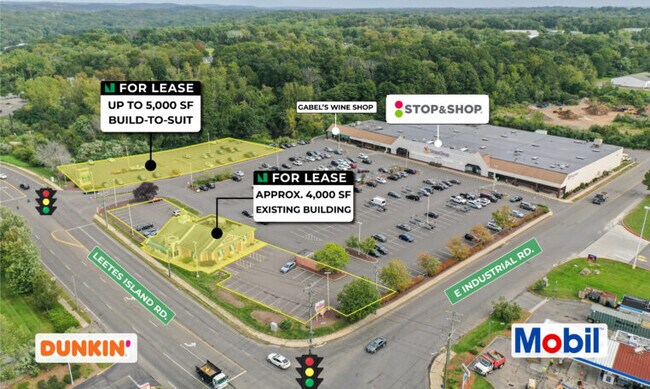
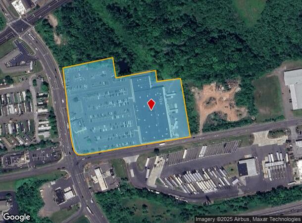
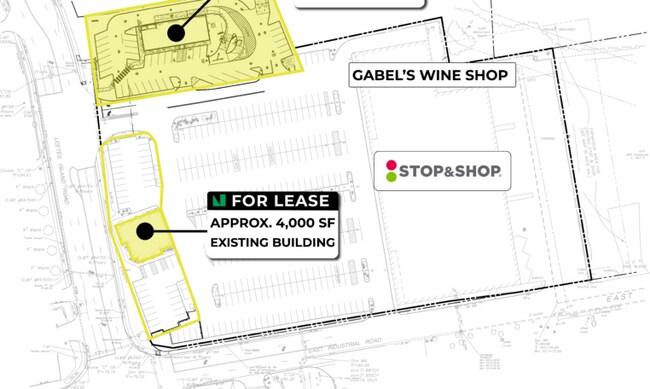
22 Leetes Island Rd, Branford, CT 06405
NEARBY LISTINGS FOR SALE OR LEASE
Property Detail
22 Leetes Island Rd
BRAN-000005H-J000005-000001-000001
New Haven
Commercialnec
Connecticut
X
1
09009C0467K
6.90 AC
2025
Branford
2025
Westchester/So Connecticut
184700
New Haven, CT
DEMOGRAPHICS near 22 Leetes Island Rd
1 Mile
3 Mile
5 Mile
2024 Total Population
1,752
21,426
58,485
2029 Population
1,763
21,461
58,672
Pop Growth 2024-2029
+ 0.63%
+ 0.16%
+ 0.32%
Average Age
47
47
46
2024 Total Households
727
9,519
25,360
HH Growth 2024-2029
+ 0.55%
+ 0.07%
+ 0.28%
Median Household Inc
$130,859
$101,791
$99,600
Avg Household Size
2.40
2.20
2.30
2024 Avg HH Vehicles
2.00
2.00
2.00
Median Home Value
$436,267
$388,644
$364,821
Median Year Built
1978
1973
1972
Nearby Places
Map Layers
Map Styles
 Street
 Aerial
- Restaurants
- Banks
- Shops
- Fitness
- Groceries
PUBLIC TRANSPORTATION
COMMUTER RAIL
Branford (Shore Line East - Shore Line East)
DRIVE
WALK
Distance
Branford (Shore Line East - Shore Line East)
9 min
4.5 mi
DRIVE
WALK
Distance
11 min
6.0 mi
AIRPORT
Tweed/New Haven
DRIVE
WALK
Distance
Tweed/New Haven
13 min
7.5 mi
Freight Ports
Port of New Haven
DRIVE
WALK
Distance
Port of New Haven
13 min
8.1 mi
SALE & LEASE HISTORY
LISTING DATE
SALE/LEASE

Jul 12, 2021
For Lease
Nearby Properties
Address
Land Use
TOTAL SIZE
Lot Size
Zoning
Address
Land Use
TOTAL SIZE
Lot Size
Zoning
30 AC
R-5
Address
Land Use
TOTAL SIZE
Lot Size
Zoning
227,335 SF
38.50 AC
Address
Land Use
TOTAL SIZE
Lot Size
Zoning
88.66 AC
I3
Address
Land Use
TOTAL SIZE
Lot Size
Zoning
175,913 SF
29 AC
Address
Land Use
TOTAL SIZE
Lot Size
Zoning
2,295.68 AC
R80
Address
Land Use
TOTAL SIZE
Lot Size
Zoning
7,065 SF
9.44 AC
Address
Land Use
TOTAL SIZE
Lot Size
Zoning
27.83 AC
SC
Address
Land Use
TOTAL SIZE
Lot Size
Zoning
5.50 AC
Address
Land Use
TOTAL SIZE
Lot Size
Zoning
44,676 SF
7 AC
Address
Land Use
TOTAL SIZE
Lot Size
Zoning
10.30 AC
B1
Address
Land Use
TOTAL SIZE
Lot Size
Zoning
8.29 AC
Address
Land Use
TOTAL SIZE
Lot Size
Zoning
142,136 SF
58.31 AC
R-8
Address
Land Use
TOTAL SIZE
Lot Size
Zoning
2,196 SF
1.68 AC
PRB3
Address
Land Use
TOTAL SIZE
Lot Size
Zoning
10.20 AC
Address
Land Use
TOTAL SIZE
Lot Size
Zoning
2.40 AC
Address
Land Use
TOTAL SIZE
Lot Size
Zoning
13.90 AC
Address
Land Use
TOTAL SIZE
Lot Size
Zoning
54,799 SF
4.06 AC
Address
Land Use
TOTAL SIZE
Lot Size
Zoning
15.10 AC
Address
Land Use
TOTAL SIZE
Lot Size
Zoning
7.69 AC
RU1
Address
Land Use
TOTAL SIZE
Lot Size
Zoning
2.02 AC
Address
Land Use
TOTAL SIZE
Lot Size
Zoning
29.40 AC
Address
Land Use
TOTAL SIZE
Lot Size
Zoning
34,474 SF
2.26 AC
Address
Land Use
TOTAL SIZE
Lot Size
Zoning
5,440 SF
12.44 AC
RGA
Address
Land Use
TOTAL SIZE
Lot Size
Zoning
49,215 SF
2.09 AC
Address
Land Use
TOTAL SIZE
Lot Size
Zoning
29.48 AC
I3
Address
Land Use
TOTAL SIZE
Lot Size
Zoning
695.83 AC
I1
Address
Land Use
TOTAL SIZE
Lot Size
Zoning
Address
Land Use
TOTAL SIZE
Lot Size
Zoning
40,164 SF
11.50 AC
Address
Land Use
TOTAL SIZE
Lot Size
Zoning
45,766 SF
7.71 AC
R-7
The World's #1 Commercial Real Estate Marketplace
Connect with us
© 2026 CoStar Group
The information above has been obtained from sources believed reliable. While we do not doubt its accuracy we have not verified it and make no guarantee, warranty or representation about it. It is your responsibility to independently confirm its accuracy and completeness. Any projections, opinions, assumptions, or estimates used are for example only and do not represent the current or future performance of the property. The value of this transaction to you depends on tax and other factors which should be evaluated by your tax, financial, and legal advisors. You and your advisors should conduct a careful, independent investigation of the property to determine to your satisfaction the suitability of the property for your needs.