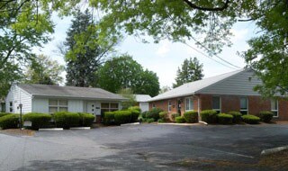
Property Record
22 Millersville Rd, Lancaster, PA 17603


NEARBY LISTINGS FOR SALE OR LEASE
Property Detail
22 Millersville Rd
410-32554-0-0000
22 MILLERSVILLE RD
Commercialnec
Lancaster
X
Pennsylvania
42071C0361F
11a
2024
0.18 AC
2025
Lancaster County
013703
Philadelphia
1,496 SF
Lancaster, PA
DEMOGRAPHICS near 22 Millersville Rd
1 Mile
3 Mile
5 Mile
2024 Total Population
6,960
80,759
173,549
2029 Population
7,016
81,328
174,856
Pop Growth 2024-2029
+ 0.80%
+ 0.70%
+ 0.75%
Average Age
44
40
40
2024 Total Households
2,844
31,314
65,960
HH Growth 2024-2029
+ 0.84%
+ 0.58%
+ 0.68%
Median Household Inc
$72,585
$75,120
$73,156
Avg Household Size
2.40
2.40
2.40
2024 Avg HH Vehicles
2.00
2.00
2.00
Median Home Value
$218,825
$231,352
$235,350
Median Year Built
1965
1968
1967
Nearby Places
Map Layers
Map Styles
 Street
 Aerial
- Restaurants
- Banks
- Shops
- Fitness
- Groceries
PUBLIC TRANSPORTATION
COMMUTER RAIL
DRIVE
WALK
Distance
11 min
4.1 mi
AIRPORT
Harrisburg International
DRIVE
WALK
Distance
Harrisburg International
43 min
31.1 mi
Freight Ports
Port Newark Container Terminal
DRIVE
WALK
Distance
Port Newark Container Terminal
81 min
48.2 mi
Nearby Properties
Address
Land Use
TOTAL SIZE
Lot Size
Zoning
Address
Land Use
TOTAL SIZE
Lot Size
Zoning
822,920 SF
97.54 AC
HCD
Address
Land Use
TOTAL SIZE
Lot Size
Zoning
1,603,151 SF
104.89 AC
C3
Address
Land Use
TOTAL SIZE
Lot Size
Zoning
1,003,686 SF
127.66 AC
HR
Address
Land Use
TOTAL SIZE
Lot Size
Zoning
712,737 SF
52.50 AC
R2
Address
Land Use
TOTAL SIZE
Lot Size
Zoning
243,960 SF
39.27 AC
Address
Land Use
TOTAL SIZE
Lot Size
Zoning
941,905 SF
141.50 AC
I
Address
Land Use
TOTAL SIZE
Lot Size
Zoning
224,054 SF
71 AC
Address
Land Use
TOTAL SIZE
Lot Size
Zoning
308,727 SF
11.37 AC
Address
Land Use
TOTAL SIZE
Lot Size
Zoning
307,696 SF
29 AC
R1
Address
Land Use
TOTAL SIZE
Lot Size
Zoning
193,864 SF
9 AC
Address
Land Use
TOTAL SIZE
Lot Size
Zoning
288,628 SF
27.80 AC
R1A
Address
Land Use
TOTAL SIZE
Lot Size
Zoning
269,890 SF
57.10 AC
SR
Address
Land Use
TOTAL SIZE
Lot Size
Zoning
135,998 SF
28.64 AC
HR
Address
Land Use
TOTAL SIZE
Lot Size
Zoning
691,290 SF
3 AC
Address
Land Use
TOTAL SIZE
Lot Size
Zoning
372,708 SF
50.40 AC
HR
Address
Land Use
TOTAL SIZE
Lot Size
Zoning
128,939 SF
27.39 AC
Address
Land Use
TOTAL SIZE
Lot Size
Zoning
101,558 SF
28.14 AC
AH
Address
Land Use
TOTAL SIZE
Lot Size
Zoning
199,107 SF
26.20 AC
CC
Address
Land Use
TOTAL SIZE
Lot Size
Zoning
138,618 SF
9.53 AC
Address
Land Use
TOTAL SIZE
Lot Size
Zoning
385,561 SF
27.20 AC
Address
Land Use
TOTAL SIZE
Lot Size
Zoning
299,600 SF
63 AC
HR
Address
Land Use
TOTAL SIZE
Lot Size
Zoning
10 SF
14.11 AC
CM
Address
Land Use
TOTAL SIZE
Lot Size
Zoning
244,568 SF
8.30 AC
IN
Address
Land Use
TOTAL SIZE
Lot Size
Zoning
123,664 SF
1.60 AC
R1A
Address
Land Use
TOTAL SIZE
Lot Size
Zoning
1,382,541 SF
106.20 AC
Address
Land Use
TOTAL SIZE
Lot Size
Zoning
198,577 SF
2.88 AC
Address
Land Use
TOTAL SIZE
Lot Size
Zoning
113,967 SF
13.32 AC
Address
Land Use
TOTAL SIZE
Lot Size
Zoning
75,766 SF
9.07 AC
Address
Land Use
TOTAL SIZE
Lot Size
Zoning
76,318 SF
15.17 AC
Address
Land Use
TOTAL SIZE
Lot Size
Zoning
826,042 SF
57.40 AC
CM
The World's #1 Commercial Real Estate Marketplace
Connect with us
© 2026 CoStar Group
The information above has been obtained from sources believed reliable. While we do not doubt its accuracy we have not verified it and make no guarantee, warranty or representation about it. It is your responsibility to independently confirm its accuracy and completeness. Any projections, opinions, assumptions, or estimates used are for example only and do not represent the current or future performance of the property. The value of this transaction to you depends on tax and other factors which should be evaluated by your tax, financial, and legal advisors. You and your advisors should conduct a careful, independent investigation of the property to determine to your satisfaction the suitability of the property for your needs.