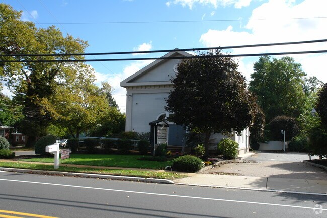
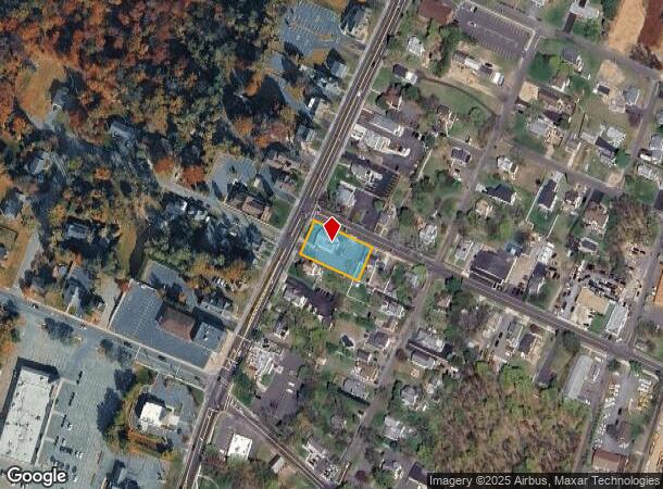
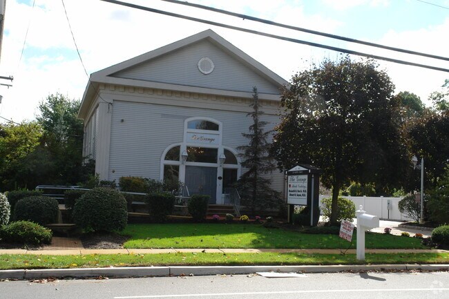
Property Record
22 N Main St, Marlboro, NJ 07746

NEARBY LISTINGS FOR SALE OR LEASE
Property Detail
22 N Main St
30-00222-0000-00009
O C Herbert Prop
Officebuilding
Monmouth
X
New Jersey
34025C0153F
9
2024
0.40 AC
2025
Western Monmouth
809701
Northern New Jersey
3,329 SF
Lakewood-New Brunswick, NJ
DEMOGRAPHICS near 22 N Main St
1 mile
3 mile
5 mile
2024 Total Population
4,591
35,095
96,443
2029 Population
4,513
34,504
95,184
Pop Growth 2024-2029
(1.70%)
(1.68%)
(1.31%)
Average Age
41
42
42
2024 Total Households
1,436
11,232
32,429
HH Growth 2024-2029
(1.95%)
(1.88%)
(1.44%)
Median Household Inc
$175,728
$186,414
$142,364
Avg Household Size
3.10
3.00
2.90
2024 Avg HH Vehicles
2.00
2.00
2.00
Median Home Value
$653,244
$679,913
$618,939
Median Year Built
1982
1982
1981
Nearby Places
Map Layers
Map Styles
 Street
 Aerial
Transit
 Traffic
 Biking
Places
Listings with unknown addresses are not visible on the map
- Restaurants
- Banks
- Shops
- Fitness
- Groceries
PUBLIC TRANSPORTATION
COMMUTER RAIL
Aberdeen Matawan (North Jersey Coast Line - NJ Transit Commuter Rail (NJ Transit))
Drive
Walk
Distance
Aberdeen Matawan (North Jersey Coast Line - NJ Transit Commuter Rail (NJ Transit))
12 min
7.6 mi
Hazlet (North Jersey Coast Line - NJ Transit Commuter Rail (NJ Transit))
Drive
Walk
Distance
Hazlet (North Jersey Coast Line - NJ Transit Commuter Rail (NJ Transit))
16 min
8.7 mi
AIRPORT
Newark Liberty International
Drive
Walk
Distance
Newark Liberty International
49 min
34.5 mi
Trenton Mercer
Drive
Walk
Distance
Trenton Mercer
60 min
38.3 mi
Freight Ports
New York Container Terminal
Drive
Walk
Distance
New York Container Terminal
42 min
29.8 mi
Nearby Properties
Address
Land Use
TOTAL SIZE
Lot Size
Zoning
Address
Land Use
TOTAL SIZE
Lot Size
Zoning
93.79 AC
R-60
Address
Land Use
TOTAL SIZE
Lot Size
Zoning
1,800 SF
83.93 AC
R120
Address
Land Use
TOTAL SIZE
Lot Size
Zoning
46 AC
CF
Address
Land Use
TOTAL SIZE
Lot Size
Zoning
30.80 AC
CF
Address
Land Use
TOTAL SIZE
Lot Size
Zoning
98,617 SF
10 AC
A/LC
Address
Land Use
TOTAL SIZE
Lot Size
Zoning
65,708 SF
13.65 AC
C-5
Address
Land Use
TOTAL SIZE
Lot Size
Zoning
17,342 SF
64.55 AC
ROS
Address
Land Use
TOTAL SIZE
Lot Size
Zoning
21.35 AC
CF
Address
Land Use
TOTAL SIZE
Lot Size
Zoning
0.90 AC
R-1
Address
Land Use
TOTAL SIZE
Lot Size
Zoning
1,800 SF
39.45 AC
R120
Address
Land Use
TOTAL SIZE
Lot Size
Zoning
10,129 SF
1.90 AC
AG
Address
Land Use
TOTAL SIZE
Lot Size
Zoning
10.02 AC
Address
Land Use
TOTAL SIZE
Lot Size
Zoning
34.52 AC
R-60
Address
Land Use
TOTAL SIZE
Lot Size
Zoning
18,117 SF
23.90 AC
Address
Land Use
TOTAL SIZE
Lot Size
Zoning
33.73 AC
R-60
Address
Land Use
TOTAL SIZE
Lot Size
Zoning
411 AC
ROS
Address
Land Use
TOTAL SIZE
Lot Size
Zoning
16.30 AC
R20
Address
Land Use
TOTAL SIZE
Lot Size
Zoning
35,229 SF
17.64 AC
CF
Address
Land Use
TOTAL SIZE
Lot Size
Zoning
27.87 AC
A-1
Address
Land Use
TOTAL SIZE
Lot Size
Zoning
60,436 SF
9.23 AC
C-2
Address
Land Use
TOTAL SIZE
Lot Size
Zoning
30.82 AC
R-60
Address
Land Use
TOTAL SIZE
Lot Size
Zoning
50,970 SF
4.32 AC
C2
Address
Land Use
TOTAL SIZE
Lot Size
Zoning
16,803 SF
19.87 AC
R302
Address
Land Use
TOTAL SIZE
Lot Size
Zoning
28.10 AC
R-25
Address
Land Use
TOTAL SIZE
Lot Size
Zoning
15.17 AC
A-1
Address
Land Use
TOTAL SIZE
Lot Size
Zoning
30,350 SF
7.02 AC
C2
Address
Land Use
TOTAL SIZE
Lot Size
Zoning
48,088 SF
7.40 AC
C-3
Address
Land Use
TOTAL SIZE
Lot Size
Zoning
7.84 AC
LI
Address
Land Use
TOTAL SIZE
Lot Size
Zoning
360.97 AC
ROS
Address
Land Use
TOTAL SIZE
Lot Size
Zoning
25.02 AC
R-20
The World's #1 Commercial Real Estate Marketplace
Connect with us
© 2026 CoStar Group
The information above has been obtained from sources believed reliable. While we do not doubt its accuracy we have not verified it and make no guarantee, warranty or representation about it. It is your responsibility to independently confirm its accuracy and completeness. Any projections, opinions, assumptions, or estimates used are for example only and do not represent the current or future performance of the property. The value of this transaction to you depends on tax and other factors which should be evaluated by your tax, financial, and legal advisors. You and your advisors should conduct a careful, independent investigation of the property to determine to your satisfaction the suitability of the property for your needs.