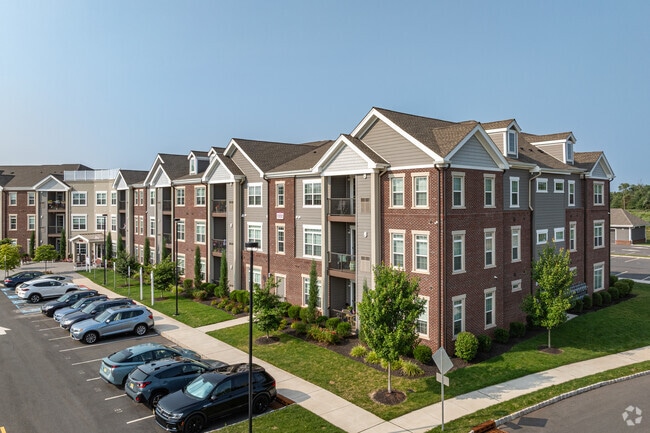
Property Record
22 Scarborough Rd, Belle Mead, NJ 08502


NEARBY LISTINGS FOR SALE OR LEASE
-
-
View all Belle Mead listings for sale on LoopNet.com
Property Detail
22 Scarborough Rd
Newark, NJ-PA
ADDITIONAL LOTS: SENIOR APT. BUILDING
13-04020-0000-00001
Somerset
Apartment
New Jersey
X
1
34035C0233E
23.70 AC
2024
Outlying Somerset County
2025
Northern New Jersey
054202
DEMOGRAPHICS near 22 Scarborough Rd
1 Mile
3 Mile
5 Mile
2024 Total Population
5,564
27,995
63,194
2029 Population
5,598
28,118
63,350
Pop Growth 2024-2029
+ 0.61%
+ 0.44%
+ 0.25%
Average Age
38
40
41
2024 Total Households
1,914
9,866
21,867
HH Growth 2024-2029
+ 0.47%
+ 0.39%
+ 0.21%
Median Household Inc
$190,635
$172,181
$166,778
Avg Household Size
2.90
2.80
2.80
2024 Avg HH Vehicles
2.00
2.00
2.00
Median Home Value
$687,258
$574,299
$581,517
Median Year Built
1996
1986
1987
Nearby Places
Map Layers
Map Styles
 Street
 Aerial
- Restaurants
- Banks
- Shops
- Fitness
- Groceries
PUBLIC TRANSPORTATION
COMMUTER RAIL
Somerville (Raritan Valley Line - NJ Transit Commuter Rail (NJ Transit))
DRIVE
WALK
Distance
Somerville (Raritan Valley Line - NJ Transit Commuter Rail (NJ Transit))
13 min
8.3 mi
Raritan (Raritan Valley Line - NJ Transit Commuter Rail (NJ Transit))
DRIVE
WALK
Distance
Raritan (Raritan Valley Line - NJ Transit Commuter Rail (NJ Transit))
14 min
9.5 mi
AIRPORT
Trenton Mercer
DRIVE
WALK
Distance
Trenton Mercer
37 min
21.5 mi
Freight Ports
New York Container Terminal
DRIVE
WALK
Distance
New York Container Terminal
53 min
37.9 mi
Nearby Properties
Address
Land Use
TOTAL SIZE
Lot Size
Zoning
Address
Land Use
TOTAL SIZE
Lot Size
Zoning
289,939 SF
27.31 AC
MUID
Address
Land Use
TOTAL SIZE
Lot Size
Zoning
61,757 SF
8.75 AC
TC
Address
Land Use
TOTAL SIZE
Lot Size
Zoning
Address
Land Use
TOTAL SIZE
Lot Size
Zoning
48 AC
R1
Address
Land Use
TOTAL SIZE
Lot Size
Zoning
111,204 SF
26.68 AC
PD
Address
Land Use
TOTAL SIZE
Lot Size
Zoning
780 SF
9.89 AC
GA
Address
Land Use
TOTAL SIZE
Lot Size
Zoning
1,440 SF
19.33 AC
TC
Address
Land Use
TOTAL SIZE
Lot Size
Zoning
11.58 AC
R1
Address
Land Use
TOTAL SIZE
Lot Size
Zoning
28.22 AC
Address
Land Use
TOTAL SIZE
Lot Size
Zoning
1,096 SF
17.75 AC
TC
Address
Land Use
TOTAL SIZE
Lot Size
Zoning
413,403 SF
68.15 AC
LI
Address
Land Use
TOTAL SIZE
Lot Size
Zoning
179,680 SF
40.66 AC
RD
Address
Land Use
TOTAL SIZE
Lot Size
Zoning
1,525 AC
MZ
Address
Land Use
TOTAL SIZE
Lot Size
Zoning
9.98 AC
R1
Address
Land Use
TOTAL SIZE
Lot Size
Zoning
11.40 AC
R1
Address
Land Use
TOTAL SIZE
Lot Size
Zoning
6.31 AC
R1
Address
Land Use
TOTAL SIZE
Lot Size
Zoning
478.38 AC
MR
Address
Land Use
TOTAL SIZE
Lot Size
Zoning
12.90 AC
TC
Address
Land Use
TOTAL SIZE
Lot Size
Zoning
Address
Land Use
TOTAL SIZE
Lot Size
Zoning
Address
Land Use
TOTAL SIZE
Lot Size
Zoning
666 SF
7.43 AC
GA
Address
Land Use
TOTAL SIZE
Lot Size
Zoning
3.40 AC
GA
Address
Land Use
TOTAL SIZE
Lot Size
Zoning
10,580 SF
4.86 AC
PD
Address
Land Use
TOTAL SIZE
Lot Size
Zoning
10.86 AC
R1
Address
Land Use
TOTAL SIZE
Lot Size
Zoning
71.60 AC
R1
Address
Land Use
TOTAL SIZE
Lot Size
Zoning
84,108 SF
14.50 AC
LI
Address
Land Use
TOTAL SIZE
Lot Size
Zoning
21.86 AC
R1
Address
Land Use
TOTAL SIZE
Lot Size
Zoning
1,204 SF
6.84 AC
GA
Address
Land Use
TOTAL SIZE
Lot Size
Zoning
1,912 SF
10.11 AC
GB
The World's #1 Commercial Real Estate Marketplace
Connect with us
© 2025 CoStar Group
The information above has been obtained from sources believed reliable. While we do not doubt its accuracy we have not verified it and make no guarantee, warranty or representation about it. It is your responsibility to independently confirm its accuracy and completeness. Any projections, opinions, assumptions, or estimates used are for example only and do not represent the current or future performance of the property. The value of this transaction to you depends on tax and other factors which should be evaluated by your tax, financial, and legal advisors. You and your advisors should conduct a careful, independent investigation of the property to determine to your satisfaction the suitability of the property for your needs.