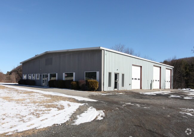
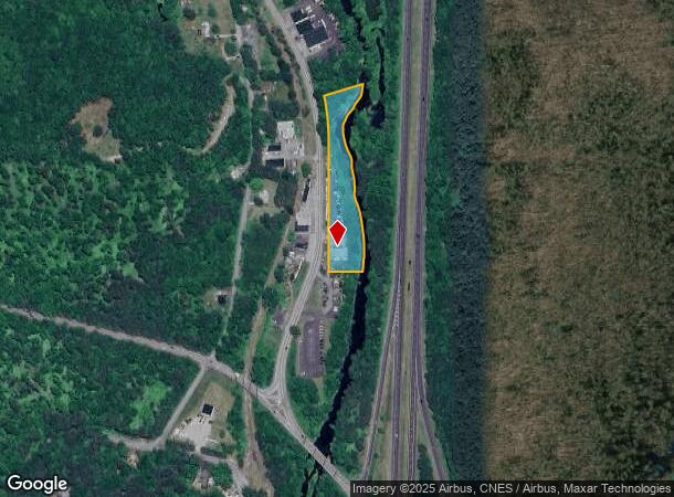
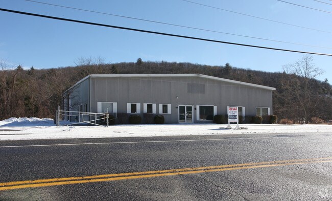
Property Record
22 Thomaston Rd, Litchfield, CT 06759
NEARBY LISTINGS FOR SALE OR LEASE
Property Detail
22 Thomaston Rd
Torrington, CT
Litchfield
LITC-000130-000001C-000017A
Connecticut
Commercialbuilding
17a
2025
2 AC
2025
Torrington
300400
Hartford
6,400 SF
DEMOGRAPHICS near 22 Thomaston Rd
1 mile
3 mile
5 mile
2024 Total Population
428
19,331
40,943
2029 Population
432
19,286
40,782
Pop Growth 2024-2029
+ 0.93%
(0.23%)
(0.39%)
Average Age
45
43
44
2024 Total Households
175
8,479
17,679
HH Growth 2024-2029
+ 0.57%
(0.24%)
(0.37%)
Median Household Inc
$104,687
$64,969
$69,223
Avg Household Size
2.40
2.20
2.20
2024 Avg HH Vehicles
2.00
2.00
2.00
Median Home Value
$332,894
$194,056
$205,984
Median Year Built
1961
1952
1958
Nearby Places
Map Layers
Map Styles
 Street
 Aerial
Transit
 Traffic
 Biking
Places
Listings with unknown addresses are not visible on the map
- Restaurants
- Banks
- Shops
- Fitness
- Groceries
PUBLIC TRANSPORTATION
AIRPORT
Bradley International
Drive
Walk
Distance
Bradley International
65 min
37.9 mi
Tweed/New Haven
Drive
Walk
Distance
Tweed/New Haven
65 min
43.9 mi
Freight Ports
Port of New Haven
Drive
Walk
Distance
Port of New Haven
59 min
41.8 mi
Nearby Properties
Address
Land Use
TOTAL SIZE
Lot Size
Zoning
Address
Land Use
TOTAL SIZE
Lot Size
Zoning
119.90 AC
R6
Address
Land Use
TOTAL SIZE
Lot Size
Zoning
169,551 SF
3.49 AC
I
Address
Land Use
TOTAL SIZE
Lot Size
Zoning
85,628 SF
4.25 AC
R6
Address
Land Use
TOTAL SIZE
Lot Size
Zoning
111,459 SF
16.72 AC
R15
Address
Land Use
TOTAL SIZE
Lot Size
Zoning
15.03 AC
DD
Address
Land Use
TOTAL SIZE
Lot Size
Zoning
42,676 SF
3.19 AC
R6
Address
Land Use
TOTAL SIZE
Lot Size
Zoning
58.50 AC
RR
Address
Land Use
TOTAL SIZE
Lot Size
Zoning
39,111 SF
0.63 AC
DD-R
Address
Land Use
TOTAL SIZE
Lot Size
Zoning
396.22 AC
R-1
Address
Land Use
TOTAL SIZE
Lot Size
Zoning
124,360 SF
4.30 AC
DD
Address
Land Use
TOTAL SIZE
Lot Size
Zoning
68,192 SF
1.76 AC
DD
Address
Land Use
TOTAL SIZE
Lot Size
Zoning
131,925 SF
12.51 AC
DD
Address
Land Use
TOTAL SIZE
Lot Size
Zoning
24,768 SF
1.67 AC
DD
Address
Land Use
TOTAL SIZE
Lot Size
Zoning
3.90 AC
B1
Address
Land Use
TOTAL SIZE
Lot Size
Zoning
7,200 SF
0.27 AC
DD
Address
Land Use
TOTAL SIZE
Lot Size
Zoning
1 AC
DD
Address
Land Use
TOTAL SIZE
Lot Size
Zoning
4.70 AC
I
Address
Land Use
TOTAL SIZE
Lot Size
Zoning
57,875 SF
21.83 AC
CRA-2
Address
Land Use
TOTAL SIZE
Lot Size
Zoning
40.65 AC
Address
Land Use
TOTAL SIZE
Lot Size
Zoning
8.10 AC
R6
Address
Land Use
TOTAL SIZE
Lot Size
Zoning
21,654 SF
0.53 AC
DD
Address
Land Use
TOTAL SIZE
Lot Size
Zoning
20,873 SF
0.54 AC
DD
Address
Land Use
TOTAL SIZE
Lot Size
Zoning
22,852 SF
10.99 AC
RR, GR
Address
Land Use
TOTAL SIZE
Lot Size
Zoning
14,405 SF
1.50 AC
DD
Address
Land Use
TOTAL SIZE
Lot Size
Zoning
4,813 SF
1.06 AC
R6
Address
Land Use
TOTAL SIZE
Lot Size
Zoning
36.63 AC
RR
Address
Land Use
TOTAL SIZE
Lot Size
Zoning
42,771 SF
1.40 AC
DD
Address
Land Use
TOTAL SIZE
Lot Size
Zoning
24,385 SF
2.28 AC
R6
Address
Land Use
TOTAL SIZE
Lot Size
Zoning
7.36 AC
R10S
Address
Land Use
TOTAL SIZE
Lot Size
Zoning
154,553 SF
4.36 AC
DD
The World's #1 Commercial Real Estate Marketplace
Connect with us
© 2026 CoStar Group
The information above has been obtained from sources believed reliable. While we do not doubt its accuracy we have not verified it and make no guarantee, warranty or representation about it. It is your responsibility to independently confirm its accuracy and completeness. Any projections, opinions, assumptions, or estimates used are for example only and do not represent the current or future performance of the property. The value of this transaction to you depends on tax and other factors which should be evaluated by your tax, financial, and legal advisors. You and your advisors should conduct a careful, independent investigation of the property to determine to your satisfaction the suitability of the property for your needs.