Property Record
22 Turtle Creek Cir, Swanton, OH 43558

NEARBY LISTINGS FOR SALE OR LEASE
-
-
View all Swanton listings for lease on LoopNet.com
Property Detail
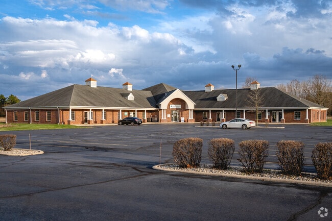
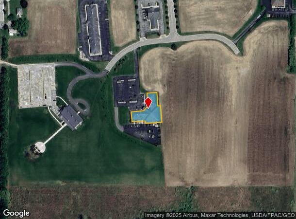
22 Turtle Creek Cir
Toledo, OH
Turtle Creek Medical Compl Ex
75-08834
TURTLE CREEK MEDICAL COMPL EX LOT 2 & UNDIVIDED 39.89% INTEREST IN LOT A
Medicalbuilding
Lucas
X
Ohio
39095C0185E
2,a
0
0.44 AC
2025
South/Southwest
009500
Toledo
15,972 SF
DEMOGRAPHICS near 22 Turtle Creek Cir
1 Mile
3 Mile
5 Mile
2024 Total Population
1,584
7,116
13,712
2029 Population
1,568
7,037
13,468
Pop Growth 2024-2029
(1.01%)
(1.11%)
(1.78%)
Average Age
43
43
43
2024 Total Households
617
2,801
5,387
HH Growth 2024-2029
(1.13%)
(1.18%)
(1.84%)
Median Household Inc
$69,818
$70,166
$71,853
Avg Household Size
2.50
2.50
2.50
2024 Avg HH Vehicles
2.00
2.00
2.00
Median Home Value
$174,206
$176,697
$189,255
Median Year Built
1969
1969
1972
Nearby Places
Map Layers
Map Styles
 Street
 Aerial
- Restaurants
- Banks
- Shops
- Fitness
- Groceries
PUBLIC TRANSPORTATION
AIRPORT
Eugene F Kranz Toledo Express
DRIVE
WALK
Distance
Eugene F Kranz Toledo Express
14 min
4.8 mi
SALE & LEASE HISTORY
LISTING DATE
SALE/LEASE

Sep 25, 2016
For Lease
Sep 08, 2024
For Lease
Mar 07, 2023
For Lease
Mar 07, 2023
For Sale
Feb 21, 2023
For Lease
Feb 21, 2023
For Sale
Nearby Properties
Address
Land Use
TOTAL SIZE
Lot Size
Zoning
Address
Land Use
TOTAL SIZE
Lot Size
Zoning
122,761 SF
49.24 AC
R1
Address
Land Use
TOTAL SIZE
Lot Size
Zoning
8,571 SF
43.96 AC
18-R1
Address
Land Use
TOTAL SIZE
Lot Size
Zoning
228.67 AC
33-MX
Address
Land Use
TOTAL SIZE
Lot Size
Zoning
42,170 SF
6.55 AC
R2
Address
Land Use
TOTAL SIZE
Lot Size
Zoning
25,714 SF
4.80 AC
R2
Address
Land Use
TOTAL SIZE
Lot Size
Zoning
33,716 SF
2.76 AC
B3
Address
Land Use
TOTAL SIZE
Lot Size
Zoning
22,634 SF
9.43 AC
R1
Address
Land Use
TOTAL SIZE
Lot Size
Zoning
26,838 SF
22.67 AC
R2
Address
Land Use
TOTAL SIZE
Lot Size
Zoning
58,438 SF
398.85 AC
33-A
Address
Land Use
TOTAL SIZE
Lot Size
Zoning
23,318 SF
8.71 AC
B3
Address
Land Use
TOTAL SIZE
Lot Size
Zoning
4,800 SF
4.05 AC
B3
Address
Land Use
TOTAL SIZE
Lot Size
Zoning
21,284 SF
111.40 AC
18-B3
Address
Land Use
TOTAL SIZE
Lot Size
Zoning
39,924 SF
1.63 AC
33-A
Address
Land Use
TOTAL SIZE
Lot Size
Zoning
9,920 SF
26.76 AC
18-B3
Address
Land Use
TOTAL SIZE
Lot Size
Zoning
4,733 SF
41.71 AC
18-A
Address
Land Use
TOTAL SIZE
Lot Size
Zoning
54,293 SF
4.96 AC
B3
Address
Land Use
TOTAL SIZE
Lot Size
Zoning
43,300 SF
10.58 AC
M2
Address
Land Use
TOTAL SIZE
Lot Size
Zoning
26,768 SF
65.40 AC
Address
Land Use
TOTAL SIZE
Lot Size
Zoning
10,000 SF
10.72 AC
M1
Address
Land Use
TOTAL SIZE
Lot Size
Zoning
79,400 SF
28.04 AC
33-MX
Address
Land Use
TOTAL SIZE
Lot Size
Zoning
16,016 SF
1 AC
18-B3
Address
Land Use
TOTAL SIZE
Lot Size
Zoning
11,625 SF
0.55 AC
R2
Address
Land Use
TOTAL SIZE
Lot Size
Zoning
25,588 SF
4.31 AC
18-B3
Address
Land Use
TOTAL SIZE
Lot Size
Zoning
11,068 SF
1.43 AC
B3
Address
Land Use
TOTAL SIZE
Lot Size
Zoning
87,090 SF
10.93 AC
33-M1
Address
Land Use
TOTAL SIZE
Lot Size
Zoning
Address
Land Use
TOTAL SIZE
Lot Size
Zoning
151.53 AC
33-A
Address
Land Use
TOTAL SIZE
Lot Size
Zoning
134.03 AC
33-A
Address
Land Use
TOTAL SIZE
Lot Size
Zoning
13,880 SF
1.20 AC
18-B3
Address
Land Use
TOTAL SIZE
Lot Size
Zoning
24,542 SF
6.29 AC
The World's #1 Commercial Real Estate Marketplace
Connect with us
© 2026 CoStar Group
The information above has been obtained from sources believed reliable. While we do not doubt its accuracy we have not verified it and make no guarantee, warranty or representation about it. It is your responsibility to independently confirm its accuracy and completeness. Any projections, opinions, assumptions, or estimates used are for example only and do not represent the current or future performance of the property. The value of this transaction to you depends on tax and other factors which should be evaluated by your tax, financial, and legal advisors. You and your advisors should conduct a careful, independent investigation of the property to determine to your satisfaction the suitability of the property for your needs.