Property Record
22 Wallkill Ave, Wallkill, NY 12589

Save to a Folder
{{folder.Name}}
{{folder.ListingIds.length}} Properties
{{folder.ListingIds.length}} Property
Create a New Folder
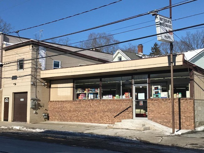
Property Detail
22 Wallkill Ave
5200-106.049-0003-034.000-0000
Orange
Commercialbuilding
New York
SB
34.000
B and X Area of moderate flood hazard, usually the area between the limits of the 100-year and 500-year floods.
0.06 AC
2025
Hudson Valley Area
2025
Other Market Areas
955400
Kingston, NY
2,352 SF
NEARBY LISTINGS FOR SALE OR LEASE
-
-
View all Wallkill listings for lease on LoopNet.com
DEMOGRAPHICS near 22 Wallkill Ave
1 mile
3 mile
5 mile
2025 Total Population
1,640
10,557
25,509
2030 Population
1,601
10,603
25,615
Pop Growth 2025-2030
(2.38%)
+ 0.44%
+ 0.42%
Average Age
41
41
41
2025 Total Households
631
3,507
8,621
HH Growth 2025-2030
(2.38%)
+ 0.31%
+ 0.35%
Median Household Inc
$95,993
$101,790
$108,505
Avg Household Size
2.60
2.70
2.70
2025 Avg HH Vehicles
2.00
2.00
2.00
Median Home Value
$414,935
$397,144
$387,912
Median Year Built
1974
1974
1974
Nearby Places
Map Layers
Map Styles
 Street
 Aerial
Layers
 Traffic
 Biking
Places
Listings with unknown addresses are not visible on the map
- Restaurants
- Banks
- Shops
- Fitness
- Groceries
PUBLIC TRANSPORTATION
AIRPORT
New York Stewart International
Drive
Walk
Distance
New York Stewart International
23 min
13.7 mi
SALE & LEASE HISTORY
LISTING DATE
SALE/LEASE

Feb 04, 2019
For Lease
Feb 03, 2019
For Sale
Nearby Properties
Address
Land Use
TOTAL SIZE
Lot Size
Zoning
Address
Land Use
TOTAL SIZE
Lot Size
Zoning
93.10 AC
RA-.5
Address
Land Use
TOTAL SIZE
Lot Size
Zoning
109,108 SF
15.60 AC
B2
Address
Land Use
TOTAL SIZE
Lot Size
Zoning
84.40 AC
RA-.5
Address
Land Use
TOTAL SIZE
Lot Size
Zoning
14,376 SF
63.90 AC
01
Address
Land Use
TOTAL SIZE
Lot Size
Zoning
18,386 SF
54.70 AC
RA-.5
Address
Land Use
TOTAL SIZE
Lot Size
Zoning
38.80 AC
H-1
Address
Land Use
TOTAL SIZE
Lot Size
Zoning
111,517 SF
6.11 AC
R3
Address
Land Use
TOTAL SIZE
Lot Size
Zoning
35.80 AC
I1
Address
Land Use
TOTAL SIZE
Lot Size
Zoning
34.20 AC
Address
Land Use
TOTAL SIZE
Lot Size
Zoning
51,257 SF
8.50 AC
RM1
Address
Land Use
TOTAL SIZE
Lot Size
Zoning
100.90 AC
RAG-2
Address
Land Use
TOTAL SIZE
Lot Size
Zoning
36,648 SF
3.10 AC
R4
Address
Land Use
TOTAL SIZE
Lot Size
Zoning
92,537 SF
3.80 AC
H-1
Address
Land Use
TOTAL SIZE
Lot Size
Zoning
32,219 SF
5 AC
R3
Address
Land Use
TOTAL SIZE
Lot Size
Zoning
3,664 SF
133.20 AC
RA5
Address
Land Use
TOTAL SIZE
Lot Size
Zoning
63,710 SF
26.30 AC
H-1
Address
Land Use
TOTAL SIZE
Lot Size
Zoning
9,224 SF
3.60 AC
B4
Address
Land Use
TOTAL SIZE
Lot Size
Zoning
2,520 SF
45.90 AC
B4
Address
Land Use
TOTAL SIZE
Lot Size
Zoning
38,760 SF
6.70 AC
I1
Address
Land Use
TOTAL SIZE
Lot Size
Zoning
30,294 SF
2.90 AC
R3
Address
Land Use
TOTAL SIZE
Lot Size
Zoning
16,742 SF
1.40 AC
RA-.5
Address
Land Use
TOTAL SIZE
Lot Size
Zoning
Address
Land Use
TOTAL SIZE
Lot Size
Zoning
2,450 SF
1.60 AC
B4
Address
Land Use
TOTAL SIZE
Lot Size
Zoning
2,304 SF
130 AC
RA-.5
Address
Land Use
TOTAL SIZE
Lot Size
Zoning
10,680 SF
4.50 AC
I3
Address
Land Use
TOTAL SIZE
Lot Size
Zoning
44,629 SF
27.20 AC
I3
Address
Land Use
TOTAL SIZE
Lot Size
Zoning
100,729 SF
4.60 AC
I2
Address
Land Use
TOTAL SIZE
Lot Size
Zoning
5.80 AC
HWG
Address
Land Use
TOTAL SIZE
Lot Size
Zoning
19,873 SF
0.74 AC
SB
Address
Land Use
TOTAL SIZE
Lot Size
Zoning
5,101 SF
8.20 AC
RA-.5
The World's #1 Commercial Real Estate Marketplace
Connect with us
© 2026 CoStar Group
The information above has been obtained from sources believed reliable. While we do not doubt its accuracy we have not verified it and make no guarantee, warranty or representation about it. It is your responsibility to independently confirm its accuracy and completeness. Any projections, opinions, assumptions, or estimates used are for example only and do not represent the current or future performance of the property. The value of this transaction to you depends on tax and other factors which should be evaluated by your tax, financial, and legal advisors. You and your advisors should conduct a careful, independent investigation of the property to determine to your satisfaction the suitability of the property for your needs.