Property Record
22 Waltham St, Maynard, MA 01754
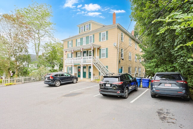

Property Detail
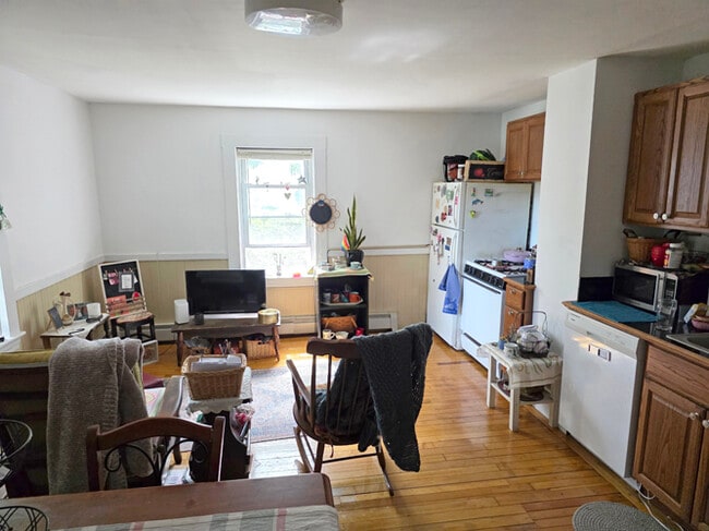
22 Waltham St
Apartment
Middlesex
B
Massachusetts
B and X Area of moderate flood hazard, usually the area between the limits of the 100-year and 500-year floods.
0.29 AC
2025
Maynard
2025
Boston
364102
Boston-Cambridge-Newton, MA-NH
7,812 SF
MAYN-000015-000000-000325
NEARBY LISTINGS FOR SALE OR LEASE
-
-
View all Maynard listings for sale on LoopNet.com
DEMOGRAPHICS near 22 Waltham St
1 mile
3 mile
5 mile
2025 Total Population
9,409
33,329
73,272
2030 Population
9,772
34,721
76,434
Pop Growth 2025-2030
+ 3.86%
+ 4.18%
+ 4.32%
Average Age
43
42
43
2025 Total Households
3,990
12,656
27,224
HH Growth 2025-2030
+ 3.83%
+ 4.28%
+ 4.47%
Median Household Inc
$114,731
$166,469
$188,084
Avg Household Size
2.30
2.60
2.60
2025 Avg HH Vehicles
2.00
2.00
2.00
Median Home Value
$561,917
$757,702
$814,407
Median Year Built
1961
1970
1972
Nearby Places
Map Layers
Map Styles
 Street
 Aerial
Transit
 Traffic
 Biking
Places
Listings with unknown addresses are not visible on the map
- Restaurants
- Banks
- Shops
- Fitness
- Groceries
PUBLIC TRANSPORTATION
COMMUTER RAIL
South Acton (Fitchburg/South Acton Line - Massachusetts Bay Transportation Authority Commuter Rail (Purple Line))
Drive
Walk
Distance
South Acton (Fitchburg/South Acton Line - Massachusetts Bay Transportation Authority Commuter Rail (Purple Line))
5 min
2.4 mi
West Concord (Fitchburg/South Acton Line - Massachusetts Bay Transportation Authority Commuter Rail (Purple Line))
Drive
Walk
Distance
West Concord (Fitchburg/South Acton Line - Massachusetts Bay Transportation Authority Commuter Rail (Purple Line))
7 min
3.6 mi
AIRPORT
General Edward Lawrence Logan International
Drive
Walk
Distance
General Edward Lawrence Logan International
44 min
27.0 mi
Worcester Regional
Drive
Walk
Distance
Worcester Regional
48 min
29.7 mi
Freight Ports
Port of Boston
Drive
Walk
Distance
Port of Boston
44 min
27.1 mi
SALE & LEASE HISTORY
LISTING DATE
SALE/LEASE

Sep 12, 2025
For Sale
Nearby Properties
Address
Land Use
TOTAL SIZE
Lot Size
Zoning
Address
Land Use
TOTAL SIZE
Lot Size
Zoning
30.39 AC
I
Address
Land Use
TOTAL SIZE
Lot Size
Zoning
160 SF
R1
Address
Land Use
TOTAL SIZE
Lot Size
Zoning
326,464 SF
19.52 AC
I
Address
Land Use
TOTAL SIZE
Lot Size
Zoning
77,323 SF
18 AC
C
Address
Land Use
TOTAL SIZE
Lot Size
Zoning
51,504 SF
18.87 AC
C
Address
Land Use
TOTAL SIZE
Lot Size
Zoning
31.29 AC
AA
Address
Land Use
TOTAL SIZE
Lot Size
Zoning
46.82 AC
RC
Address
Land Use
TOTAL SIZE
Lot Size
Zoning
7.88 AC
B
Address
Land Use
TOTAL SIZE
Lot Size
Zoning
155,339 SF
24 AC
R1
Address
Land Use
TOTAL SIZE
Lot Size
Zoning
35.99 AC
HI
Address
Land Use
TOTAL SIZE
Lot Size
Zoning
9.56 AC
PM
Address
Land Use
TOTAL SIZE
Lot Size
Zoning
815 AC
OS
Address
Land Use
TOTAL SIZE
Lot Size
Zoning
13.19 AC
B
Address
Land Use
TOTAL SIZE
Lot Size
Zoning
54,892 SF
7.99 AC
AA
Address
Land Use
TOTAL SIZE
Lot Size
Zoning
13.07 AC
RD
Address
Land Use
TOTAL SIZE
Lot Size
Zoning
4,621 SF
64.80 AC
RD
Address
Land Use
TOTAL SIZE
Lot Size
Zoning
990.40 AC
RC
Address
Land Use
TOTAL SIZE
Lot Size
Zoning
40 AC
R2
Address
Land Use
TOTAL SIZE
Lot Size
Zoning
33.05 AC
I
Address
Land Use
TOTAL SIZE
Lot Size
Zoning
26.16 AC
R2
Address
Land Use
TOTAL SIZE
Lot Size
Zoning
105,163 SF
10.65 AC
OP2
Address
Land Use
TOTAL SIZE
Lot Size
Zoning
85,000 SF
18.77 AC
R1
Address
Land Use
TOTAL SIZE
Lot Size
Zoning
98,750 SF
15.48 AC
OP2
Address
Land Use
TOTAL SIZE
Lot Size
Zoning
124,668 SF
9.89 AC
I
Address
Land Use
TOTAL SIZE
Lot Size
Zoning
5,002 SF
34.80 AC
PM
Address
Land Use
TOTAL SIZE
Lot Size
Zoning
6.73 AC
R2
Address
Land Use
TOTAL SIZE
Lot Size
Zoning
3.89 AC
C
Address
Land Use
TOTAL SIZE
Lot Size
Zoning
8.06 AC
R1
Address
Land Use
TOTAL SIZE
Lot Size
Zoning
64,998 SF
1.88 AC
KC
Address
Land Use
TOTAL SIZE
Lot Size
Zoning
18,564 SF
12 AC
R2
The World's #1 Commercial Real Estate Marketplace
Connect with us
© 2026 CoStar Group
The information above has been obtained from sources believed reliable. While we do not doubt its accuracy we have not verified it and make no guarantee, warranty or representation about it. It is your responsibility to independently confirm its accuracy and completeness. Any projections, opinions, assumptions, or estimates used are for example only and do not represent the current or future performance of the property. The value of this transaction to you depends on tax and other factors which should be evaluated by your tax, financial, and legal advisors. You and your advisors should conduct a careful, independent investigation of the property to determine to your satisfaction the suitability of the property for your needs.