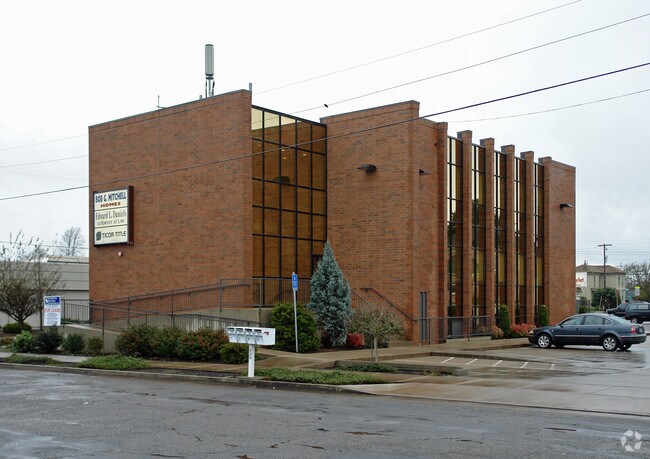
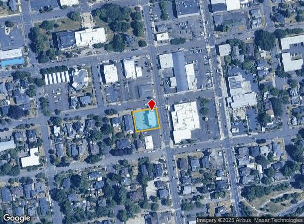
Property Record
220 6Th Ave Sw, Albany, OR 97321


NEARBY LISTINGS FOR SALE OR LEASE
Property Detail
220 6Th Ave Sw
0091989
Albany, Plan Of
Commercialnec
11S03W07BB
X
Linn
41003C0113G
Oregon
2025
0.34 AC
2025
Linn County
020400
Portland
10,854 SF
Albany, OR
DEMOGRAPHICS near 220 6Th Ave Sw
1 Mile
3 Mile
5 Mile
2024 Total Population
10,969
56,029
66,745
2029 Population
11,427
58,606
69,945
Pop Growth 2024-2029
+ 4.18%
+ 4.60%
+ 4.79%
Average Age
39
40
40
2024 Total Households
4,338
21,980
25,926
HH Growth 2024-2029
+ 4.29%
+ 4.75%
+ 4.94%
Median Household Inc
$54,225
$69,315
$72,959
Avg Household Size
2.40
2.50
2.50
2024 Avg HH Vehicles
2.00
2.00
2.00
Median Home Value
$300,348
$326,360
$338,984
Median Year Built
1958
1979
1981
Nearby Places
Map Layers
Map Styles
 Street
 Aerial
- Restaurants
- Banks
- Shops
- Fitness
- Groceries
PUBLIC TRANSPORTATION
COMMUTER RAIL
Albany Amtrak Station (Amtrak Cascades - Amtrak, Coast Starlight - Amtrak)
DRIVE
WALK
Distance
Albany Amtrak Station (Amtrak Cascades - Amtrak, Coast Starlight - Amtrak)
1 min
11 min
0.3 mi
Freight Ports
Port of Portland
DRIVE
WALK
Distance
Port of Portland
92 min
72.4 mi
SALE & LEASE HISTORY
LISTING DATE
SALE/LEASE

Sep 10, 2019
For Lease
Nov 19, 2018
For Lease
Nov 18, 2018
For Sale
Jun 03, 2019
For Lease
Jun 03, 2019
For Sale
Jan 17, 2022
For Lease
Nearby Properties
Address
Land Use
TOTAL SIZE
Lot Size
Zoning
Address
Land Use
TOTAL SIZE
Lot Size
Zoning
1.94 AC
Address
Land Use
TOTAL SIZE
Lot Size
Zoning
34.91 AC
LI
Address
Land Use
TOTAL SIZE
Lot Size
Zoning
41.22 AC
LI
Address
Land Use
TOTAL SIZE
Lot Size
Zoning
46.43 AC
GI
Address
Land Use
TOTAL SIZE
Lot Size
Zoning
18.57 AC
RC
Address
Land Use
TOTAL SIZE
Lot Size
Zoning
33,540 SF
2.19 AC
ES
Address
Land Use
TOTAL SIZE
Lot Size
Zoning
23,340 SF
10.60 AC
CC
Address
Land Use
TOTAL SIZE
Lot Size
Zoning
28.17 AC
HI
Address
Land Use
TOTAL SIZE
Lot Size
Zoning
58,202 SF
5.14 AC
RM
Address
Land Use
TOTAL SIZE
Lot Size
Zoning
20.04 AC
LI
Address
Land Use
TOTAL SIZE
Lot Size
Zoning
3.75 AC
OP
Address
Land Use
TOTAL SIZE
Lot Size
Zoning
13.01 AC
RC
Address
Land Use
TOTAL SIZE
Lot Size
Zoning
67,716 SF
6.90 AC
LI
Address
Land Use
TOTAL SIZE
Lot Size
Zoning
46.46 AC
GI
Address
Land Use
TOTAL SIZE
Lot Size
Zoning
43.06 AC
RS-6.5
Address
Land Use
TOTAL SIZE
Lot Size
Zoning
84,000 SF
8.99 AC
RC
Address
Land Use
TOTAL SIZE
Lot Size
Zoning
50,648 SF
8.35 AC
RS-6.5
Address
Land Use
TOTAL SIZE
Lot Size
Zoning
45,543 SF
24.28 AC
LI
Address
Land Use
TOTAL SIZE
Lot Size
Zoning
11.01 AC
CC
Address
Land Use
TOTAL SIZE
Lot Size
Zoning
666 SF
6.32 AC
RM
Address
Land Use
TOTAL SIZE
Lot Size
Zoning
11,296 SF
1.36 AC
HM
Address
Land Use
TOTAL SIZE
Lot Size
Zoning
3,591 SF
2.15 AC
RM
Address
Land Use
TOTAL SIZE
Lot Size
Zoning
151,290 SF
5.45 AC
RM
Address
Land Use
TOTAL SIZE
Lot Size
Zoning
194,166 SF
10.14 AC
RS-10
Address
Land Use
TOTAL SIZE
Lot Size
Zoning
19,950 SF
11.11 AC
RC
Address
Land Use
TOTAL SIZE
Lot Size
Zoning
5.27 AC
MUC
Address
Land Use
TOTAL SIZE
Lot Size
Zoning
52,626 SF
5.40 AC
RS-6.5
Address
Land Use
TOTAL SIZE
Lot Size
Zoning
Address
Land Use
TOTAL SIZE
Lot Size
Zoning
1,795 SF
8.98 AC
RC
Address
Land Use
TOTAL SIZE
Lot Size
Zoning
31,192 SF
8.20 AC
RMA
The World's #1 Commercial Real Estate Marketplace
Connect with us
© 2026 CoStar Group
The information above has been obtained from sources believed reliable. While we do not doubt its accuracy we have not verified it and make no guarantee, warranty or representation about it. It is your responsibility to independently confirm its accuracy and completeness. Any projections, opinions, assumptions, or estimates used are for example only and do not represent the current or future performance of the property. The value of this transaction to you depends on tax and other factors which should be evaluated by your tax, financial, and legal advisors. You and your advisors should conduct a careful, independent investigation of the property to determine to your satisfaction the suitability of the property for your needs.