Property Record
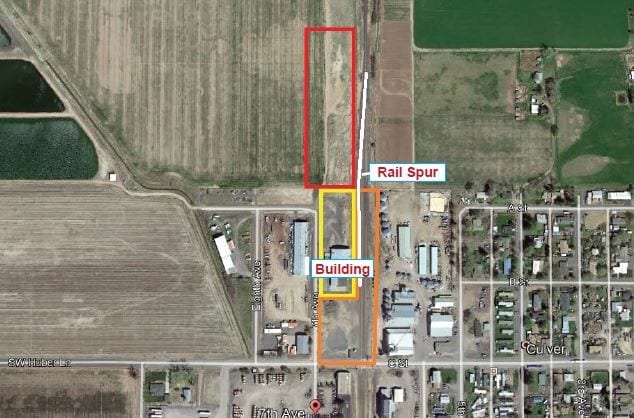
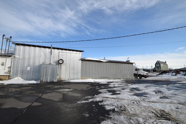
220 7Th Ave, Culver, OR 97734

Property Detail
220 7Th Ave
121318-DB-02103
SEC 18 NWSE / 12 S 13 E 18 DB 02103 00
Commercialnec
Jefferson
M1
Oregon
2025
1.65 AC
2025
Jefferson County
960304
Other Market Areas
12,876 SF
Bend, OR
NEARBY LISTINGS FOR SALE OR LEASE
-
-
View all Culver listings for sale on LoopNet.com
DEMOGRAPHICS near 220 7Th Ave
1 mile
3 mile
5 mile
2025 Total Population
1,499
2,603
4,000
2030 Population
1,482
2,591
4,025
Pop Growth 2025-2030
(1.13%)
(0.46%)
+ 0.63%
Average Age
37
39
40
2025 Total Households
499
813
1,265
HH Growth 2025-2030
(1.60%)
(1.23%)
+ 0.24%
Median Household Inc
$85,019
$84,801
$80,386
Avg Household Size
3.00
2.90
2.90
2025 Avg HH Vehicles
3.00
3.00
3.00
Median Home Value
$340,511
$354,521
$343,061
Median Year Built
1987
1984
1988
Nearby Places
Map Layers
Map Styles
 Street
 Aerial
Layers
 Traffic
 Biking
Places
Listings with unknown addresses are not visible on the map
- Restaurants
- Banks
- Shops
- Fitness
- Groceries
PUBLIC TRANSPORTATION
AIRPORT
Roberts Field
Drive
Walk
Distance
Roberts Field
33 min
20.9 mi
SALE & LEASE HISTORY
LISTING DATE
SALE/LEASE

Dec 16, 2020
For Sale
Dec 02, 2019
For Sale
Nearby Properties
Address
Land Use
TOTAL SIZE
Lot Size
Zoning
Address
Land Use
TOTAL SIZE
Lot Size
Zoning
113,581 SF
13.90 AC
OS
Address
Land Use
TOTAL SIZE
Lot Size
Zoning
19,740 SF
0.68 AC
R2
Address
Land Use
TOTAL SIZE
Lot Size
Zoning
10,436 SF
0.79 AC
C1
Address
Land Use
TOTAL SIZE
Lot Size
Zoning
10 SF
3.96 AC
M1
Address
Land Use
TOTAL SIZE
Lot Size
Zoning
8,481 SF
41.06 AC
A-1
Address
Land Use
TOTAL SIZE
Lot Size
Zoning
7,778 SF
237.40 AC
A-1
Address
Land Use
TOTAL SIZE
Lot Size
Zoning
31,800 SF
5.09 AC
M1
Address
Land Use
TOTAL SIZE
Lot Size
Zoning
1,652 SF
4.70 AC
A-1
Address
Land Use
TOTAL SIZE
Lot Size
Zoning
3,598 SF
Address
Land Use
TOTAL SIZE
Lot Size
Zoning
9,120 SF
1.31 AC
C1
Address
Land Use
TOTAL SIZE
Lot Size
Zoning
528 SF
0.34 AC
R2
Address
Land Use
TOTAL SIZE
Lot Size
Zoning
1,431 SF
194.70 AC
PM
Address
Land Use
TOTAL SIZE
Lot Size
Zoning
2,444 SF
39.40 AC
A-1
Address
Land Use
TOTAL SIZE
Lot Size
Zoning
3,936 SF
155.91 AC
A-1
Address
Land Use
TOTAL SIZE
Lot Size
Zoning
1.52 AC
R2
Address
Land Use
TOTAL SIZE
Lot Size
Zoning
5,871 SF
79.40 AC
A-1
Address
Land Use
TOTAL SIZE
Lot Size
Zoning
1,680 SF
3.40 AC
A-1
Address
Land Use
TOTAL SIZE
Lot Size
Zoning
2,121 SF
2.23 AC
RR-5
Address
Land Use
TOTAL SIZE
Lot Size
Zoning
1,056 SF
2.38 AC
OS
Address
Land Use
TOTAL SIZE
Lot Size
Zoning
4,081 SF
40.38 AC
A-1
Address
Land Use
TOTAL SIZE
Lot Size
Zoning
3,758 SF
155.82 AC
A-1
Address
Land Use
TOTAL SIZE
Lot Size
Zoning
7,200 SF
1.38 AC
M1
Address
Land Use
TOTAL SIZE
Lot Size
Zoning
2,954 SF
70.50 AC
A-1
Address
Land Use
TOTAL SIZE
Lot Size
Zoning
4,400 SF
115.60 AC
A-1
Address
Land Use
TOTAL SIZE
Lot Size
Zoning
8,076 SF
0.13 AC
C1
Address
Land Use
TOTAL SIZE
Lot Size
Zoning
1,390 SF
0.23 AC
R2
Address
Land Use
TOTAL SIZE
Lot Size
Zoning
2,922 SF
39.50 AC
A-1
Address
Land Use
TOTAL SIZE
Lot Size
Zoning
1,008 SF
14.97 AC
R1
The World's #1 Commercial Real Estate Marketplace
Connect with us
© 2026 CoStar Group
The information above has been obtained from sources believed reliable. While we do not doubt its accuracy we have not verified it and make no guarantee, warranty or representation about it. It is your responsibility to independently confirm its accuracy and completeness. Any projections, opinions, assumptions, or estimates used are for example only and do not represent the current or future performance of the property. The value of this transaction to you depends on tax and other factors which should be evaluated by your tax, financial, and legal advisors. You and your advisors should conduct a careful, independent investigation of the property to determine to your satisfaction the suitability of the property for your needs.