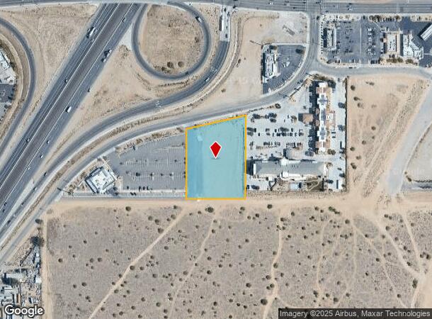
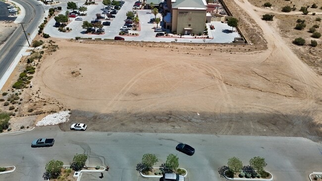
Property Record
Mariposa Rd, Hesperia, CA 92345

This Property Is For Sale
Current Lease Availabilities
NEARBY LISTINGS FOR SALE OR LEASE
Property Detail
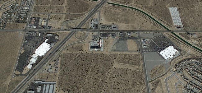
Mariposa Rd
Riverside-San Bernardino-Ontario, CA
Parcel Map 19686
3057-011-51
PARCEL MAP 19686 PARCEL 2 BOOK 246 PAGE 35
Vacantlandnec
San Bernardino
X
California
06071C6475H
2.15 AC
2024
Mojave River Valley
2025
Inland Empire (California)
010019
DEMOGRAPHICS near Mariposa Rd
1 Mile
3 Mile
5 Mile
2024 Total Population
5,242
38,250
121,731
2029 Population
5,371
39,310
124,361
Pop Growth 2024-2029
+ 2.46%
+ 2.77%
+ 2.16%
Average Age
34
35
35
2024 Total Households
1,471
10,615
34,169
HH Growth 2024-2029
+ 2.58%
+ 2.84%
+ 2.15%
Median Household Inc
$92,804
$83,839
$70,736
Avg Household Size
3.60
3.50
3.50
2024 Avg HH Vehicles
2.00
3.00
2.00
Median Home Value
$381,355
$357,161
$354,495
Median Year Built
2005
2000
1994
Nearby Places
- Restaurants
- Banks
- Shops
- Fitness
- Groceries
PUBLIC TRANSPORTATION
AIRPORT
Ontario International
DRIVE
WALK
Distance
Ontario International
44 min
37.1 mi
Freight Ports
Port of Long Beach
DRIVE
WALK
Distance
Port of Long Beach
106 min
89.2 mi
Nearby Properties
Address
Land Use
TOTAL SIZE
Lot Size
Zoning
Address
Land Use
TOTAL SIZE
Lot Size
Zoning
1,226,588 SF
54.88 AC
Address
Land Use
TOTAL SIZE
Lot Size
Zoning
1,055,350 SF
59.71 AC
Address
Land Use
TOTAL SIZE
Lot Size
Zoning
1,003,485 SF
54.80 AC
Address
Land Use
TOTAL SIZE
Lot Size
Zoning
315,603 SF
48.21 AC
Address
Land Use
TOTAL SIZE
Lot Size
Zoning
62.93 AC
Address
Land Use
TOTAL SIZE
Lot Size
Zoning
54,994 SF
9.12 AC
Address
Land Use
TOTAL SIZE
Lot Size
Zoning
38.91 AC
Address
Land Use
TOTAL SIZE
Lot Size
Zoning
37.37 AC
Address
Land Use
TOTAL SIZE
Lot Size
Zoning
38.45 AC
Address
Land Use
TOTAL SIZE
Lot Size
Zoning
616,817 SF
31.82 AC
Address
Land Use
TOTAL SIZE
Lot Size
Zoning
171,830 SF
9.01 AC
Address
Land Use
TOTAL SIZE
Lot Size
Zoning
194,712 SF
20.24 AC
Address
Land Use
TOTAL SIZE
Lot Size
Zoning
177,833 SF
14.29 AC
Address
Land Use
TOTAL SIZE
Lot Size
Zoning
10.31 AC
Address
Land Use
TOTAL SIZE
Lot Size
Zoning
86.34 AC
Address
Land Use
TOTAL SIZE
Lot Size
Zoning
79,477 SF
4.70 AC
Address
Land Use
TOTAL SIZE
Lot Size
Zoning
80,080 SF
4.88 AC
Address
Land Use
TOTAL SIZE
Lot Size
Zoning
52,612 SF
2 AC
Address
Land Use
TOTAL SIZE
Lot Size
Zoning
83,102 SF
2.94 AC
Address
Land Use
TOTAL SIZE
Lot Size
Zoning
150,000 SF
12.53 AC
Address
Land Use
TOTAL SIZE
Lot Size
Zoning
79,477 SF
4.33 AC
Address
Land Use
TOTAL SIZE
Lot Size
Zoning
127,502 SF
9.32 AC
Address
Land Use
TOTAL SIZE
Lot Size
Zoning
28.68 AC
Address
Land Use
TOTAL SIZE
Lot Size
Zoning
14,228 SF
1.53 AC
Address
Land Use
TOTAL SIZE
Lot Size
Zoning
44,532 SF
1.93 AC
Address
Land Use
TOTAL SIZE
Lot Size
Zoning
152,482 SF
14.72 AC
R3
Address
Land Use
TOTAL SIZE
Lot Size
Zoning
29,988 SF
3.21 AC
Address
Land Use
TOTAL SIZE
Lot Size
Zoning
51,021 SF
4.30 AC
Address
Land Use
TOTAL SIZE
Lot Size
Zoning
41,640 SF
4.06 AC
Address
Land Use
TOTAL SIZE
Lot Size
Zoning
10,923 SF
17.01 AC
The World's #1 Commercial Real Estate Marketplace
Connect with us
© 2025 CoStar Group
The information above has been obtained from sources believed reliable. While we do not doubt its accuracy we have not verified it and make no guarantee, warranty or representation about it. It is your responsibility to independently confirm its accuracy and completeness. Any projections, opinions, assumptions, or estimates used are for example only and do not represent the current or future performance of the property. The value of this transaction to you depends on tax and other factors which should be evaluated by your tax, financial, and legal advisors. You and your advisors should conduct a careful, independent investigation of the property to determine to your satisfaction the suitability of the property for your needs.