Property Record
220 Carpenter St, Greenport, NY 11944
NEARBY LISTINGS FOR SALE OR LEASE
-
-
View all Greenport listings for sale on LoopNet.com
Property Detail
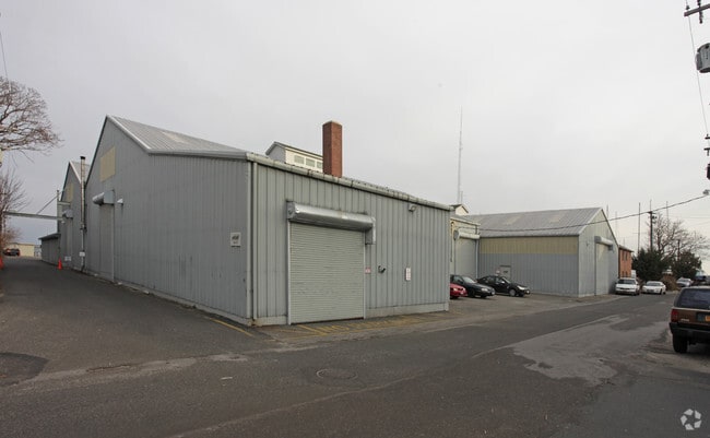
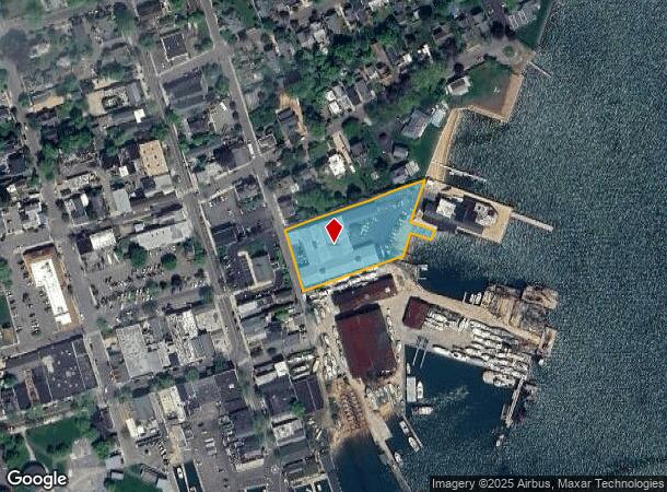
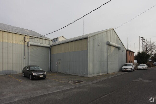
220 Carpenter St
Nassau County-Suffolk County, NY
BOOK 11344 PAGE 470 BILL 000725
1001-005-00-03-00-008-000
Suffolk
Portharbor
New York
VE
8
36103C0176H
1.39 AC
2024
Eastern Suffolk
2024
Long Island (New York)
170101
DEMOGRAPHICS near 220 Carpenter St
1 Mile
3 Mile
5 Mile
2024 Total Population
4,746
10,569
16,189
2029 Population
4,893
10,905
16,620
Pop Growth 2024-2029
+ 3.10%
+ 3.18%
+ 2.66%
Average Age
44
48
49
2024 Total Households
1,855
4,583
7,026
HH Growth 2024-2029
+ 3.18%
+ 3.25%
+ 2.66%
Median Household Inc
$67,085
$84,091
$88,982
Avg Household Size
2.40
2.20
2.20
2024 Avg HH Vehicles
2.00
2.00
2.00
Median Home Value
$727,973
$769,851
$764,994
Median Year Built
1953
1970
1972
Nearby Places
- Restaurants
- Banks
- Shops
- Fitness
- Groceries
PUBLIC TRANSPORTATION
COMMUTER RAIL
Greenport Station (Greenport Branch - Long Island Rail Road)
DRIVE
WALK
Distance
Greenport Station (Greenport Branch - Long Island Rail Road)
2 min
8 min
0.5 mi
Southold Station (Greenport Branch - Long Island Rail Road)
DRIVE
WALK
Distance
Southold Station (Greenport Branch - Long Island Rail Road)
10 min
4.9 mi
Freight Ports
Port of New Haven
DRIVE
WALK
Distance
Port of New Haven
166 min
72.8 mi
Nearby Properties
Address
Land Use
TOTAL SIZE
Lot Size
Zoning
Address
Land Use
TOTAL SIZE
Lot Size
Zoning
600 AC
AA
Address
Land Use
TOTAL SIZE
Lot Size
Zoning
16,757 SF
319.50 AC
AA
Address
Land Use
TOTAL SIZE
Lot Size
Zoning
8,705 SF
138.70 AC
AA
Address
Land Use
TOTAL SIZE
Lot Size
Zoning
77,580 SF
8.33 AC
C
Address
Land Use
TOTAL SIZE
Lot Size
Zoning
5,695 SF
139.50 AC
AA
Address
Land Use
TOTAL SIZE
Lot Size
Zoning
33,799 SF
7.53 AC
AA
Address
Land Use
TOTAL SIZE
Lot Size
Zoning
9,468 SF
3.20 AC
AA
Address
Land Use
TOTAL SIZE
Lot Size
Zoning
170 AC
AA
Address
Land Use
TOTAL SIZE
Lot Size
Zoning
21,700 SF
7.90 AC
C
Address
Land Use
TOTAL SIZE
Lot Size
Zoning
23,354 SF
0.64 AC
AA
Address
Land Use
TOTAL SIZE
Lot Size
Zoning
1,396 SF
6.45 AC
AA
Address
Land Use
TOTAL SIZE
Lot Size
Zoning
8.70 AC
AA
Address
Land Use
TOTAL SIZE
Lot Size
Zoning
864 SF
3.20 AC
B
Address
Land Use
TOTAL SIZE
Lot Size
Zoning
2,076 SF
42.20 AC
AA
Address
Land Use
TOTAL SIZE
Lot Size
Zoning
7,938 SF
0.58 AC
A
Address
Land Use
TOTAL SIZE
Lot Size
Zoning
319.50 AC
AA
Address
Land Use
TOTAL SIZE
Lot Size
Zoning
8.31 AC
C
Address
Land Use
TOTAL SIZE
Lot Size
Zoning
904 SF
20.30 AC
AA
Address
Land Use
TOTAL SIZE
Lot Size
Zoning
63.60 AC
C
Address
Land Use
TOTAL SIZE
Lot Size
Zoning
8,793 SF
1.29 AC
B1
Address
Land Use
TOTAL SIZE
Lot Size
Zoning
251.50 AC
AA
Address
Land Use
TOTAL SIZE
Lot Size
Zoning
12,000 SF
5.39 AC
B
Address
Land Use
TOTAL SIZE
Lot Size
Zoning
2,925 SF
1.40 AC
B
Address
Land Use
TOTAL SIZE
Lot Size
Zoning
4,340 SF
0.88 AC
AA
Address
Land Use
TOTAL SIZE
Lot Size
Zoning
16.84 AC
C
Address
Land Use
TOTAL SIZE
Lot Size
Zoning
14.25 AC
A
Address
Land Use
TOTAL SIZE
Lot Size
Zoning
0.44 AC
AA
Address
Land Use
TOTAL SIZE
Lot Size
Zoning
2.20 AC
AA
Address
Land Use
TOTAL SIZE
Lot Size
Zoning
1,284 SF
11.38 AC
C
Address
Land Use
TOTAL SIZE
Lot Size
Zoning
11.10 AC
A
The World's #1 Commercial Real Estate Marketplace
Connect with us
© 2025 CoStar Group
The information above has been obtained from sources believed reliable. While we do not doubt its accuracy we have not verified it and make no guarantee, warranty or representation about it. It is your responsibility to independently confirm its accuracy and completeness. Any projections, opinions, assumptions, or estimates used are for example only and do not represent the current or future performance of the property. The value of this transaction to you depends on tax and other factors which should be evaluated by your tax, financial, and legal advisors. You and your advisors should conduct a careful, independent investigation of the property to determine to your satisfaction the suitability of the property for your needs.