Property Record
220 Commissioners Rd, Harrison, NJ 07029
NEARBY LISTINGS FOR SALE OR LEASE
-
-
View all Harrison listings for sale on LoopNet.com
Property Detail
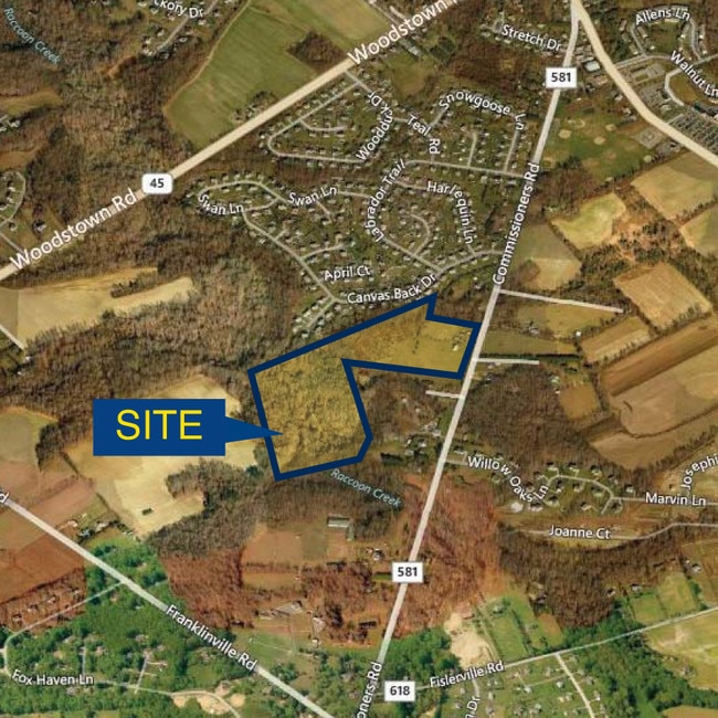
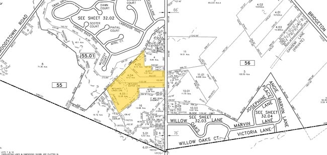
220 Commissioners Rd
Philadelphia
ADDITIONAL LOTS: HARMAN ESTATES DEVEL
Philadelphia-Camden-Wilmington, PA-NJ-DE-MD
Gloucester
08-00055-0000-00004-04-QFARM
New Jersey
Farms
4.5
2024
1 AC
2025
Gloucester County
013600
DEMOGRAPHICS near 220 Commissioners Rd
1 Mile
3 Mile
5 Mile
2024 Total Population
2,333
15,219
34,745
2029 Population
2,395
15,624
35,730
Pop Growth 2024-2029
+ 2.66%
+ 2.66%
+ 2.83%
Average Age
39
40
40
2024 Total Households
747
5,048
11,847
HH Growth 2024-2029
+ 2.68%
+ 2.69%
+ 2.84%
Median Household Inc
$157,269
$147,334
$130,454
Avg Household Size
3.10
3.00
2.90
2024 Avg HH Vehicles
3.00
2.00
2.00
Median Home Value
$483,673
$448,286
$392,507
Median Year Built
1998
1994
1994
Nearby Places
Map Layers
Map Styles
 Street
 Aerial
- Restaurants
- Banks
- Shops
- Fitness
- Groceries
PUBLIC TRANSPORTATION
AIRPORT
Philadelphia International
DRIVE
WALK
Distance
Philadelphia International
39 min
23.3 mi
Freight Ports
Broadway Terminal - Pier 5
DRIVE
WALK
Distance
Broadway Terminal - Pier 5
28 min
17.8 mi
Nearby Properties
Address
Land Use
TOTAL SIZE
Lot Size
Zoning
Address
Land Use
TOTAL SIZE
Lot Size
Zoning
80.26 AC
INS
Address
Land Use
TOTAL SIZE
Lot Size
Zoning
13.76 AC
INS
Address
Land Use
TOTAL SIZE
Lot Size
Zoning
573.50 AC
AR
Address
Land Use
TOTAL SIZE
Lot Size
Zoning
24.79 AC
R1
Address
Land Use
TOTAL SIZE
Lot Size
Zoning
5,893 SF
12.79 AC
INSH
Address
Land Use
TOTAL SIZE
Lot Size
Zoning
7.85 AC
R12
Address
Land Use
TOTAL SIZE
Lot Size
Zoning
12.45 AC
AR
Address
Land Use
TOTAL SIZE
Lot Size
Zoning
13.20 AC
INS
Address
Land Use
TOTAL SIZE
Lot Size
Zoning
5.15 AC
C1
Address
Land Use
TOTAL SIZE
Lot Size
Zoning
3.90 AC
INS
Address
Land Use
TOTAL SIZE
Lot Size
Zoning
19.15 AC
INS
Address
Land Use
TOTAL SIZE
Lot Size
Zoning
23.26 AC
LI
Address
Land Use
TOTAL SIZE
Lot Size
Zoning
Address
Land Use
TOTAL SIZE
Lot Size
Zoning
8 AC
C2
Address
Land Use
TOTAL SIZE
Lot Size
Zoning
4.73 AC
R1
Address
Land Use
TOTAL SIZE
Lot Size
Zoning
5.41 AC
LI
Address
Land Use
TOTAL SIZE
Lot Size
Zoning
2,984 SF
5.27 AC
R1
Address
Land Use
TOTAL SIZE
Lot Size
Zoning
9.59 AC
INS
Address
Land Use
TOTAL SIZE
Lot Size
Zoning
5.39 AC
C2
Address
Land Use
TOTAL SIZE
Lot Size
Zoning
6.66 AC
LI
Address
Land Use
TOTAL SIZE
Lot Size
Zoning
0.57 AC
C2
Address
Land Use
TOTAL SIZE
Lot Size
Zoning
3.70 AC
LI
Address
Land Use
TOTAL SIZE
Lot Size
Zoning
3.34 AC
LI
Address
Land Use
TOTAL SIZE
Lot Size
Zoning
15.76 AC
LI
Address
Land Use
TOTAL SIZE
Lot Size
Zoning
10,112 SF
1.13 AC
C2
Address
Land Use
TOTAL SIZE
Lot Size
Zoning
12,040 SF
3.01 AC
Address
Land Use
TOTAL SIZE
Lot Size
Zoning
10,617 SF
17.22 AC
R1
Address
Land Use
TOTAL SIZE
Lot Size
Zoning
9,552 SF
1.40 AC
INS
Address
Land Use
TOTAL SIZE
Lot Size
Zoning
2,012 SF
6.20 AC
INS
Address
Land Use
TOTAL SIZE
Lot Size
Zoning
2,752 SF
3.30 AC
C-1
The World's #1 Commercial Real Estate Marketplace
Connect with us
© 2025 CoStar Group
The information above has been obtained from sources believed reliable. While we do not doubt its accuracy we have not verified it and make no guarantee, warranty or representation about it. It is your responsibility to independently confirm its accuracy and completeness. Any projections, opinions, assumptions, or estimates used are for example only and do not represent the current or future performance of the property. The value of this transaction to you depends on tax and other factors which should be evaluated by your tax, financial, and legal advisors. You and your advisors should conduct a careful, independent investigation of the property to determine to your satisfaction the suitability of the property for your needs.