Property Record
220 Complex Dr, Lakeland, FL 33801

NEARBY LISTINGS FOR SALE OR LEASE
Property Detail
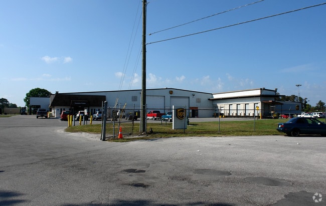
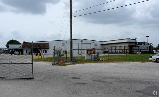
220 Complex Dr
24-28-15-179010-000210
Main Street Industrial Complex
Warehouse
MAIN STREET INDUSTRIAL COMPLEX PB 73 PG 24 TRACT A & A UNDIVIDED INTEREST IN COMPLEX DRIVE EASEMENT & BEG 332.88 FT E OF SW COR OF SEC RUN E 665.78 FT N 615.07 FT W 665.97 S 615.74 FT TO POB
AE
Polk
12105C0320G
Florida
2024
14.36 AC
2025
Polk County
011704
Tampa/St Petersburg
51,059 SF
Lakeland-Winter Haven, FL
DEMOGRAPHICS near 220 Complex Dr
1 Mile
3 Mile
5 Mile
2024 Total Population
6,518
46,973
115,208
2029 Population
7,790
55,719
137,379
Pop Growth 2024-2029
+ 19.52%
+ 18.62%
+ 19.24%
Average Age
35
37
40
2024 Total Households
2,204
17,025
45,180
HH Growth 2024-2029
+ 19.51%
+ 19.52%
+ 19.60%
Median Household Inc
$40,396
$43,961
$47,977
Avg Household Size
2.50
2.30
2.30
2024 Avg HH Vehicles
2.00
2.00
2.00
Median Home Value
$111,862
$136,099
$153,790
Median Year Built
1975
1975
1977
Nearby Places
Map Layers
Map Styles
 Street
 Aerial
- Restaurants
- Banks
- Shops
- Fitness
- Groceries
PUBLIC TRANSPORTATION
COMMUTER RAIL
Lakeland (Silver Star - Amtrak)
DRIVE
WALK
Distance
Lakeland (Silver Star - Amtrak)
6 min
3.2 mi
Freight Ports
Port of Tampa Bay
DRIVE
WALK
Distance
Port of Tampa Bay
52 min
37.5 mi
Nearby Properties
Address
Land Use
TOTAL SIZE
Lot Size
Zoning
Address
Land Use
TOTAL SIZE
Lot Size
Zoning
414,112 SF
13.60 AC
MF22
Address
Land Use
TOTAL SIZE
Lot Size
Zoning
417,661 SF
39.48 AC
Address
Land Use
TOTAL SIZE
Lot Size
Zoning
718,026 SF
49.37 AC
RE2
Address
Land Use
TOTAL SIZE
Lot Size
Zoning
24,871 SF
54.24 AC
RB1
Address
Land Use
TOTAL SIZE
Lot Size
Zoning
394,631 SF
32.27 AC
XX
Address
Land Use
TOTAL SIZE
Lot Size
Zoning
282,596 SF
27.51 AC
RA3
Address
Land Use
TOTAL SIZE
Lot Size
Zoning
132,716 SF
20.62 AC
Address
Land Use
TOTAL SIZE
Lot Size
Zoning
155,735 SF
24.24 AC
XX
Address
Land Use
TOTAL SIZE
Lot Size
Zoning
103,446 SF
2.12 AC
RB1
Address
Land Use
TOTAL SIZE
Lot Size
Zoning
135,189 SF
2.57 AC
RB1
Address
Land Use
TOTAL SIZE
Lot Size
Zoning
96,412 SF
11.03 AC
I1
Address
Land Use
TOTAL SIZE
Lot Size
Zoning
286,120 SF
2.49 AC
C6
Address
Land Use
TOTAL SIZE
Lot Size
Zoning
175,230 SF
7.23 AC
MF22
Address
Land Use
TOTAL SIZE
Lot Size
Zoning
109,883 SF
12.40 AC
C4
Address
Land Use
TOTAL SIZE
Lot Size
Zoning
130,375 SF
14.51 AC
Address
Land Use
TOTAL SIZE
Lot Size
Zoning
218,911 SF
39.21 AC
Address
Land Use
TOTAL SIZE
Lot Size
Zoning
316,800 SF
9.47 AC
Address
Land Use
TOTAL SIZE
Lot Size
Zoning
206,796 SF
14.28 AC
I1
Address
Land Use
TOTAL SIZE
Lot Size
Zoning
152,129 SF
19.35 AC
MF12
Address
Land Use
TOTAL SIZE
Lot Size
Zoning
325,851 SF
21.97 AC
C4
Address
Land Use
TOTAL SIZE
Lot Size
Zoning
154,016 SF
7.24 AC
PUD
Address
Land Use
TOTAL SIZE
Lot Size
Zoning
55,772 SF
0.87 AC
MF22
Address
Land Use
TOTAL SIZE
Lot Size
Zoning
259,200 SF
8.17 AC
Address
Land Use
TOTAL SIZE
Lot Size
Zoning
108,000 SF
2.14 AC
PUD
Address
Land Use
TOTAL SIZE
Lot Size
Zoning
82,416 SF
0.88 AC
Address
Land Use
TOTAL SIZE
Lot Size
Zoning
48,617 SF
1.08 AC
C2
Address
Land Use
TOTAL SIZE
Lot Size
Zoning
67,668 SF
3.38 AC
MF22
Address
Land Use
TOTAL SIZE
Lot Size
Zoning
76,643 SF
34.20 AC
R3
Address
Land Use
TOTAL SIZE
Lot Size
Zoning
75,958 SF
11.28 AC
RA3
Address
Land Use
TOTAL SIZE
Lot Size
Zoning
71,967 SF
12.35 AC
RA3
The World's #1 Commercial Real Estate Marketplace
Connect with us
© 2025 CoStar Group
The information above has been obtained from sources believed reliable. While we do not doubt its accuracy we have not verified it and make no guarantee, warranty or representation about it. It is your responsibility to independently confirm its accuracy and completeness. Any projections, opinions, assumptions, or estimates used are for example only and do not represent the current or future performance of the property. The value of this transaction to you depends on tax and other factors which should be evaluated by your tax, financial, and legal advisors. You and your advisors should conduct a careful, independent investigation of the property to determine to your satisfaction the suitability of the property for your needs.