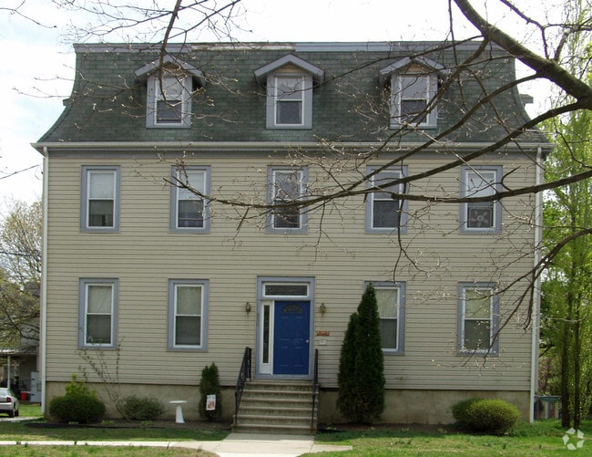
Property Record
220 E 4Th St, Palmyra, NJ 08065

Save to a Folder
{{folder.Name}}
{{folder.ListingIds.length}} Properties
{{folder.ListingIds.length}} Property
Create a New Folder
Property Detail
220 E 4Th St
Philadelphia-Camden-Wilmington, PA-NJ-DE-MD
Burlington
27-00089-0000-00001
New Jersey
Apartment
1
AE The base floodplain where base flood elevations are provided. AE Zones are now used on new format FIRMs instead of A1-A30 Zones.
0.17 AC
2025
Burlington County
2026
Philadelphia
700104
NEARBY LISTINGS FOR SALE OR LEASE
DEMOGRAPHICS near 220 E 4Th St
1 mile
3 mile
5 mile
2025 Total Population
11,473
131,062
465,873
2030 Population
11,715
128,970
459,866
Pop Growth 2025-2030
+ 2.11%
(1.60%)
(1.29%)
Average Age
43
38
39
2025 Total Households
4,737
47,851
170,863
HH Growth 2025-2030
+ 2.01%
(1.52%)
(1.31%)
Median Household Inc
$94,266
$67,732
$65,284
Avg Household Size
2.40
2.70
2.60
2025 Avg HH Vehicles
2.00
2.00
1.00
Median Home Value
$266,760
$234,449
$245,255
Median Year Built
1951
1953
1955
Nearby Places
Map Layers
Map Styles
 Street
 Aerial
Layers
 Traffic
 Biking
Places
Listings with unknown addresses are not visible on the map
- Restaurants
- Banks
- Shops
- Fitness
- Groceries
PUBLIC TRANSPORTATION
TRANSIT/SUBWAY
Palmyra (River LINE - River LINE (River LINE))
Drive
Walk
Distance
Palmyra (River LINE - River LINE (River LINE))
2 min
8 min
0.4 mi
Riverton (River LINE - River LINE (River LINE))
Drive
Walk
Distance
Riverton (River LINE - River LINE (River LINE))
1 min
11 min
0.5 mi
COMMUTER RAIL
Tacony (R7 - Southeastern Pennsylvania Transportation Authority Regional Rail (SEPTA Regional Rail))
Drive
Walk
Distance
Tacony (R7 - Southeastern Pennsylvania Transportation Authority Regional Rail (SEPTA Regional Rail))
7 min
2.6 mi
Bridesburg (R7 - Southeastern Pennsylvania Transportation Authority Regional Rail (SEPTA Regional Rail))
Drive
Walk
Distance
Bridesburg (R7 - Southeastern Pennsylvania Transportation Authority Regional Rail (SEPTA Regional Rail))
9 min
3.6 mi
AIRPORT
Philadelphia International
Drive
Walk
Distance
Philadelphia International
35 min
20.3 mi
Trenton Mercer
Drive
Walk
Distance
Trenton Mercer
43 min
27.4 mi
Freight Ports
Port of Philadelphia
Drive
Walk
Distance
Port of Philadelphia
15 min
6.9 mi
Nearby Properties
Address
Land Use
TOTAL SIZE
Lot Size
Zoning
Address
Land Use
TOTAL SIZE
Lot Size
Zoning
348,210 SF
51.22 AC
I3
Address
Land Use
TOTAL SIZE
Lot Size
Zoning
740,701 SF
47.70 AC
I2
Address
Land Use
TOTAL SIZE
Lot Size
Zoning
95,280 SF
117.33 AC
I3
Address
Land Use
TOTAL SIZE
Lot Size
Zoning
54.54 AC
Address
Land Use
TOTAL SIZE
Lot Size
Zoning
180,000 SF
23.05 AC
RSA1
Address
Land Use
TOTAL SIZE
Lot Size
Zoning
37.21 AC
SPPOA
Address
Land Use
TOTAL SIZE
Lot Size
Zoning
Address
Land Use
TOTAL SIZE
Lot Size
Zoning
50.73 AC
C73A
Address
Land Use
TOTAL SIZE
Lot Size
Zoning
470,871 SF
41.87 AC
I3
Address
Land Use
TOTAL SIZE
Lot Size
Zoning
410,400 SF
34.14 AC
RSA1
Address
Land Use
TOTAL SIZE
Lot Size
Zoning
95.79 AC
Address
Land Use
TOTAL SIZE
Lot Size
Zoning
227,844 SF
19.82 AC
I2
Address
Land Use
TOTAL SIZE
Lot Size
Zoning
251,791 SF
15.59 AC
I2
Address
Land Use
TOTAL SIZE
Lot Size
Zoning
228,652 SF
12.81 AC
I1
Address
Land Use
TOTAL SIZE
Lot Size
Zoning
437,192 SF
28.03 AC
I2
Address
Land Use
TOTAL SIZE
Lot Size
Zoning
27.33 AC
Address
Land Use
TOTAL SIZE
Lot Size
Zoning
179,848 SF
12.87 AC
RSA1
Address
Land Use
TOTAL SIZE
Lot Size
Zoning
169,768 SF
12.80 AC
Address
Land Use
TOTAL SIZE
Lot Size
Zoning
82.32 AC
Address
Land Use
TOTAL SIZE
Lot Size
Zoning
1,681 SF
3 AC
ICMX
Address
Land Use
TOTAL SIZE
Lot Size
Zoning
3.59 AC
Address
Land Use
TOTAL SIZE
Lot Size
Zoning
39.53 AC
Address
Land Use
TOTAL SIZE
Lot Size
Zoning
148,609 SF
8.84 AC
ICMX
Address
Land Use
TOTAL SIZE
Lot Size
Zoning
150.59 AC
Address
Land Use
TOTAL SIZE
Lot Size
Zoning
109,445 SF
12.70 AC
ICMX
Address
Land Use
TOTAL SIZE
Lot Size
Zoning
115,573 SF
5.71 AC
CA1
Address
Land Use
TOTAL SIZE
Lot Size
Zoning
154,540 SF
4.34 AC
I1
Address
Land Use
TOTAL SIZE
Lot Size
Zoning
25.37 AC
Address
Land Use
TOTAL SIZE
Lot Size
Zoning
24.56 AC
Address
Land Use
TOTAL SIZE
Lot Size
Zoning
37.21 AC
The World's #1 Commercial Real Estate Marketplace
Connect with us
© 2026 CoStar Group
The information above has been obtained from sources believed reliable. While we do not doubt its accuracy we have not verified it and make no guarantee, warranty or representation about it. It is your responsibility to independently confirm its accuracy and completeness. Any projections, opinions, assumptions, or estimates used are for example only and do not represent the current or future performance of the property. The value of this transaction to you depends on tax and other factors which should be evaluated by your tax, financial, and legal advisors. You and your advisors should conduct a careful, independent investigation of the property to determine to your satisfaction the suitability of the property for your needs.