Property Record
220 E Dekalb Pike, King Of Prussia, PA 19406
NEARBY LISTINGS FOR SALE OR LEASE
-
-
View all King Of Prussia listings for sale on LoopNet.com
Property Detail
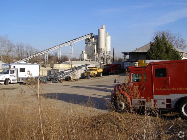
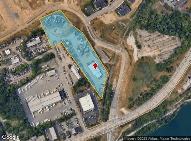
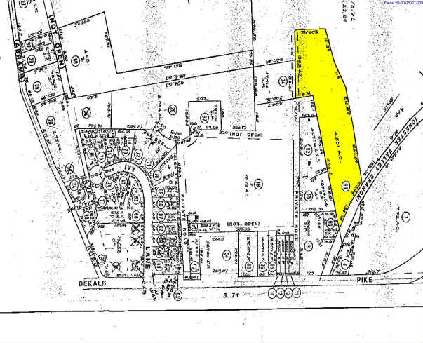
220 E Dekalb Pike
Philadelphia-Camden-Wilmington, PA-NJ-DE-MD
Subdivision Plan Made For Glasgow Quarri
58-00-06027-008
ASSESSOR BLOCK-UNIT NUMBER 11-95
Commercialnec
Montgomery
X
Pennsylvania
42029C0120G
95
2024
4.50 AC
2025
King of Prussia/Wayne
205805
Philadelphia
8,868 SF
DEMOGRAPHICS near 220 E Dekalb Pike
1 Mile
3 Mile
5 Mile
2024 Total Population
9,573
93,607
215,304
2029 Population
9,802
95,331
219,845
Pop Growth 2024-2029
+ 2.39%
+ 1.84%
+ 2.11%
Average Age
39
39
40
2024 Total Households
3,965
38,116
84,802
HH Growth 2024-2029
+ 2.77%
+ 2.04%
+ 2.27%
Median Household Inc
$98,650
$82,878
$100,474
Avg Household Size
2.30
2.40
2.40
2024 Avg HH Vehicles
2.00
2.00
2.00
Median Home Value
$328,527
$297,862
$389,971
Median Year Built
1962
1965
1968
Nearby Places
Map Layers
Map Styles
 Street
 Aerial
- Restaurants
- Banks
- Shops
- Fitness
- Groceries
PUBLIC TRANSPORTATION
COMMUTER RAIL
Norristown Transportation Center (R6 Line) (Manayunk/Norristown Line - SEPTA, R6 - SEPTA)
DRIVE
WALK
Distance
Norristown Transportation Center (R6 Line) (Manayunk/Norristown Line - SEPTA, R6 - SEPTA)
6 min
1.9 mi
Main Street (Norristown) (R6 - Southeastern Pennsylvania Transportation Authority Regional Rail (SEPTA Regional Rail))
DRIVE
WALK
Distance
Main Street (Norristown) (R6 - Southeastern Pennsylvania Transportation Authority Regional Rail (SEPTA Regional Rail))
5 min
2.0 mi
AIRPORT
Philadelphia International
DRIVE
WALK
Distance
Philadelphia International
43 min
26.0 mi
Freight Ports
Port of Philadelphia
DRIVE
WALK
Distance
Port of Philadelphia
38 min
23.3 mi
Nearby Properties
Address
Land Use
TOTAL SIZE
Lot Size
Zoning
Address
Land Use
TOTAL SIZE
Lot Size
Zoning
2,373,472 SF
96.77 AC
SC
Address
Land Use
TOTAL SIZE
Lot Size
Zoning
1,807,465 SF
120.12 AC
R2
Address
Land Use
TOTAL SIZE
Lot Size
Zoning
536,904 SF
8.84 AC
AG
Address
Land Use
TOTAL SIZE
Lot Size
Zoning
679,715 SF
58.23 AC
R2
Address
Land Use
TOTAL SIZE
Lot Size
Zoning
1,724,092 SF
24 AC
SC
Address
Land Use
TOTAL SIZE
Lot Size
Zoning
45,871 SF
112 AC
Address
Land Use
TOTAL SIZE
Lot Size
Zoning
628,694 SF
6.89 AC
AG
Address
Land Use
TOTAL SIZE
Lot Size
Zoning
649,339 SF
3.69 AC
AG
Address
Land Use
TOTAL SIZE
Lot Size
Zoning
546,664 SF
2.83 AC
AG
Address
Land Use
TOTAL SIZE
Lot Size
Zoning
388,042 SF
24.45 AC
SM
Address
Land Use
TOTAL SIZE
Lot Size
Zoning
547,377 SF
3.28 AC
AG
Address
Land Use
TOTAL SIZE
Lot Size
Zoning
454,933 SF
17.85 AC
SM
Address
Land Use
TOTAL SIZE
Lot Size
Zoning
872,232 SF
51.99 AC
G
Address
Land Use
TOTAL SIZE
Lot Size
Zoning
583,559 SF
AG
Address
Land Use
TOTAL SIZE
Lot Size
Zoning
413,892 SF
21.94 AC
SM
Address
Land Use
TOTAL SIZE
Lot Size
Zoning
493,690 SF
4.75 AC
AG
Address
Land Use
TOTAL SIZE
Lot Size
Zoning
843,567 SF
50.79 AC
HI
Address
Land Use
TOTAL SIZE
Lot Size
Zoning
502,080 SF
11.36 AC
RA
Address
Land Use
TOTAL SIZE
Lot Size
Zoning
260,938 SF
9.81 AC
SM1
Address
Land Use
TOTAL SIZE
Lot Size
Zoning
311,353 SF
7.41 AC
SM1
Address
Land Use
TOTAL SIZE
Lot Size
Zoning
488,970 SF
24.68 AC
AR
Address
Land Use
TOTAL SIZE
Lot Size
Zoning
197,108 SF
2.08 AC
SC
Address
Land Use
TOTAL SIZE
Lot Size
Zoning
503,942 SF
11.26 AC
RA
Address
Land Use
TOTAL SIZE
Lot Size
Zoning
804,184 SF
26.72 AC
HR
Address
Land Use
TOTAL SIZE
Lot Size
Zoning
414,642 SF
3.70 AC
AG
Address
Land Use
TOTAL SIZE
Lot Size
Zoning
370,404 SF
15.55 AC
SM1
Address
Land Use
TOTAL SIZE
Lot Size
Zoning
114,121 SF
16.80 AC
LI
Address
Land Use
TOTAL SIZE
Lot Size
Zoning
381,927 SF
5.10 AC
SM
Address
Land Use
TOTAL SIZE
Lot Size
Zoning
961,106 SF
5.47 AC
LI
Address
Land Use
TOTAL SIZE
Lot Size
Zoning
918,170 SF
89.93 AC
LI
The World's #1 Commercial Real Estate Marketplace
Connect with us
© 2025 CoStar Group
The information above has been obtained from sources believed reliable. While we do not doubt its accuracy we have not verified it and make no guarantee, warranty or representation about it. It is your responsibility to independently confirm its accuracy and completeness. Any projections, opinions, assumptions, or estimates used are for example only and do not represent the current or future performance of the property. The value of this transaction to you depends on tax and other factors which should be evaluated by your tax, financial, and legal advisors. You and your advisors should conduct a careful, independent investigation of the property to determine to your satisfaction the suitability of the property for your needs.