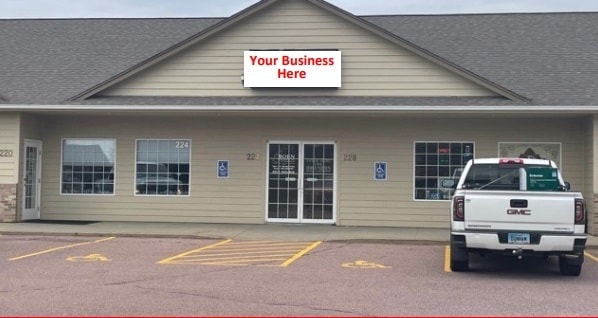
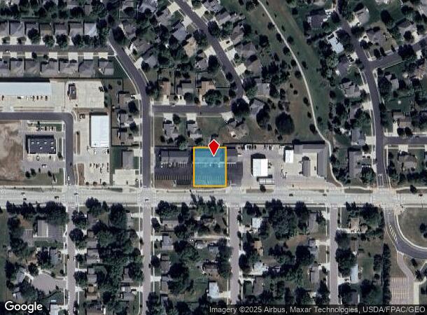
Property Record
220 E Holly Blvd, Brandon, SD 57005

NEARBY LISTINGS FOR SALE OR LEASE
-
-
View all Brandon listings for lease on LoopNet.com
Property Detail
220 E Holly Blvd
Sioux Falls, SD-MN
Thad-Tabor Est
65380
LOT 20A BLOCK 5 THAD-TABOR EST TO CITY OF BRANDON
Stripcommercialcenter
Minnehaha
X
South Dakota
19119C0025D
20a
2024
0.46 AC
2024
Sioux Falls
010501
Other Market Areas
4,056 SF
DEMOGRAPHICS near 220 E Holly Blvd
1 Mile
3 Mile
5 Mile
2024 Total Population
6,503
12,380
22,596
2029 Population
7,036
13,419
24,726
Pop Growth 2024-2029
+ 8.20%
+ 8.39%
+ 9.43%
Average Age
37
37
37
2024 Total Households
2,369
4,360
7,891
HH Growth 2024-2029
+ 8.57%
+ 8.74%
+ 9.75%
Median Household Inc
$100,753
$105,726
$107,565
Avg Household Size
2.70
2.80
2.80
2024 Avg HH Vehicles
2.00
2.00
2.00
Median Home Value
$289,184
$319,411
$344,614
Median Year Built
1995
1999
2002
Nearby Places
Map Layers
Map Styles
 Street
 Aerial
- Restaurants
- Banks
- Shops
- Fitness
- Groceries
PUBLIC TRANSPORTATION
AIRPORT
Joe Foss Field
DRIVE
WALK
Distance
Joe Foss Field
33 min
12.2 mi
Freight Ports
Port Milwaukee
DRIVE
WALK
Distance
Port Milwaukee
537 min
494.1 mi
SALE & LEASE HISTORY
LISTING DATE
SALE/LEASE

Apr 29, 2021
For Lease
Nearby Properties
Address
Land Use
TOTAL SIZE
Lot Size
Zoning
Address
Land Use
TOTAL SIZE
Lot Size
Zoning
43.83 AC
Address
Land Use
TOTAL SIZE
Lot Size
Zoning
6,564 SF
15.96 AC
Address
Land Use
TOTAL SIZE
Lot Size
Zoning
37,016 SF
5.29 AC
Address
Land Use
TOTAL SIZE
Lot Size
Zoning
20.57 AC
Address
Land Use
TOTAL SIZE
Lot Size
Zoning
8,348 SF
3.36 AC
I3;INDUSTR
Address
Land Use
TOTAL SIZE
Lot Size
Zoning
76,250 SF
11.01 AC
Address
Land Use
TOTAL SIZE
Lot Size
Zoning
56,160 SF
4.72 AC
Address
Land Use
TOTAL SIZE
Lot Size
Zoning
129,740 SF
6.45 AC
I3;INDUSTR
Address
Land Use
TOTAL SIZE
Lot Size
Zoning
1,200 SF
28.70 AC
I2
Address
Land Use
TOTAL SIZE
Lot Size
Zoning
52,056 SF
2 AC
Address
Land Use
TOTAL SIZE
Lot Size
Zoning
44,493 SF
2.26 AC
Address
Land Use
TOTAL SIZE
Lot Size
Zoning
4,268 SF
45.53 AC
A1
Address
Land Use
TOTAL SIZE
Lot Size
Zoning
1,344 SF
7.66 AC
Address
Land Use
TOTAL SIZE
Lot Size
Zoning
38,112 SF
12.42 AC
Address
Land Use
TOTAL SIZE
Lot Size
Zoning
22,757 SF
6.30 AC
Address
Land Use
TOTAL SIZE
Lot Size
Zoning
49,071 SF
1.67 AC
B2;RETAILF
Address
Land Use
TOTAL SIZE
Lot Size
Zoning
36,148 SF
9.03 AC
Address
Land Use
TOTAL SIZE
Lot Size
Zoning
25,196 SF
5.58 AC
Address
Land Use
TOTAL SIZE
Lot Size
Zoning
47,782 SF
4 AC
Address
Land Use
TOTAL SIZE
Lot Size
Zoning
33,792 SF
10 AC
RC;CONSERV
Address
Land Use
TOTAL SIZE
Lot Size
Zoning
43,973 SF
1.14 AC
R1;SINGLE
Address
Land Use
TOTAL SIZE
Lot Size
Zoning
40,800 SF
6.67 AC
Address
Land Use
TOTAL SIZE
Lot Size
Zoning
5,888 SF
33.65 AC
I2
Address
Land Use
TOTAL SIZE
Lot Size
Zoning
32,000 SF
2.98 AC
Address
Land Use
TOTAL SIZE
Lot Size
Zoning
8,944 SF
2.44 AC
Address
Land Use
TOTAL SIZE
Lot Size
Zoning
2,014 SF
3.73 AC
Address
Land Use
TOTAL SIZE
Lot Size
Zoning
32,640 SF
2.57 AC
Address
Land Use
TOTAL SIZE
Lot Size
Zoning
22,866 SF
1.65 AC
Address
Land Use
TOTAL SIZE
Lot Size
Zoning
8,344 SF
1.41 AC
Address
Land Use
TOTAL SIZE
Lot Size
Zoning
7,999 SF
0.92 AC
RC;CONSERV
The World's #1 Commercial Real Estate Marketplace
Connect with us
© 2026 CoStar Group
The information above has been obtained from sources believed reliable. While we do not doubt its accuracy we have not verified it and make no guarantee, warranty or representation about it. It is your responsibility to independently confirm its accuracy and completeness. Any projections, opinions, assumptions, or estimates used are for example only and do not represent the current or future performance of the property. The value of this transaction to you depends on tax and other factors which should be evaluated by your tax, financial, and legal advisors. You and your advisors should conduct a careful, independent investigation of the property to determine to your satisfaction the suitability of the property for your needs.