Property Record
220 Forest Rd, Bessemer, AL 35023


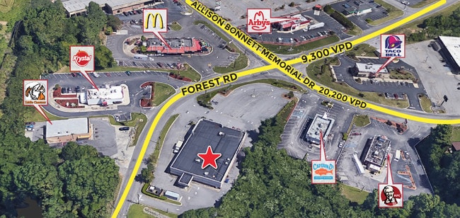

NEARBY LISTINGS FOR SALE OR LEASE
Property Detail
220 Forest Rd
30-00-29-2-006-003.000
COM NE INTERSEC FOREST RD & FOREST CIR IN NW4 SEC 29 TP 18 R 4W TH N ALONG FOREST RD 423.4 FT TO POB TH SE 116.1 FT TH NE 410.5 FT TO S LINE OF WARRIOR RIVER RD TH NWLY & SWLY ALG CURVE & ALG R/W OF TH NE 410.5 FT TO S LINE OF WARRIOR RIVER RD TH NWL
Medicalbuilding
Jefferson
X
Alabama
01073C0528G
1.13 AC
2024
Bessemer
2024
Birmingham
013902
Birmingham-Hoover, AL
11,099 SF
DEMOGRAPHICS near 220 Forest Rd
1 Mile
3 Mile
5 Mile
2024 Total Population
5,538
28,270
69,153
2029 Population
5,394
27,774
68,349
Pop Growth 2024-2029
(2.60%)
(1.75%)
(1.16%)
Average Age
41
41
41
2024 Total Households
2,186
11,036
27,208
HH Growth 2024-2029
(2.88%)
(1.84%)
(1.25%)
Median Household Inc
$52,102
$54,806
$46,819
Avg Household Size
2.40
2.50
2.40
2024 Avg HH Vehicles
2.00
2.00
2.00
Median Home Value
$132,009
$140,494
$131,533
Median Year Built
1965
1969
1966
Nearby Places
Map Layers
Map Styles
 Street
 Aerial
- Restaurants
- Banks
- Shops
- Fitness
- Groceries
PUBLIC TRANSPORTATION
AIRPORT
Birmingham-Shuttlesworth International
DRIVE
WALK
Distance
Birmingham-Shuttlesworth International
24 min
17.7 mi
Freight Ports
Port of Mobile
DRIVE
WALK
Distance
Port of Mobile
287 min
244.1 mi
SALE & LEASE HISTORY
LISTING DATE
SALE/LEASE

Sep 23, 2016
For Sale
Sep 21, 2018
For Lease
Feb 28, 2019
For Sale
Nearby Properties
Address
Land Use
TOTAL SIZE
Lot Size
Zoning
Address
Land Use
TOTAL SIZE
Lot Size
Zoning
1,244,986 SF
I2
Address
Land Use
TOTAL SIZE
Lot Size
Zoning
2,573,547 SF
112 AC
I2
Address
Land Use
TOTAL SIZE
Lot Size
Zoning
460,483 SF
20 AC
I3
Address
Land Use
TOTAL SIZE
Lot Size
Zoning
116,442 SF
2.67 AC
B6
Address
Land Use
TOTAL SIZE
Lot Size
Zoning
195,495 SF
28.97 AC
B3
Address
Land Use
TOTAL SIZE
Lot Size
Zoning
553,137 SF
87 AC
I2
Address
Land Use
TOTAL SIZE
Lot Size
Zoning
136,115 SF
14.90 AC
C3
Address
Land Use
TOTAL SIZE
Lot Size
Zoning
219,210 SF
19.40 AC
M2
Address
Land Use
TOTAL SIZE
Lot Size
Zoning
230,088 SF
I3
Address
Land Use
TOTAL SIZE
Lot Size
Zoning
66,928 SF
5.70 AC
B2-R
Address
Land Use
TOTAL SIZE
Lot Size
Zoning
77,902 SF
44 AC
I3
Address
Land Use
TOTAL SIZE
Lot Size
Zoning
58,822 SF
7.80 AC
B3
Address
Land Use
TOTAL SIZE
Lot Size
Zoning
1,200 SF
13.40 AC
R3
Address
Land Use
TOTAL SIZE
Lot Size
Zoning
69,344 SF
2.30 AC
B-1
Address
Land Use
TOTAL SIZE
Lot Size
Zoning
26,234 SF
3.30 AC
B2
Address
Land Use
TOTAL SIZE
Lot Size
Zoning
366,421 SF
21 AC
I3
Address
Land Use
TOTAL SIZE
Lot Size
Zoning
1,437,077 SF
I2
Address
Land Use
TOTAL SIZE
Lot Size
Zoning
80,043 SF
10.89 AC
B3-C
Address
Land Use
TOTAL SIZE
Lot Size
Zoning
163,056 SF
I-3
Address
Land Use
TOTAL SIZE
Lot Size
Zoning
49,022 SF
5.50 AC
R2
Address
Land Use
TOTAL SIZE
Lot Size
Zoning
80,220 SF
6.68 AC
M2
Address
Land Use
TOTAL SIZE
Lot Size
Zoning
52,810 SF
3.44 AC
B-3
Address
Land Use
TOTAL SIZE
Lot Size
Zoning
65,232 SF
3.60 AC
R-5
Address
Land Use
TOTAL SIZE
Lot Size
Zoning
59,554 SF
1.37 AC
R2
Address
Land Use
TOTAL SIZE
Lot Size
Zoning
32,606 SF
2.18 AC
B2-R
Address
Land Use
TOTAL SIZE
Lot Size
Zoning
130,563 SF
I3
Address
Land Use
TOTAL SIZE
Lot Size
Zoning
18,600 SF
2.80 AC
C4
Address
Land Use
TOTAL SIZE
Lot Size
Zoning
62,918 SF
3.59 AC
R2-R
Address
Land Use
TOTAL SIZE
Lot Size
Zoning
109,004 SF
I3
Address
Land Use
TOTAL SIZE
Lot Size
Zoning
47,232 SF
1.09 AC
B2-R
The World's #1 Commercial Real Estate Marketplace
Connect with us
© 2025 CoStar Group
The information above has been obtained from sources believed reliable. While we do not doubt its accuracy we have not verified it and make no guarantee, warranty or representation about it. It is your responsibility to independently confirm its accuracy and completeness. Any projections, opinions, assumptions, or estimates used are for example only and do not represent the current or future performance of the property. The value of this transaction to you depends on tax and other factors which should be evaluated by your tax, financial, and legal advisors. You and your advisors should conduct a careful, independent investigation of the property to determine to your satisfaction the suitability of the property for your needs.