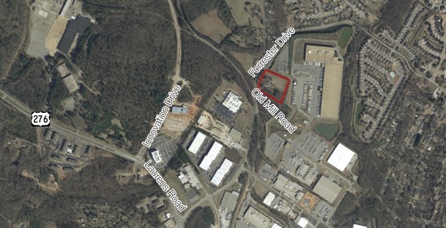
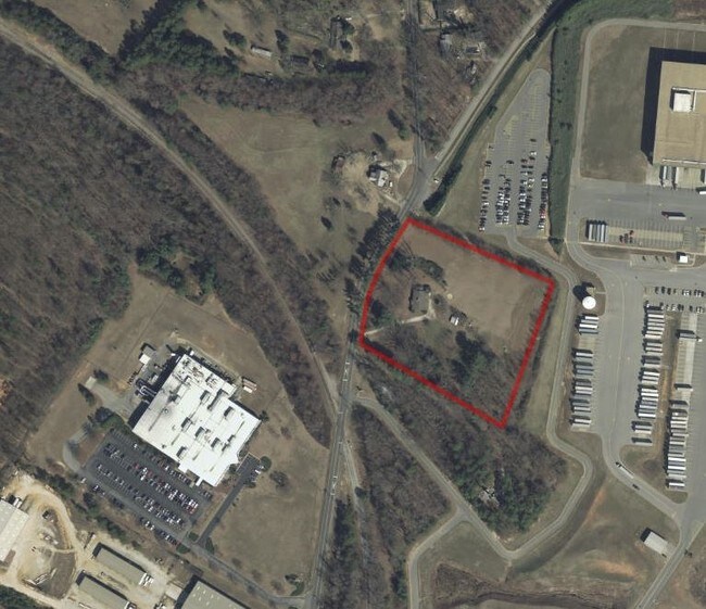
Property Record
220 Forrester Dr, Greenville, SC 29607

NEARBY LISTINGS FOR SALE OR LEASE
Property Detail
220 Forrester Dr
Greenville-Anderson-Greer, SC
Fant Reichert And Fogleman Inc
M009.01-01-008.00
MAP M009.01
Residentialacreage
Greenville
X
South Carolina
45045C0416E
008.00
2024
5.13 AC
2024
Woodruff/I-385 Corridor
002811
Greenville/Spartanburg
1,980 SF
DEMOGRAPHICS near 220 Forrester Dr
1 Mile
3 Mile
5 Mile
2024 Total Population
6,893
54,428
151,201
2029 Population
7,717
60,715
166,887
Pop Growth 2024-2029
+ 11.95%
+ 11.55%
+ 10.37%
Average Age
37
39
40
2024 Total Households
3,112
24,308
64,738
HH Growth 2024-2029
+ 12.02%
+ 11.68%
+ 10.51%
Median Household Inc
$76,172
$74,118
$73,909
Avg Household Size
2.20
2.20
2.30
2024 Avg HH Vehicles
2.00
2.00
2.00
Median Home Value
$250,000
$257,910
$276,376
Median Year Built
2010
1998
1991
Nearby Places
Map Layers
Map Styles
 Street
 Aerial
- Restaurants
- Banks
- Shops
- Fitness
- Groceries
PUBLIC TRANSPORTATION
COMMUTER RAIL
Greenville Amtrak Station (Crescent - Amtrak)
DRIVE
WALK
Distance
Greenville Amtrak Station (Crescent - Amtrak)
17 min
9.4 mi
AIRPORT
Greenville Spartanburg International
DRIVE
WALK
Distance
Greenville Spartanburg International
19 min
9.9 mi
Freight Ports
North Charleston Terminal
DRIVE
WALK
Distance
North Charleston Terminal
221 min
196.1 mi
SALE & LEASE HISTORY
LISTING DATE
SALE/LEASE

Sep 24, 2016
For Sale
Apr 06, 2017
For Sale
Nearby Properties
Address
Land Use
TOTAL SIZE
Lot Size
Zoning
Address
Land Use
TOTAL SIZE
Lot Size
Zoning
17.56 AC
C3
Address
Land Use
TOTAL SIZE
Lot Size
Zoning
16 AC
S1
Address
Land Use
TOTAL SIZE
Lot Size
Zoning
17.07 AC
S1
Address
Land Use
TOTAL SIZE
Lot Size
Zoning
20.63 AC
S1
Address
Land Use
TOTAL SIZE
Lot Size
Zoning
22.50 AC
S1
Address
Land Use
TOTAL SIZE
Lot Size
Zoning
15.82 AC
RM
Address
Land Use
TOTAL SIZE
Lot Size
Zoning
10.20 AC
R12
Address
Land Use
TOTAL SIZE
Lot Size
Zoning
10.07 AC
S1
Address
Land Use
TOTAL SIZE
Lot Size
Zoning
12.95 AC
RM3
Address
Land Use
TOTAL SIZE
Lot Size
Zoning
2,355 SF
10.21 AC
RS
Address
Land Use
TOTAL SIZE
Lot Size
Zoning
10.35 AC
R12
Address
Land Use
TOTAL SIZE
Lot Size
Zoning
223.09 AC
I1
Address
Land Use
TOTAL SIZE
Lot Size
Zoning
6.86 AC
S1
Address
Land Use
TOTAL SIZE
Lot Size
Zoning
10.29 AC
S1
Address
Land Use
TOTAL SIZE
Lot Size
Zoning
20.30 AC
I1
Address
Land Use
TOTAL SIZE
Lot Size
Zoning
3.24 AC
S1
Address
Land Use
TOTAL SIZE
Lot Size
Zoning
7.53 AC
S1
Address
Land Use
TOTAL SIZE
Lot Size
Zoning
11.05 AC
S1
Address
Land Use
TOTAL SIZE
Lot Size
Zoning
3.38 AC
S1
Address
Land Use
TOTAL SIZE
Lot Size
Zoning
6.27 AC
UVD
Address
Land Use
TOTAL SIZE
Lot Size
Zoning
181.61 AC
C-2,I1
Address
Land Use
TOTAL SIZE
Lot Size
Zoning
32.02 AC
R6
Address
Land Use
TOTAL SIZE
Lot Size
Zoning
Address
Land Use
TOTAL SIZE
Lot Size
Zoning
11.17 AC
C2
Address
Land Use
TOTAL SIZE
Lot Size
Zoning
5 AC
R12
Address
Land Use
TOTAL SIZE
Lot Size
Zoning
1.92 AC
S1
Address
Land Use
TOTAL SIZE
Lot Size
Zoning
0.34 AC
C3
Address
Land Use
TOTAL SIZE
Lot Size
Zoning
2.10 AC
S1
Address
Land Use
TOTAL SIZE
Lot Size
Zoning
5.47 AC
C3
Address
Land Use
TOTAL SIZE
Lot Size
Zoning
39.85 AC
C3
The World's #1 Commercial Real Estate Marketplace
Connect with us
© 2026 CoStar Group
The information above has been obtained from sources believed reliable. While we do not doubt its accuracy we have not verified it and make no guarantee, warranty or representation about it. It is your responsibility to independently confirm its accuracy and completeness. Any projections, opinions, assumptions, or estimates used are for example only and do not represent the current or future performance of the property. The value of this transaction to you depends on tax and other factors which should be evaluated by your tax, financial, and legal advisors. You and your advisors should conduct a careful, independent investigation of the property to determine to your satisfaction the suitability of the property for your needs.