Property Record
220 Franklin Rd, Randolph, NJ 07869
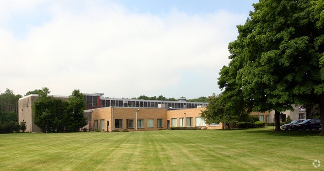

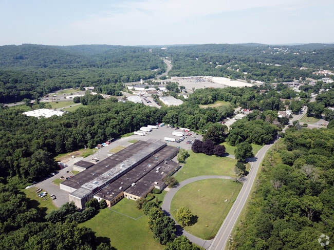
Property Detail
220 Franklin Rd
Newark, NJ
ADDITIONAL LOTS: B131 L46
32-00195-0000-00012
Morris
Industrialgeneral
New Jersey
I-1
12
2024
25.47 AC
2025
Route 80 Corridor
046500
Northern New Jersey
98,598 SF
NEARBY LISTINGS FOR SALE OR LEASE
DEMOGRAPHICS near 220 Franklin Rd
1 mile
3 mile
5 mile
2025 Total Population
7,440
73,367
142,565
2030 Population
7,614
75,209
146,454
Pop Growth 2025-2030
+ 2.34%
+ 2.51%
+ 2.73%
Average Age
40
42
42
2025 Total Households
2,557
26,460
51,850
HH Growth 2025-2030
+ 2.50%
+ 2.65%
+ 2.86%
Median Household Inc
$94,146
$109,933
$128,615
Avg Household Size
2.80
2.70
2.70
2025 Avg HH Vehicles
2.00
2.00
2.00
Median Home Value
$455,176
$469,342
$531,876
Median Year Built
1971
1969
1969
Nearby Places
Map Layers
Map Styles
 Street
 Aerial
Layers
 Traffic
 Biking
Places
Listings with unknown addresses are not visible on the map
- Restaurants
- Banks
- Shops
- Fitness
- Groceries
PUBLIC TRANSPORTATION
COMMUTER RAIL
Dover (Montclair-Boonton Line - NJ Transit Commuter Rail (NJ Transit), Morris & Essex Morristown Line - NJ Transit Commuter Rail (NJ Transit))
Drive
Walk
Distance
Dover (Montclair-Boonton Line - NJ Transit Commuter Rail (NJ Transit), Morris & Essex Morristown Line - NJ Transit Commuter Rail (NJ Transit))
5 min
1.8 mi
Denville (Montclair-Boonton Line - NJ Transit Commuter Rail (NJ Transit), Morris & Essex Morristown Line - NJ Transit Commuter Rail (NJ Transit))
Drive
Walk
Distance
Denville (Montclair-Boonton Line - NJ Transit Commuter Rail (NJ Transit), Morris & Essex Morristown Line - NJ Transit Commuter Rail (NJ Transit))
9 min
4.6 mi
AIRPORT
Newark Liberty International
Drive
Walk
Distance
Newark Liberty International
38 min
28.9 mi
Freight Ports
Maher Terminal
Drive
Walk
Distance
Maher Terminal
42 min
29.5 mi
SALE & LEASE HISTORY
LISTING DATE
SALE/LEASE

Sep 24, 2016
For Lease
Sep 24, 2016
For Sale
Sep 23, 2019
For Lease
Sep 23, 2016
For Sale
Jun 13, 2018
For Lease
Jul 18, 2017
For Sale
Jan 16, 2018
For Lease
Feb 20, 2019
For Lease
Aug 09, 2023
For Lease
Apr 17, 2023
For Lease
Nearby Properties
Address
Land Use
TOTAL SIZE
Lot Size
Zoning
Address
Land Use
TOTAL SIZE
Lot Size
Zoning
222.79 AC
R1
Address
Land Use
TOTAL SIZE
Lot Size
Zoning
401,303 SF
59.54 AC
R-B
Address
Land Use
TOTAL SIZE
Lot Size
Zoning
64.62 AC
R3
Address
Land Use
TOTAL SIZE
Lot Size
Zoning
30.13 AC
I-3
Address
Land Use
TOTAL SIZE
Lot Size
Zoning
95,368 SF
33.81 AC
RMF8
Address
Land Use
TOTAL SIZE
Lot Size
Zoning
28.62 AC
OSGU
Address
Land Use
TOTAL SIZE
Lot Size
Zoning
197,412 SF
28.60 AC
OSGU
Address
Land Use
TOTAL SIZE
Lot Size
Zoning
23.66 AC
I1
Address
Land Use
TOTAL SIZE
Lot Size
Zoning
20.05 AC
R-1
Address
Land Use
TOTAL SIZE
Lot Size
Zoning
97,716 SF
60.89 AC
0-2
Address
Land Use
TOTAL SIZE
Lot Size
Zoning
26,967 SF
14.06 AC
OB-4
Address
Land Use
TOTAL SIZE
Lot Size
Zoning
Address
Land Use
TOTAL SIZE
Lot Size
Zoning
156,564 SF
19.66 AC
B-2
Address
Land Use
TOTAL SIZE
Lot Size
Zoning
44,600 SF
18.62 AC
R-B
Address
Land Use
TOTAL SIZE
Lot Size
Zoning
195,773 SF
43.54 AC
R-4
Address
Land Use
TOTAL SIZE
Lot Size
Zoning
270,140 SF
51.78 AC
R-1B
Address
Land Use
TOTAL SIZE
Lot Size
Zoning
18.35 AC
RMF8
Address
Land Use
TOTAL SIZE
Lot Size
Zoning
180,636 SF
65.98 AC
I
Address
Land Use
TOTAL SIZE
Lot Size
Zoning
Address
Land Use
TOTAL SIZE
Lot Size
Zoning
19,106 SF
19.25 AC
R-B
Address
Land Use
TOTAL SIZE
Lot Size
Zoning
19.47 AC
R-4
Address
Land Use
TOTAL SIZE
Lot Size
Zoning
8.08 AC
I-1
Address
Land Use
TOTAL SIZE
Lot Size
Zoning
153,609 SF
17.54 AC
R-B
Address
Land Use
TOTAL SIZE
Lot Size
Zoning
13.53 AC
R10
Address
Land Use
TOTAL SIZE
Lot Size
Zoning
261,582 SF
18.38 AC
R-B
Address
Land Use
TOTAL SIZE
Lot Size
Zoning
25.95 AC
I-1
Address
Land Use
TOTAL SIZE
Lot Size
Zoning
38.15 AC
R-1
Address
Land Use
TOTAL SIZE
Lot Size
Zoning
199,694 SF
29.23 AC
B-3
Address
Land Use
TOTAL SIZE
Lot Size
Zoning
48,455 SF
8.66 AC
POS
Address
Land Use
TOTAL SIZE
Lot Size
Zoning
124,041 SF
13.72 AC
I
The World's #1 Commercial Real Estate Marketplace
Connect with us
© 2026 CoStar Group
The information above has been obtained from sources believed reliable. While we do not doubt its accuracy we have not verified it and make no guarantee, warranty or representation about it. It is your responsibility to independently confirm its accuracy and completeness. Any projections, opinions, assumptions, or estimates used are for example only and do not represent the current or future performance of the property. The value of this transaction to you depends on tax and other factors which should be evaluated by your tax, financial, and legal advisors. You and your advisors should conduct a careful, independent investigation of the property to determine to your satisfaction the suitability of the property for your needs.