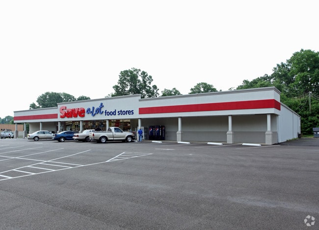
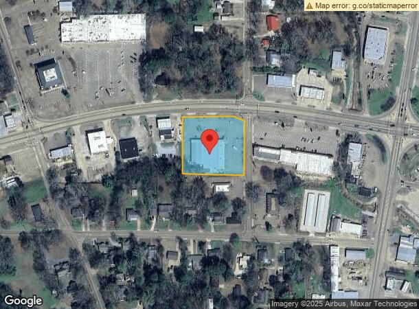
Property Record
220 Highway 6 W, Batesville, MS 38606

NEARBY LISTINGS FOR SALE OR LEASE
Property Detail
220 Highway 6 W
3182N0002200-A0000600
Maxey S/D
Storebuilding
LOTS 9-14 INCL S OF HWY 60.1) 255X290.1 - BLK A - MAXEY S/D PB 1A -DB Q9/207
X
Panola
28107C0312D
Mississippi
2024
9-14
2024
1.70 AC
950502
Tupelo/North Area
16,760 SF
Other Market Areas
DEMOGRAPHICS near 220 Highway 6 W
1 Mile
3 Mile
5 Mile
2024 Total Population
3,293
7,952
11,272
2029 Population
3,212
7,769
11,035
Pop Growth 2024-2029
(2.46%)
(2.30%)
(2.10%)
Average Age
38
38
38
2024 Total Households
1,206
2,928
4,156
HH Growth 2024-2029
(2.40%)
(2.29%)
(2.09%)
Median Household Inc
$44,999
$41,677
$46,830
Avg Household Size
2.60
2.60
2.60
2024 Avg HH Vehicles
2.00
2.00
2.00
Median Home Value
$138,781
$145,737
$138,056
Median Year Built
1980
1982
1984
Nearby Places
Map Layers
Map Styles
 Street
 Aerial
- Restaurants
- Banks
- Shops
- Fitness
- Groceries
SALE & LEASE HISTORY
LISTING DATE
SALE/LEASE

Jun 25, 2024
For Lease
Jun 22, 2024
For Sale
Dec 17, 2023
For Sale
Nearby Properties
Address
Land Use
TOTAL SIZE
Lot Size
Zoning
Address
Land Use
TOTAL SIZE
Lot Size
Zoning
138,838 SF
14.30 AC
Address
Land Use
TOTAL SIZE
Lot Size
Zoning
10,000 SF
90.70 AC
Address
Land Use
TOTAL SIZE
Lot Size
Zoning
119,834 SF
23.70 AC
Address
Land Use
TOTAL SIZE
Lot Size
Zoning
9,911 SF
9.80 AC
Address
Land Use
TOTAL SIZE
Lot Size
Zoning
5,802 SF
11.50 AC
Address
Land Use
TOTAL SIZE
Lot Size
Zoning
4,120 SF
39 AC
Address
Land Use
TOTAL SIZE
Lot Size
Zoning
108,001 SF
13.10 AC
Address
Land Use
TOTAL SIZE
Lot Size
Zoning
Address
Land Use
TOTAL SIZE
Lot Size
Zoning
5,901 SF
7 AC
Address
Land Use
TOTAL SIZE
Lot Size
Zoning
7,492 SF
45.50 AC
Address
Land Use
TOTAL SIZE
Lot Size
Zoning
2.20 AC
Address
Land Use
TOTAL SIZE
Lot Size
Zoning
49,248 SF
2.40 AC
Address
Land Use
TOTAL SIZE
Lot Size
Zoning
41,413 SF
2.80 AC
Address
Land Use
TOTAL SIZE
Lot Size
Zoning
20,172 SF
2.10 AC
Address
Land Use
TOTAL SIZE
Lot Size
Zoning
6,000 SF
8.60 AC
Address
Land Use
TOTAL SIZE
Lot Size
Zoning
50,486 SF
3 AC
Address
Land Use
TOTAL SIZE
Lot Size
Zoning
88,114 SF
10.30 AC
Address
Land Use
TOTAL SIZE
Lot Size
Zoning
29,333 SF
1.80 AC
Address
Land Use
TOTAL SIZE
Lot Size
Zoning
42,389 SF
12.70 AC
Address
Land Use
TOTAL SIZE
Lot Size
Zoning
5,725 SF
0.57 AC
Address
Land Use
TOTAL SIZE
Lot Size
Zoning
15,086 SF
1.80 AC
Address
Land Use
TOTAL SIZE
Lot Size
Zoning
8,554 SF
22.70 AC
The World's #1 Commercial Real Estate Marketplace
Connect with us
© 2026 CoStar Group
The information above has been obtained from sources believed reliable. While we do not doubt its accuracy we have not verified it and make no guarantee, warranty or representation about it. It is your responsibility to independently confirm its accuracy and completeness. Any projections, opinions, assumptions, or estimates used are for example only and do not represent the current or future performance of the property. The value of this transaction to you depends on tax and other factors which should be evaluated by your tax, financial, and legal advisors. You and your advisors should conduct a careful, independent investigation of the property to determine to your satisfaction the suitability of the property for your needs.