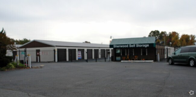
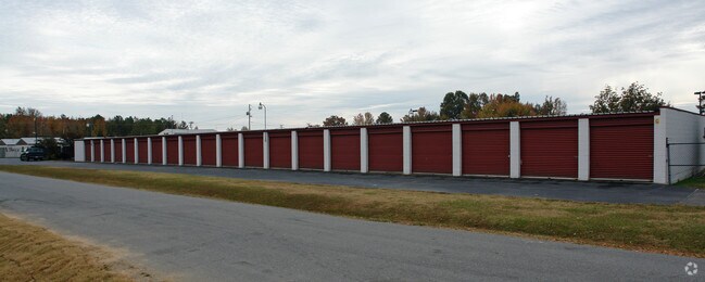
Property Record
220 Jan Dr, Sherwood, AR 72120

NEARBY LISTINGS FOR SALE OR LEASE
Property Detail
220 Jan Dr
23S-003-00-017-00
Manson Road Commercial Addition
Apartment
PT NE SW MPDA BEG 25W & 795S OF NE COR SW1/4 TH W307.7 N300 W310.4 N140 E617.4 TH S440 TO POB SECT 4-2N-11W 4 2N 11W
X
Pulaski
05119C0354G
Arkansas
2025
4.10 AC
2025
Outlying Pulaski County
003704
Little Rock/N Little Rock
10,850 SF
Little Rock-North Little Rock-Conway, AR
DEMOGRAPHICS near 220 Jan Dr
1 Mile
3 Mile
5 Mile
2024 Total Population
6,609
37,168
79,197
2029 Population
6,580
36,962
78,896
Pop Growth 2024-2029
(0.44%)
(0.55%)
(0.38%)
Average Age
38
41
40
2024 Total Households
2,835
15,669
33,393
HH Growth 2024-2029
(0.46%)
(0.64%)
(0.37%)
Median Household Inc
$52,324
$68,817
$58,255
Avg Household Size
2.30
2.30
2.30
2024 Avg HH Vehicles
2.00
2.00
2.00
Median Home Value
$187,275
$182,652
$173,927
Median Year Built
1986
1985
1979
Nearby Places
Map Layers
Map Styles
 Street
 Aerial
- Restaurants
- Banks
- Shops
- Fitness
- Groceries
PUBLIC TRANSPORTATION
COMMUTER RAIL
Little Rock Union Station (Texas Eagle - Amtrak)
DRIVE
WALK
Distance
Little Rock Union Station (Texas Eagle - Amtrak)
14 min
9.3 mi
AIRPORT
Bill and Hillary Clinton Ntl/Adams Field
DRIVE
WALK
Distance
Bill and Hillary Clinton Ntl/Adams Field
19 min
12.8 mi
Freight Ports
Port of Shreveport
DRIVE
WALK
Distance
Port of Shreveport
260 min
241.7 mi
Nearby Properties
Address
Land Use
TOTAL SIZE
Lot Size
Zoning
Address
Land Use
TOTAL SIZE
Lot Size
Zoning
316,927 SF
50.65 AC
Address
Land Use
TOTAL SIZE
Lot Size
Zoning
82,978 SF
12.54 AC
Address
Land Use
TOTAL SIZE
Lot Size
Zoning
72,806 SF
10.95 AC
Address
Land Use
TOTAL SIZE
Lot Size
Zoning
17,352 SF
42.55 AC
Address
Land Use
TOTAL SIZE
Lot Size
Zoning
38,202 SF
14.23 AC
Address
Land Use
TOTAL SIZE
Lot Size
Zoning
36,934 SF
15.06 AC
Address
Land Use
TOTAL SIZE
Lot Size
Zoning
75,462 SF
5.33 AC
Address
Land Use
TOTAL SIZE
Lot Size
Zoning
219,330 SF
24.14 AC
Address
Land Use
TOTAL SIZE
Lot Size
Zoning
83,431 SF
10.99 AC
Address
Land Use
TOTAL SIZE
Lot Size
Zoning
49,995 SF
12.92 AC
Address
Land Use
TOTAL SIZE
Lot Size
Zoning
72,157 SF
9.45 AC
Address
Land Use
TOTAL SIZE
Lot Size
Zoning
31,644 SF
Address
Land Use
TOTAL SIZE
Lot Size
Zoning
56,643 SF
9.46 AC
Address
Land Use
TOTAL SIZE
Lot Size
Zoning
62,316 SF
6.23 AC
Address
Land Use
TOTAL SIZE
Lot Size
Zoning
28,947 SF
8.29 AC
Address
Land Use
TOTAL SIZE
Lot Size
Zoning
105,516 SF
9.31 AC
Address
Land Use
TOTAL SIZE
Lot Size
Zoning
60,539 SF
2.95 AC
Address
Land Use
TOTAL SIZE
Lot Size
Zoning
8,520 SF
11.30 AC
Address
Land Use
TOTAL SIZE
Lot Size
Zoning
39,513 SF
Address
Land Use
TOTAL SIZE
Lot Size
Zoning
45,500 SF
12.07 AC
Address
Land Use
TOTAL SIZE
Lot Size
Zoning
100,163 SF
15.51 AC
Address
Land Use
TOTAL SIZE
Lot Size
Zoning
111,425 SF
1.69 AC
Address
Land Use
TOTAL SIZE
Lot Size
Zoning
145,604 SF
12.62 AC
Address
Land Use
TOTAL SIZE
Lot Size
Zoning
32,788 SF
3.99 AC
Address
Land Use
TOTAL SIZE
Lot Size
Zoning
33,597 SF
Address
Land Use
TOTAL SIZE
Lot Size
Zoning
141,664 SF
12.21 AC
Address
Land Use
TOTAL SIZE
Lot Size
Zoning
44,092 SF
7.97 AC
Address
Land Use
TOTAL SIZE
Lot Size
Zoning
3,306 SF
8.33 AC
Address
Land Use
TOTAL SIZE
Lot Size
Zoning
54,401 SF
1.68 AC
Address
Land Use
TOTAL SIZE
Lot Size
Zoning
40,065 SF
8.26 AC
The World's #1 Commercial Real Estate Marketplace
Connect with us
© 2025 CoStar Group
The information above has been obtained from sources believed reliable. While we do not doubt its accuracy we have not verified it and make no guarantee, warranty or representation about it. It is your responsibility to independently confirm its accuracy and completeness. Any projections, opinions, assumptions, or estimates used are for example only and do not represent the current or future performance of the property. The value of this transaction to you depends on tax and other factors which should be evaluated by your tax, financial, and legal advisors. You and your advisors should conduct a careful, independent investigation of the property to determine to your satisfaction the suitability of the property for your needs.