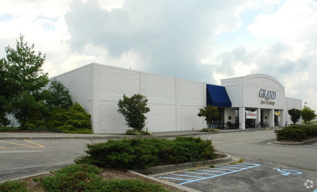
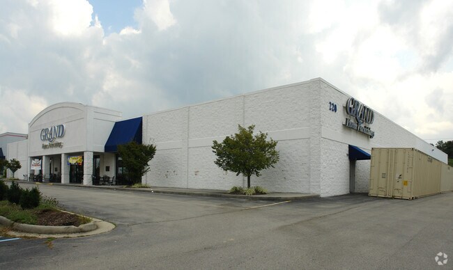
Property Record
220 Laurel St, Christiansburg, VA 24073


NEARBY LISTINGS FOR SALE OR LEASE
Property Detail
220 Laurel St
Blacksburg-Christiansburg-Radford, VA
Arbor View
031908
ARBOR VIEW PLAN PH VIII LOT 25
Commercialnec
Montgomery
X
Virginia
51121C0141C
25
2025
4.27 AC
2025
Blacksburg & Wytheville
020801
Other Market Areas
39,255 SF
DEMOGRAPHICS near 220 Laurel St
1 Mile
3 Mile
5 Mile
2024 Total Population
2,656
24,550
49,539
2029 Population
2,637
24,279
49,020
Pop Growth 2024-2029
(0.72%)
(1.10%)
(1.05%)
Average Age
39
41
38
2024 Total Households
1,140
10,693
21,609
HH Growth 2024-2029
(0.70%)
(1.08%)
(1.06%)
Median Household Inc
$75,690
$61,956
$58,581
Avg Household Size
2.30
2.20
2.20
2024 Avg HH Vehicles
2.00
2.00
2.00
Median Home Value
$245,625
$241,799
$261,703
Median Year Built
2000
1991
1988
Nearby Places
Map Layers
Map Styles
 Street
 Aerial
- Restaurants
- Banks
- Shops
- Fitness
- Groceries
PUBLIC TRANSPORTATION
AIRPORT
Roanoke/Blacksburg Regional (Woodrum Field)
DRIVE
WALK
Distance
Roanoke/Blacksburg Regional (Woodrum Field)
49 min
35.0 mi
Freight Ports
Virginia Port Authority - Richmond
DRIVE
WALK
Distance
Virginia Port Authority - Richmond
251 min
218.8 mi
Nearby Properties
Address
Land Use
TOTAL SIZE
Lot Size
Zoning
Address
Land Use
TOTAL SIZE
Lot Size
Zoning
50,000 SF
25.93 AC
R&D
Address
Land Use
TOTAL SIZE
Lot Size
Zoning
190,465 SF
30.37 AC
R1
Address
Land Use
TOTAL SIZE
Lot Size
Zoning
96,768 SF
20.18 AC
RM1
Address
Land Use
TOTAL SIZE
Lot Size
Zoning
189,259 SF
31.06 AC
R&D
Address
Land Use
TOTAL SIZE
Lot Size
Zoning
7.38 AC
R&D
Address
Land Use
TOTAL SIZE
Lot Size
Zoning
33,716 SF
15.72 AC
R&D
Address
Land Use
TOTAL SIZE
Lot Size
Zoning
33.70 AC
A1
Address
Land Use
TOTAL SIZE
Lot Size
Zoning
151,388 SF
18.29 AC
B3
Address
Land Use
TOTAL SIZE
Lot Size
Zoning
151,450 SF
13.88 AC
B3
Address
Land Use
TOTAL SIZE
Lot Size
Zoning
538,247 SF
54.60 AC
B3
Address
Land Use
TOTAL SIZE
Lot Size
Zoning
6.48 AC
GC
Address
Land Use
TOTAL SIZE
Lot Size
Zoning
66,896 SF
4 AC
O
Address
Land Use
TOTAL SIZE
Lot Size
Zoning
51,036 SF
14.21 AC
R&D
Address
Land Use
TOTAL SIZE
Lot Size
Zoning
57,936 SF
10.38 AC
R&D
Address
Land Use
TOTAL SIZE
Lot Size
Zoning
200,004 SF
23.11 AC
B3
Address
Land Use
TOTAL SIZE
Lot Size
Zoning
95,793 SF
6.95 AC
PR
Address
Land Use
TOTAL SIZE
Lot Size
Zoning
111,796 SF
15.03 AC
IN
Address
Land Use
TOTAL SIZE
Lot Size
Zoning
147,552 SF
4.54 AC
I2
Address
Land Use
TOTAL SIZE
Lot Size
Zoning
54,510 SF
10.43 AC
IN
Address
Land Use
TOTAL SIZE
Lot Size
Zoning
3.86 AC
Address
Land Use
TOTAL SIZE
Lot Size
Zoning
124,503 SF
11.30 AC
B3
Address
Land Use
TOTAL SIZE
Lot Size
Zoning
49,525 SF
11.07 AC
B3
Address
Land Use
TOTAL SIZE
Lot Size
Zoning
108,510 SF
11.89 AC
B3
Address
Land Use
TOTAL SIZE
Lot Size
Zoning
7.95 AC
A
Address
Land Use
TOTAL SIZE
Lot Size
Zoning
19,115 SF
10.14 AC
R&D
Address
Land Use
TOTAL SIZE
Lot Size
Zoning
281,082 SF
33.56 AC
I2
Address
Land Use
TOTAL SIZE
Lot Size
Zoning
99,595 SF
11.92 AC
B3
Address
Land Use
TOTAL SIZE
Lot Size
Zoning
128,416 SF
17.24 AC
B3
Address
Land Use
TOTAL SIZE
Lot Size
Zoning
61,328 SF
2.33 AC
B3
Address
Land Use
TOTAL SIZE
Lot Size
Zoning
45,079 SF
0.02 AC
R&D
The World's #1 Commercial Real Estate Marketplace
Connect with us
© 2026 CoStar Group
The information above has been obtained from sources believed reliable. While we do not doubt its accuracy we have not verified it and make no guarantee, warranty or representation about it. It is your responsibility to independently confirm its accuracy and completeness. Any projections, opinions, assumptions, or estimates used are for example only and do not represent the current or future performance of the property. The value of this transaction to you depends on tax and other factors which should be evaluated by your tax, financial, and legal advisors. You and your advisors should conduct a careful, independent investigation of the property to determine to your satisfaction the suitability of the property for your needs.